Enrile (Cagayan)
| Municipality of Enrile | ||
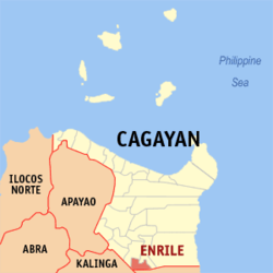
| Location of Enrile (Cagayan) in the province of Cagayan | ||
|---|---|---|

|
||
| Basic data | ||
| Region : | Cagayan Valley | |
| Province : | Cagayan | |
| Barangays : | 22nd | |
| District: | 3. District of Cagayan | |
| PSGC : | 021512000 | |
| Income class : | 4. Income bracket | |
| Households : | 5223 May 1, 2000 census
|
|
| Population : | 35,834 August 1, 2015 census
|
|
| Coordinates : | 17 ° 33 ' N , 121 ° 41' E | |
| Geographical location in the Philippines | ||
|
|
||
Enrile is a municipality in the Cagayan province of the Philippines . The municipality is located in the south of the province. In the southwest corner it borders on the province of Kalinga and in the rest of the south on the province of Isabela . In 2015 it had 35,834 inhabitants. The area was populated before the Spanish conquest and was previously called Cabug . The majority of the population lives from the cultivation of rice , mung beans and peanuts .
Enrile is divided into the following 22 barangays :
|
|
