Sanchez-Mira
| Municipality of Sanchez-Mira | ||
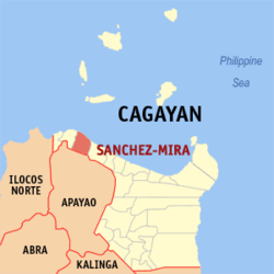
| Location of Sanchez-Mira in the province of Cagayan | ||
|---|---|---|

|
||
| Basic data | ||
| Region : | Cagayan Valley | |
| Province : | Cagayan | |
| Barangays : | 18th | |
| District: | 2. District of Cagayan | |
| PSGC : | 021522000 | |
| Income class : | 4. Income bracket | |
| Households : | 4139 May 1, 2000 census
|
|
| Population : | 24,541 August 1, 2015 census
|
|
| Population density : | 123.9 inhabitants per km² | |
| Area : | 198 km² | |
| Coordinates : | 18 ° 31 ' N , 121 ° 13' E | |
| Postal code : | 3518 | |
| Area code : | +63 78 | |
| Website: | www.sanchezmira-cagayan.gov.ph | |
| Geographical location in the Philippines | ||
|
|
||
Sanchez-Mira is a municipality in the Philippine province of Cagayan and is located in the northwest of the province on the South China Sea . In 2015, 24,541 people lived in the 198 km² area, resulting in a population density of 124 inhabitants per km². On the coast, heavily forested mountains protrude from the sea, some of which are over 500 meters high. The population, who have their settlements on the coast and in the valleys, live largely from agriculture and fishing. The locals belong to the Kalinga tribe . In the south the municipality borders on the province of Apayao . A major educational institution in the community is Cagayan State University .
Sanchez-Mira is divided into the following 18 barangays :
|
|
