Tuguegarao
| Tuguegarao City | ||
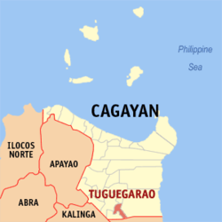
| Location of Tuguegarao City in Cagayan Province | ||
|---|---|---|

|
||
| Basic data | ||
| Region : | Cagayan Valley | |
| Province : | Cagayan | |
| Barangays : | 49 | |
| District: | 3. District of Cagayan | |
| PSGC : | 021529000 | |
| Income class : | 3rd income bracket | |
| Households : | 22,311 May 1, 2000 census
|
|
| Population : | 153.502 August 1, 2015 census
|
|
| Population density : | 1060 inhabitants per km² | |
| Area : | 144.8 km² | |
| Coordinates : | 17 ° 37 ′ N , 121 ° 43 ′ E | |
| Postal code : | 3500 | |
| Area code : | +63 78 | |
| Mayor : | Dolphin Telan Ting | |
| Website: | tuguegaraocity.gov.ph | |
| Geographical location in the Philippines | ||
|
|
||
Tuguegarao is a city in the Philippines in the Cagayan Province . Tuguegarao is the capital of the province and is located on the Cagayan River on the southern border of Cagayan. On August 1, 2015, the city had 153,502 inhabitants.
history
The first reports of a settlement were in 1604. After that, Tuguegarao grew in size, especially since Lal-Lo became the provincial capital in 1839. In 1893 Tuguegarao became the provincial capital because of its economic development. American troops occupied the city on December 12, 1899.
During the Second World War , the city fell to Japan on December 12, 1941, as the airfield was particularly important. The city and the airport were eventually bombed by US airmen between January and May 1945. Filipino guerrillas liberated the city from the Japanese in June . On June 25, the city was officially liberated.
In 1975 Tuguegarao even became the capital of the Cagayan Valley district , as it is particularly suitable as the administrative seat of government due to its geographical location in the center of the district.
City structure
Tuguegarao is divided into the following 49 barangays :
|
|
|
Sightseeing and education
At the Cagayan Museum and Historical Research Center, finds from excavations from the archaeological dig sites in the Cagayan Valley are presented. A major educational institution in the community is Cagayan State University .
Sons and daughters
- Ricardo Lingan Baccay (* 1961), Roman Catholic clergyman, Archbishop of Tuguegarao
- Danilo Ulep (* 1962), Roman Catholic clergyman, prelate of Batanes
swell
- Households: 2000 Philippine Census Information ( Memento from January 30, 2010 in the Internet Archive )
- Philippine Standard Geographic Code
