Buguey
| Municipality of Buguey | ||
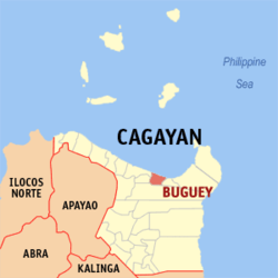
| Location of Buguey in the province of Cagayan | ||
|---|---|---|

|
||
| Basic data | ||
| Region : | Cagayan Valley | |
| Province : | Cagayan | |
| Barangays : | 30th | |
| District: | 1. District of Cagayan | |
| PSGC : | 021508000 | |
| Income class : | 4. Income bracket | |
| Households : | 5113 May 1, 2000 census
|
|
| Population : | 30,175 August 1, 2015 census
|
|
| Population density : | 168.9 inhabitants per km² | |
| Area : | 178.7 km² | |
| Coordinates : | 18 ° 17 ′ N , 121 ° 50 ′ E | |
| Geographical location in the Philippines | ||
|
|
||
Buguey is a municipality in the Philippine province of Cagayan . The municipality is located in the north of the province on the South China Sea and was founded in 1623 . The largest ethnic group in the place are the Ibanag .
Buguey is divided into the following 30 barangays :
|
|
