Santa Ana (Cagayan)
| Municipality of Santa Ana | ||
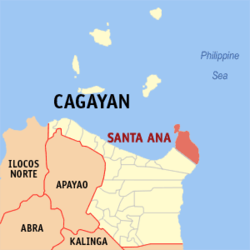
| Location of Santa Ana in the province of Cagayan | ||
|---|---|---|

|
||
| Basic data | ||
| Region : | Cagayan Valley | |
| Province : | Cagayan | |
| Barangays : | 16 | |
| District: | 1. District of Cagayan | |
| PSGC : | 021523000 | |
| Income class : | 3rd income bracket | |
| Households : | 4101 May 1, 2000 census
|
|
| Population : | 32,906 August 1, 2015 census
|
|
| Coordinates : | 18 ° 24 ' N , 122 ° 13' E | |
| Postal code : | 3514 | |
| Geographical location in the Philippines | ||
|
|
||
Santa Ana is a municipality in the Philippine province of Cagayan and is located in the extreme northeast of the province. In 2015 it had 32,906 inhabitants. Originally the area was inhabited exclusively by Negritos . Only at the end of the 19th century did other peoples find a home here. In 1949 Santa Ana got the status of a township.
In the west there are long white beaches and a large rice-growing area. The forest is only very limited here due to the ongoing deforestation. In the east, on the other hand, the land falls more steeply into the water and is more forested. The municipality also includes the large island of Palaui in the north and a lighthouse. Most of the population lives from agriculture, the timber industry and fishing.
Santa Ana is divided into the following 16 barangays :
|
|
Web links
- elgu2.ncc.gov.ph - Santa Ana ( Memento from September 19, 2007 in the Internet Archive )
