Pamplona (Cagayan)
| Municipality of Pamplona | ||
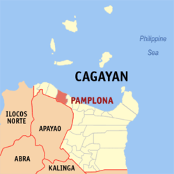
| Location of Pamplona in the province of Cagayan | ||
|---|---|---|

|
||
| Basic data | ||
| Region : | Cagayan Valley | |
| Province : | Cagayan | |
| Barangays : | 18th | |
| District: | 2. District of Cagayan | |
| PSGC : | 021518000 | |
| Income class : | 4. Income bracket | |
| Households : | 3787 May 1, 2000 census
|
|
| Population : | 23,596 August 1, 2015 census
|
|
| Population density : | 137.4 inhabitants per km² | |
| Area : | 171.7 km² | |
| Coordinates : | 18 ° 27 ′ N , 121 ° 21 ′ E | |
| Postal code : | 3522 | |
| Website: | www.pamplona-cagayan.gov.ph | |
| Geographical location in the Philippines | ||
|
|
||
Pamplona is a municipality in the Philippine province of Cagayan and is located in the north of the province on the Philippine Sea . In 2015, 23,596 people lived in the 171.7 km² area, resulting in a population density of 137 inhabitants per km². In the south, the municipality borders on Luna in the province of Apayao , in the east on Abulug and in the west on Sanchez-Mira .
Pamplona was created in 1844 by merging the two places Abulacan and Masi . The native inhabitants of the area are the Ibanag , but they are increasingly being displaced by the Ilokanos .
Pamplona is divided into the following 18 barangays :
|
|
