Alcala (Cagayan)
| Municipality of Alcala | ||
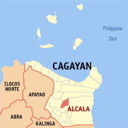
| Location of Alcala in the province of Cagayan | ||
|---|---|---|

|
||
| Basic data | ||
| Region : | Cagayan Valley | |
| Province : | Cagayan | |
| Barangays : | 25th | |
| PSGC : | 021502000 | |
| Income class : | 4. Income bracket | |
| Households : | 7025 May 1, 2000 census
|
|
| Population : | 38,883 August 1, 2015 census
|
|
| Population density : | 207.7 inhabitants per km² | |
| Area : | 187.2 km² | |
| Coordinates : | 17 ° 56 ′ N , 121 ° 40 ′ E | |
| Postal code : | 3507 | |
| Geographical location in the Philippines | ||
|
|
||
Alcala is a municipality founded in 1789 on the island of Luzon in the Philippine province of Cagayan .
population
The 187.2 km² area had a population of 38,883 on August 1, 2015. The population density is 208 inhabitants per km².
The majority of the population lives from agriculture.
useful information
In Cagayan, Alcala is known for its caramel cream .
Baranggay division
Alcala is divided into the following 25 barangays :
|
|
