
Bramsche (Lingen)
|
Bramsche
City of Lingen (Ems)
Coordinates: 52 ° 27 '26 " N , 7 ° 21' 49" E
|
||
|---|---|---|
| Height : | 24 m above sea level NN | |
| Residents : | 2500 (December 31, 2015) | |
| Incorporation : | March 1, 1974 | |
| Postal code : | 49811 | |
| Area code : | 05906 | |
Location of Bramsche in Lower Saxony |
||

Bramsche is a district of Lingen (Ems) in the Emsland district in Lower Saxony . Until 1974 Bramsche was part of the municipality of Bramsche-Wesel and since then has formed a locality together with the other places of the former municipality of Bramsche . Bramsche is on the B 70 , which leads from Neermoor via Rheine to Wesel on the Lower Rhine. The place is the center of eight farming communities : Kring, Wesel, summer Willingen, Hüvede, Mundersum, Estringen, Rottum and Polle, the independent part communities were.
landscape
The landscape around Bramsche is characterized by the Ems , the Dortmund-Ems Canal and the Aa . To the west of the district is the Aaberge nature reserve. The renatured Südbach was declared a natural monument. The so-called “1000-year-old oak ” was also a natural monument ; it was set on fire and largely destroyed as a result; only the trunk stands. One of the largest contiguous forest areas in the Emsland is used to relax the residents. The Gleesen-Papenburg side canal represents nature from “second hand” . Before the war , the side canal was planned as a new canal bed from Gleesen to Papenburg, but was never completed.
history
Early history
Excavations as well as hill and stone graves ( large stone grave Mundersum , large stone grave Gleesen and large stone grave Bramsche-Wesel ) show that people settled in the Bramsche area as early as the Middle Neolithic (approx. 4,000–2,000 BC). These large stone graves were erected during the funnel cup culture. Local researcher Heinrich Bröcker found richly decorated shards and around 50 urns near the large stone grave in Mundersumer Sand. He also discovered another urn cemetery south of Bramsche an der Surbecke, about 200 meters from Weseler Straße. Near the peasantry Mundersum, north of Bramsche, the local historian Franz Wolf discovered further 55 prehistoric and early historic sites, stone graves with weapons, vessels and equipment from the Stone Age (4000 to 2000 v. Chr.), A Stone Age pit house, Barrows from the Bronze Age with numerous urn finds (2000–750 BC) and a Germanic iron smelter in the Hüvede farmers. In the vicinity of the Estringen farmers, on the Lüberg, the local history researcher Heinrich Timmerbeil discovered a grave site with several urns and grave goods from around 800 AD. Among the grave goods there was a chain with over 60 hazelnut-sized clay beads with a Bronze clasp. This find is exhibited in the Municipal Museum of Osnabrück.
middle Ages

Around the year 1000 Bramsche first appeared by name in the Werdener Urbar as part of the Venkigau . The Corveyer Heberegister mentions Bremesge also around 1000. In a document from 1463 it says: Bramesche op den Huuetfelde in the Ampte von Lynge . Bramsche belonged in the modern era to the county Lingen .
Spyck Castle was built south of Bramsche on the Große Aa in the 15th century, and it is said to have been owned by the von Senden family from the Münsterland. However, no records or documents have been found to date. Likewise, no remains of the castle such as foundations were discovered on today's manor district. It has been proven that the von Senden family was the owner between 1412 and 1463. The castle in the village center, mentioned in a document, with its lord, Knight Otto von Grothaus, was already destroyed at this time. There are indications that the steeple of the Bramsch Church could have been part of Bramesge Castle .
The time of the Reformation
Konrad von Tecklenburg-Schwerin , Count of the County of Lingen , introduced the Reformation in 1543 , including in Bramsche. The Calvinist preacher Joh. Horstel became pastor in Bramsche . After the defeat of the Schmalkaldic Federation , Konrad von Tecklenburg-Schwerin had to cede the county of Lingen in 1548. By losing his reign in 1548, Bramsche became Catholic again. From 1597 to 1605, when the County of Lingen was part of the Union of Utrecht , Pastor Albertus Hoett preached in Bramsche. After the Prince of Orange took possession of the county of Lingen again in 1633, he had the parishes in the county occupied by Calvinist preachers; the smaller parish of Bramsche was left to the Catholics . After the end of the Thirty Years' War the Bramsche congregation also got a Calvinist preacher. The church ordinance of the Orange banned Catholic priests and sextons from working in Bramsche, so that the Bramsch Catholics went to mass in the Tegder barn in Gleesen until 1702 .
19th century
With the annexation of north-west German areas from January 1, 1811 by the Napoleonic Empire , Bramsche became part of France. It belonged to the Département de l'Ems-Supérieur (Department Ober-Ems). The Napoleonic Empire brought the achievements of the French Revolution to Bramsche, liberalism : legal equality , freedom of movement , freedom of trade , the separation of church and state , the protection of private property and the civil code (“Code Napoléon”). In November 1813, the French rule over Bramsche ended with the Wars of Liberation .
When Prussia renounced the County of Lingen in 1814, Bramsche became part of the newly founded Kingdom of Hanover at the Congress of Vienna . On June 25, 1822, the cultural ordinance (as well as the amendment of March 12, 1824) of the Kingdom of Hanover issued legal instructions for the simultaneous use of the Bramsch Church. However, this ordinance was repealed in 1827/1830 due to the never-ending dispute about the use of the church. In 1848 the Bramsch Church was transferred to the Catholics , with a third of the church's assets. The Protestant pastor of the Bramsch parish then became a pastor in Baccum . As part of the cultural ordinance, on September 14, 1825, Catholic teachers were asked to supervise the school in Bramsche. After the lost Austro-Prussian War of 1866, Prussia annexed the Kingdom of Hanover, which became the Prussian Province of Hanover . With the annexation of the Kingdom of Hanover, Bramsche became part of the German customs union .
The 20th century
_Gedenkst%C3%A4tte_der_Gefallenen_des_I._und_II._Weltkrieges.jpg)
The period of the First World War from 1914 to 1918 brought many Bramschers to military service. A total of 43 Bramschers fell mainly on the western front .
During the Second World War , on April 7, 1945, Bramsche was occupied by British troops after four days of fighting. Among the many buildings that were damaged was the school and the Heskamp inn. The parish church of St. Gertrudis also suffered some damage. The church roof was badly damaged and the church windows were smashed. Eleven German soldiers were killed in the fighting in Bramsche and buried in two mass graves at the church. There was also an anti-aircraft gun position between Bramsche and Gleesen . This area is used today by a dog club. Wesel, with the military airfield Plantlünne / Wesel , could only be occupied by British troops on April 9, 1945.
The military airfield Plantlünne / Wesel with the III./Jagdgeschwader 26. At the beginning of the Second World War the airfield, on which 60 to 120 airplanes stood, was operational. The airport was built by prisoners. They moved in long columns, guarded by guards, from the military airfield Plantlünne / Wesel to the Dortmund-Ems canal , where they were using shovels and bare hands to load shiploads of building materials and paving material for the expansion of the airport onto light rail trucks or trucks. After several bombings, the British took possession of the airfield on April 9, 1945 and flew British missions from there. A tragic mistake began here on May 3, 1945. British fighter planes rose and sank the Cap Arcona and Thielbek in the Bay of Lübeck , on which numerous concentration camp prisoners from the Neuengamme concentration camp were.
Bramsche was occupied by Polish troops after World War II and was part of the British zone of occupation . Only after the withdrawal of the Polish troops in April 1947 could the school yard and the teacher's apartment be taken back into care by the community. In the Second World War, 59 Bramschers were killed in action.
The post-war period was marked by the plight of the displaced . At that time, two thirds of Bramsche's population were refugees. After 1950, Bramsche developed from an agricultural community into a place with a business and craft orientation. There are also several large industrial companies and the Lingen nuclear power plant located here. In 1964 the four municipalities of Bramsche-Wesel, Sommeringen-Hüvede, Mundersum and Estringen merged to form the Bramsche municipality. Ten years later this became a district of Lingen (Ems).
On March 1, 1974, the municipality of Bramsche-Wesel was incorporated into the city of Lingen (Ems).
Derivation of the names and history of the districts
With the name Bramsche (old: Bremesge , later Bramesche ) the determinant derives from Germ. Brem, bram = thorn, sting; from idg. bhrom / bhrem = to form a point, cf. old high German. bráma = thorn bush, thorn bush. Possibly. can bram for broom stand. The basic word esge is still Low German. as eske = (Esch) , used for an area without trees. It was either a treeless meeting place overgrown with thorn bushes or an esch in the gorse area.
Kring , from Germ. Crange = circular place; original area of jurisdiction and asylum law of the Spyck estate . The courtyards present here were all self-owned. According to legend, the size of this place should have been determined by stretching it with a silk thread. Kring wasn't self-employed. The administration was carried out by Bramsche.
Wesel (old: Weselo ), from wis = water and lo, loh = wood means wood stock in wet terrain. Wesel is south of Bramsche. Many prehistoric finds have been made here, especially in Lögering's fir trees.
Sommeringen (old: Sumerhamen , later Somerhamen , 1285) is synonymous with summer pasture. Here, eng, ing is an Old Saxon word meaning pasture, meadow or arable land of greater extent. Around 1150 an Ezzelin from Sumerhamen delivered 23 measure of grain to Werden via the Oberhof in Schapen . Ham = meadow.
Hüvede (old: Huvida, Hubide, Hufden ), first mentioned in 890 in the Werden Heberegister. Thiadrad and Ermund had to pay taxes to Werden. A Hüvett farm still existed in Hüvede in 1905. Hüvede was always managed together with Sommeringen.
Mundersum (old: Munersde 1150, Munersen , Munersum 1550). The final word mouth refers to a meeting place. The endings -ina, -ini, -ine, -inun, -enan, -enun, -um, -un, -ene, -en appear in numerous place names instead of a terminated basic word, without it being possible to decide whether they open go back to the same or several original, old words. There is a general basic word meaning "settlement". The -um, which is common in the Emsland, is, as can also be seen here, a younger form that has partly replaced the older one, for example also in Dersum instead of Dersinun , Walchum for Walkiun , Baccum instead of Baccamun . The place borders on Baccum. Around 1150 a Markwardus had 16 bushels of grain and a ram to deliver to the Oberhof in Schapen. According to tradition, the Wulfekotte farm was the starting point and hunting lodge for night wolf hunts.
Estringen (old: Asderigun 1000) was first mentioned around 1000 in the Werden Heberegister as part of the Venkigau. Numerous finds of Stone Age equipment prove that this place must have had great importance as early as the Stone Age. The origin is derived from the terms Esch and Thing . Esch means fertile farmland and the Thingplatz was a sacred religious place among the Germans. In addition, this place served as a court and assembly place. All the important decisions were made on the thing.
Rottum (old: Rotmen 1287) from Rotham, Rothem, east of Estringen; denotes a cleared forest area. Later managed by Estringen.
Polle is first mentioned around 1180. At that time, a Herimann had to deliver eight measure of grain to the Oberhof in Schapen. The Pollmann farm belonged to the Tecklenburg people. Possibly the name derives from the Count's Pohlmöhle, near which a ford passed through the Aa. The old messenger route from Lingen to Rheine led over this Fuhrt, through the sand bollard. On the land of the farmer Pollmann, this path becomes a ravine. This ravine was often the scene of attacks by the Tecklenburger . The Lingen nuclear power plant was built on Poller Grund. The Rottum and Polle were not independent. The administration was carried out by Estringen.
Development of individual districts
| population | 1880 | 1900 | 1925 | 1933 | 1939 | 1950 | 1961 | 1970 | 2008 | 2012 |
|---|---|---|---|---|---|---|---|---|---|---|
| Bramsche-Wesel | 577 | 700 | 826 | 909 | 931 | 1465 | 2243 | 607 | 762 | 2180 |
| Estringen Polle | 224 | 273 | k. A. | 233 | 254 | 378 | 250 | 315 | 313 | 252 |
| Hüvede-Sommeringen | k. A. | k. A. | 256 | 313 | 315 | 407 | 263 | 338 | 359 | 266 |
| Mundersum | 277 | 308 | 137 | 139 | 137 | 213 | 88 | 131 | 124 | 80 |
Culture
The cultural life in Bramsche is largely supported by the associations; that's the name of the Heimathaus House of Clubs . It arose from the restored mill and the old Ortmann's barn, which - also as part of the village renewal - was moved to the center of the village. A highlight in the social life of the village community is the shooting festival , which takes place every year on Ascension Day on the meadow in front of the sports center.
The town center was redesigned, the clubs and civic groups were given a home, the school area was renovated. The sports club is SG Bramsche e. V. 1966.
There are various football fan clubs in Bramsche. In 2005 the Red Barons fan club of the Hannover 96 football club was founded. In 2000, the Bramscher Blue Devils , a FC Schalke 04 fan club, were founded . The oldest fan club is made up of the fans of FC Bayern Munich . The Bramscher Seppls fan club was founded in 1994 and has over 70 members. The fan club holds a fan club soccer tournament every year with a large tombola. The proceeds will be donated to groups or institutions in the village.
Industry
A large part of the industry in the city of Lingen is located in the Bramsche district. Among other things, the Benteler steel works and the Emsland nuclear power plant are located here . The area is still characterized by agricultural businesses.
religion
Parish Church of St. Gertrudis : Bramsche was named as a parish as early as the 13th century . The origin can be seen in the Gertrudis Chapel. It is believed that it was consecrated as a parish church in 1314 by the then Bishop Hermann. The current parish church was built in several construction phases. In the 15th century, the chapel was connected to the distant tower by an extension so that the two structures were connected to one another.
- Parish Church of St. Gertrudis

Steeple
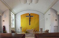
altar

Mural in the old nave

organ


Parish chapel St. Antonius: Estringen's membership in the parish of Lingen has been documented since 1250. The towerless Gothic chapel was built in 1520 according to an inscription above the south door; it probably had a previous building.
politics
The local council has eleven elected members. As a result of the local elections on September 11, 2011, it includes councilors from the CDU and SPD.
| Choice of location | 2006 | 2011 | ||||
|---|---|---|---|---|---|---|
| be right | Proc. | Seats | be right | Proc. | Seats | |
| CDU | 3280 | 84.95% | 9 | 3100 | 81.49% | 9 |
| SPD | 581 | 15.05% | 2 | 704 | 18.51% | 1 |
| voter turnout | 61.57% | 61.62% | ||||
Personalities
- Hans-Gerd Strube , politician (CDU), member of the Bundestag from 1983 to 1994
- Tamara Zieschang , politician (CDU), State Secretary in the Federal Ministry of Transport and Digital Infrastructure since 2019
literature
- Ernst Förstemann, Hermann Jellinghaus (editor) - Old German name book , Volume II, 1 and 2: Place names , Bonn 1913/1916 (Reprint: Volume II, 2, Hildesheim 1967/1983, ISBN 3-487-01733-4 )
- Hermann Abels - The place names of the Emsland, in their linguistic and cultural-historical significance , Ferdinand Schöningh Verlag, Paderborn 1929.
- Teachers' Association of the Diocese of Osnabrück - The District of Lingen. Contributions to local studies in the Osnabrück administrative district, volume I , R. van Acken publishing house, Lingen / Ems 1905.
- Werner Kaemling - Atlas on the history of Lower Saxony , Gerd J. Holtzmeyer Verlag, Braunschweig 1987, ISBN 3-923722-44-3 .
- Christoph Oberthür, Franz Busche, Franz Barth, Heinrich Dünheuft - home map of the Lingen district with statistical information , Verlag R. van Acken, Lingen / Ems 1953.
- Hans Behrens: Agricultural history board for Weser-Ems, data from 300 years of association work . Isensee Verlag, Oldenburg 2000, ISBN 3-89598-681-X .
- Statistics of the German Reich, results of various censuses, Berlin 1883–1944.
- Lower Saxony Office for State Planning and Statistics - Statistical Yearbook 1950 , Hanover 1950.
- Alfons Wolbers - St. Gertrudis parish in Bramsche, Heimatverein Lingen-Bramsche 2000, Helming printing company, 48488 Emsbüren.
- Helen Strube - The development of the elementary schools in Bramsche, Mundersum and Estringen, Heimatverein Lingen-Bramsche 1999, Goldschmidt-Druck GmbH, 49757 Werlte.
Individual evidence
- ↑ [1] stone grave Mundersumer, sand.
- ↑ [2] Great stone graves and tumuli Gleesen.
- ^ [3] Great stone graves and barrows Bramsche-Wesel.
- ↑ Helen Strube, Gestern und heute (The development of elementary schools in Bramsche, Mundersun and Estringen), Heimatverein Lingen-Bramsche, 1999, p. 45.
- ↑ Helen Strube, Gestern und heute (The development of elementary schools in Bramsche, Mundersun and Estringen), Heimatverein Lingen-Bramsche, 1999, p. 127.
- ↑ Helmut H. Boyer, Funde vom Lüberg, Yearbook of the Emsländischen Heimatbund, Vol. 30, 1984.
- ^ [4] Historical map of the counties of Lingen and Tecklenburg.
- ↑ [5] (PDF; 65 kB) Reformed History and Theology (Lesson 4: Reformed Confessionalization in Germany and Upper Germany), Georg Plasger, 2004.
- ↑ [6] History of the district of Lingen: The general story, R von Acken, pp. 218 and 223.
- ↑ [7] History of the former Meppen office in Münster by JB Diepenbrock, p. 371.
- ↑ Helen Strube, Gestern und heute (The development of elementary schools in Bramsche, Mundersun and Estringen), Heimatverein Lingen-Bramsche, 1999, p. 12.
- ^ History of the district of Lingen: The general story of R. von Acken, pp. 360 and 400.
- ^ Alfons Wolbers - St. Gertrudis parish in Bramsche.
- ^ [8] Military history in Lower Saxony and Bremen.
- ↑ Helen Strube, Gestern und heute (The development of elementary schools in Bramsche, Mundersun and Estringen), Heimatverein Lingen-Bramsche, 1999, p. 57.
- ↑ a b c Federal Statistical Office (ed.): Historical municipality directory for the Federal Republic of Germany. Name, border and key number changes in municipalities, counties and administrative districts from May 27, 1970 to December 31, 1982 . W. Kohlhammer GmbH, Stuttgart and Mainz 1983, ISBN 3-17-003263-1 , p. 255 and 256 .
- ↑ Archive link ( Memento of the original from December 18, 2007 in the Internet Archive ) Info: The archive link was automatically inserted and not yet checked. Please check the original and archive link according to the instructions and then remove this notice. Internet portal of the city of Lingen.
- ^ [9] Chronicle of the parish church of St. Gertrude.
- ↑ [10] Chronicle of the parish chapel St. Antonius.
- ↑ [11] Lingen.de Elections 2011.