
Fall River, Massachusetts
| Fall River | |
|---|---|
| Nickname : The Scholarship City, The Riv | |
 Downtown Fall River |
|
| Location in Massachusetts | |
 |
|
| Basic data | |
| Foundation : | 1670 |
| State : | United States |
| State : | Massachusetts |
| County : | Bristol County |
| Coordinates : | 41 ° 42 ′ N , 71 ° 9 ′ W |
| Time zone : | Eastern ( UTC − 5 / −4 ) |
| Residents : | 88,857 (as of 2010) |
| Population density : | 1,106.6 inhabitants per km 2 |
| Area : | 99.0 km 2 (approx. 38 mi 2 ) of which 80.3 km 2 (approx. 31 mi 2 ) are land |
| Height : | 40 m |
| Postcodes : | 02720, 02724 |
| Area code : | +1 508, 774 |
| FIPS : | 25-23000 |
| GNIS ID : | 0612595 |
| Website : | www.fallriverma.org |
| Mayor : | Jasiel F. Correia |
Fall River is a city (with the status "City" ) in Bristol County in the US -amerikanischen State Massachusetts . At the 2010 census , Fall River had 88,857 residents, making it the tenth largest city in Massachusetts.
geography
Fall River lies at 41 ° 42'5 "north latitude and 71 ° 9'20" west longitude and extends over 99 km², which is spread over 80.3 km² of land and 18.7 km² of water. The city is located at the confluence of the Taunton River in Mount Hope Bay , the northeastern part of Narragansett Bay . The southern city limit is also the state line with Rhode Island .
Neighboring towns to Fall River are Swansea (8.4 km northwest), Somerset (11.6 km north), Freetown (19.8 km northeast), North Westport (9.1 km southwest) and Tiverton in the neighboring state of Rhode Island (10th district) , 5 km southwest).
The closest major cities are New Bedford (14 miles east-southeast), Rhode Island's capital Providence (28.3 km northwest) and Massachusetts' capital Boston (87.1 km north).
traffic
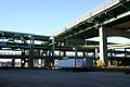
Fall River is the main transportation hub on Mount Hope Bay. Interstate 195 , US Highway 6 and Massachusetts Routes 24 , 79, 81 and 138 run through the urban area, some of which are motorway-like. In the south of the city, Massachusetts Route 177 crosses an approximately 100 m wide strip of the urban area.
The Brightman Street Bridge with US Highway 6 and the Charles M. Braga Jr. Memorial Bridge with Interstate 195 connect Fall River to the opposite northwest bank of the Taunton River.
Demographic data
| Population development | |||
|---|---|---|---|
| Census | Residents | ± in% | |
| 1810 | 1296 | - | |
| 1820 | 1594 | 23% | |
| 1830 | 4158 | 160.9% | |
| 1840 | 6738 | 62% | |
| 1850 | 11,524 | 71% | |
| 1860 | 14,026 | 21.7% | |
| 1870 | 26,766 | 90.8% | |
| 1880 | 48,961 | 82.9% | |
| 1890 | 74,398 | 52% | |
| 1900 | 104,863 | 40.9% | |
| 1910 | 110.295 | 5.2% | |
| 1920 | 120,485 | 9.2% | |
| 1930 | 115.274 | -4.3% | |
| 1940 | 115,428 | 0.1% | |
| 1950 | 111,963 | -3% | |
| 1960 | 99,942 | -10.7% | |
| 1970 | 96,898 | -3% | |
| 1980 | 92,574 | -4.5% | |
| 1990 | 92,703 | 0.1% | |
| 2000 | 91,938 | -0.8% | |
| 2010 | 88,857 | -3.4% | |
According to the 2010 census , Fall River had 88,857 people in 38,140 households. The population density was 1,106.6 people per square kilometer.
The racial the population was composed of 87.0 percent white, 3.9 percent African American, 0.3 percent Native American, 2.6 percent Asian and other ethnic groups; 2.8 percent were descended from two or more races. Hispanic or Latino of any race was 7.4 percent of the population.
Statistically, 2.30 people lived in each of the 38,140 households.
21.5 percent of the population were under 18 years old, 63.4 percent were between 18 and 64 and 15.1 percent were 65 years or older. 52.5 percent of the population was female.
The median income for a household was 34,236 USD . The per capita income was $ 20,337. 20.2 percent of the population lived below the poverty line.

Braga Bridge with Interstate 195
Intersection of Route 79 and Braga Bridge

Massachusetts Route 177
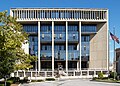
Fall River Government Center

Border City Mill, listed on the NRHP since 1983

Fall River Superior Court 1905

Plymouth Avenue

Kennedypark

Battleship Cove


sons and daughters of the town
- Jonathan Chace (1829-1917), politician
- Lizzie Borden (1860–1927), suspected and acquitted for the murder of her father and stepmother in 1892
- James Louis Connolly (1894–1986), Bishop of Fall River
- Aime Forand (1895–1972), politician
- Winston Sharples (1909–1978), composer
- Harry Wexler (1911–1962), meteorologist
- Nathan Bor (1913-1972), boxer
- Barbara W. Snelling (1928–2015), politician, Vice-Governor of Vermont from 1993 to 1997
- Robert Verity Clem (1933-2010), bird and landscape illustrator
- Joseph Patrick Delaney (1934-2005), Roman Catholic Bishop of Fort Worth
- Roc LaRue (1939-2019), rockabilly musician
- Greg Abate (* 1947), jazz musician (saxophone, flute), arranger and composer
- George Stephanopoulos (* 1961), journalist and political advisor
- Edward Pimental (1965–1985), soldier in the United States Army , murdered by RAF terrorists in Wiesbaden
- Michael DeMello (born 1974), actor
- Mindy Robinson (* 1980), actress and model
- Michelle Picard (* 1993), ice hockey player
Web links
Individual evidence
- ↑ a b c U.S. Census Bureau, State & County QuickFacts - Fall River, MA ( Memento of the original from March 5, 2012 in the Internet Archive ) Info: The archive link was automatically inserted and has not yet been checked. Please check the original and archive link according to the instructions and then remove this notice. Retrieved February 19, 2011
- ↑ All distances according to Google Maps. Accessed on February 19, 2012
- ↑ US Census 1850 (PDF; 11.0 MB) Retrieved February 19, 2012
- ↑ US Census 1870 (PDF; 7.4 MB) Retrieved February 19, 2012
- ↑ US Census 1880–1890 (PDF; 34.0 MB). Retrieved February 19, 2012
- ↑ US Census 1920 (PDF; 34.0 MB) Retrieved February 19, 2012
- ↑ US Census 1920–1950 (PDF; 29.1 MB). Retrieved February 19, 2012
- ↑ US Census 1940–1950 (PDF; 29.1 MB). Retrieved February 19, 2012
- ↑ US Census 1960–1980 (PDF; 5.9 MB). Accessed February 19, 2012
- ^ US Census 1990 (PDF; 10.7 MB) Retrieved February 19, 2012
- ↑ Extract from the National Register of Historic Places - No. 83004614.Retrieved February 19, 2011