Ferdinandov
| Ferdinandov | ||||
|---|---|---|---|---|
|
||||
| Basic data | ||||
| State : |
|
|||
| Region : | Liberecký kraj | |||
| District : | Liberec | |||
| Municipality : | Hejnice | |||
| Geographic location : | 50 ° 52 ' N , 15 ° 10' E | |||
| Height: | 410 m nm | |||
| Residents : | 276 (March 1, 2001) | |||
| Postal code : | 463 62 | |||
| License plate : | L. | |||
| traffic | ||||
| Street: | Hejnice - Ferdinandov | |||
Ferdinandov (German Ferdinandsthal ) is a district of the city of Hejnice in the Czech Republic . It is located two kilometers southwest of Hejnice and belongs to the Okres Liberec . The Stolpichstrasse ( Štolpišská silnice ) leads from Ferdinandov to the Jizera Mountains ridge .
geography
Ferdinandov lies at the northern foot of the Jizera Mountains at the transition to the Jizera Mountains foothills . The village extends on a ridge between the creeks Černý Štolpich ( Black Stolpich ) and Bílý Štolpich ( White Stolpich ), which unite at the lower end of the village to Sloupský potok and Štolpich ( Stolpichbach ). North rise the Na Chatkách (465 m) to the east, the Tišina ( Dresslerberg of, 873 m), Smrk ( Tafelfichte , 1124 m) and the Paličník (971 m) to the south-east Jizera ( Siechhübel , 1122 m) and the Ořešník ( Nussstein , 800 m), in the south the Holubník ( pigeon house , 1070 m) and the Ptačí vrchy ( Vogelkoppen , 1013 m), southwest of the Svinské čelo ( Saukuppen , 781 m) and the Poledník ( Mittagsberg , 864 m), in the west the Mlaka (450 m) and the Stržový vrch ( Grubberg , 704 m) and northwest of the Vapenný vrch (424 m).
Neighboring towns are Lužec in the north, Hejnice in the northeast, Bílý Potok in the east, Jizerka , Souš, Ničovy Domky and Černá Říčka in the southeast, Kristiánov and Nová Louka in the south, Na Pilách, Betlém, Oldřichov v Hájíchzi and Filipka in the southwest, Na Hráchzi West and V Lukách, Větrov , Raspenava and Luh to the northwest.
history
Ferdinandsthal was laid out between 1781 and 1783 by the owner of the Friedland estate , Christian Philipp von Clam-Gallas , on a desolate corridor between the two Stolpich brooks ( Schwarzer and Weißer Stolpich ) and named after his second son Ferdinand (* 1773).
In 1832 Ferdinandsthal , popularly called Papierdörfl , consisted of 74 houses with 419 German-speaking residents. There was a paper mill in the upper village. The parish was Haindorf . Until the middle of the 19th century Ferdinandsthal remained subject to the allodial rule Friedland .
After the abolition of patrimonial Ferdinandsthal formed from 1850 a district of the community Raspenau in the Bunzlauer Kreis and judicial district Friedland . From 1868 the village belonged to the Friedland district . In 1891 the construction of the Stolpichstrasse began; it originally served to improve the forestry development of the forests on the Jizera Mountains ridge and, after its completion as a connecting route over the ridge to Friedrichswald, also gained tourist importance. Since the beginning of the 20th century, Ferdinandsthal has developed into a summer resort . The Jägersteigbaude / Chata Myslivecká stezka , later Hotel Šárka, became a frequented place to stop for excursions. The Czech name Ferdinandov was introduced in 1924. After the Munich Agreement , it was incorporated into the German Reich in 1938; until 1945 Ferdinandsthal belonged to the Friedland district . After the end of World War II, Ferdinandov returned to Czechoslovakia and most of the German-Bohemian residents were expelled. The Stolpichstrasse was partially destroyed by the floods of 1958 and could no longer be used as a forest road. In 1960 Ferdinandov was reassigned to Hejnice; at the same time, the Okres Frýdlant was dissolved and the village was assigned to the Okres Liberec . After the Velvet Revolution , the restoration of Stolpichstrasse began; in 2000 the work was completed and the road was usable again for its original purpose.
In 1991 Ferdinandov had 290 inhabitants. In 2001 the village consisted of 127 houses in which 276 people lived. In total the place consists of 150 houses.
Local division
Ferdinandov belongs to the Hejnice cadastral district.
Attractions
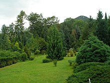
- Josef-Ebert-Arboretum on property no. 62, it was laid out in the 1950s by Josef Ebert (1935–1997) with local and foreign plants and is still owned by the Ebert family.
- Ořešník, the local mountain of the village
- Black and White Stolpich valleys with the Stolpich Falls
- Stolpichstraße, the serpentine mountain road was laid out in 1891 as a forest road.
- former watermill on the Smědá . It was operated from 1846 by the miller Franz Neumann. After 2000 it was converted into a hydroelectric power station.
- former watermill on Sloupský potok, it was built in 1871 by Ignaz Klause and is now used as a residential building.
- Bell tower
- Memorial plaque for Jára Cimrman at house number 21. It was unveiled in 1986 by Zdeněk Svěrák and Ladislav Smoljak and bears the inscription Zde byl v roce 1914 naposledy spatřen Jára da Cimrman ( Jára da Cimrman was last seen here in 1914 ).
Web links
Individual evidence
- ^ Johann Gottfried Sommer , Franz Xaver Maximilian Zippe The Kingdom of Böhmen, Vol. 2 Bunzlauer Kreis, 1834, p. 318
- ↑ http://www.czso.cz/csu/2009edicniplan.nsf/t/010028D080/$File/13810901.pdf
- ↑ http://www.liberecky-kraj.cz/dr-cs/4859-pametni-deska-jary-cimrmana.html


