Fort Tammhausen
The Fort Tammhausen was a fortification to protect the naval port of Wilhelmshaven .
location
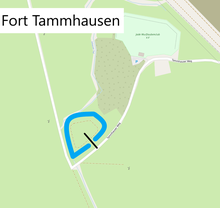
The fort was built as a closed lunette . The facility was designed for two platoons of infantry (~ 80 men). It is located southwest of the mound engruppe Tammhausen between Hooksiel and Voslapp . It is bordered by the Inhauser Tief in the north and west. The fort has a triangular plan and is oriented to the northwest. It is 130 meters long and 120 meters wide. The wall and the upstream graft are very well preserved. The wall is 10 to 20 meters wide and 1 to 2.5 meters high. The graft is 10 to 15 meters wide.
history
The exact construction time of the fort is not known. It must lie between the Franco-Prussian War of 1870/71 and the First World War . To the south of the fort was the Memershausen flak battery and the Idschenhausen battery, which were implemented as earth positions. The facility was reactivated in World War II and used as a flak position, from which remains of a concrete bunker are still preserved.
present
Due to its military-historical importance as an archaeological ground monument, the fort is a listed building.
literature
- Wulf: Archaeological monuments in the independent city of Wilhelmshaven. Material booklets on the prehistory and early history of Lower Saxony. 1996, p. 151.
- Land use plan for the area
Individual evidence
- ↑ a b c d e Friedhelm Wulf: Archaeological monuments in the independent city of Wilhelmshaven. In: Material booklets on the prehistory and early history of Lower Saxony . 1996, p. 151 .
- ^ Frank Gosch: fortress construction on the North Sea and Baltic Sea. The history of the German coastal fortifications until 1918 . 1st edition. Mittler, Hamburg / Berlin / Bonn 2003, ISBN 3-8132-0743-9 , pp. 51-64 .
- ^ Frank Gosch: fortress construction on the North Sea and Baltic Sea. The history of the German coastal fortifications until 1918 . 1st edition. Mittler, Hamburg / Berlin / Bonn 2003, ISBN 3-8132-0743-9 , pp. 51-64 .
Coordinates: 53 ° 36 '44.4 " N , 8 ° 3' 22.7" E


