
Fort Schaar

The Fort Schaar (Fort II) was as part of the fortress plan Wilhelmshaven's a fort to protect the Prussian naval base in Wilhelmshaven . It is located in the Aldenburg district near the Maade , just outside of today's Schaar district .
construction

The fort has a crescent-shaped floor plan. The length from southwest to northeast is 360 meters and width 210 meters. A wall and a graft up to 30 meters wide offer protection to the northwest. The original height of the wall can no longer be determined because it was built over, but there are remains with a height of up to 2 meters. The graft is still in good condition, it was only filled in the southeast.
history
The Maadeforts Rüstersiel , Mariensiel and Schaar were advertised on August 4, 1876 in the Wilhelmshavener Zeitung . The construction work was completed in 1880. Fort Mariensiel was connected to the forts Schaar and Rüstersiel by a newly built circumferential road; it was equipped with light rail tracks. The street ran on today's streets An der Vogelwarte, Dodoweg, Kurt-Schumacher-Straße. During the First World War, the Langewerth flak battery existed south of the fort and the Schaar-Mühle flak battery to the east, as well as the Kirchreihe flak battery. From the beginning of the Second World War until July 1942, Fort Schaar was the seat of the air defense command and the air watch command. It was also the seat of the commandant in the Wilhelmshaven section. From January 6, 1943 it was used by the 3rd Italian Fog Battalion as a command post.
The fort was primarily used for the training of naval artillerymen, but was also fully operational during the First World War. After the Second World War, the 8-hectare site was privately owned until 1974. There were considerations to use it as a campsite or as a leisure area. In 1974, however, it was built on with single-family and row houses. Outside the actual fort, numerous remains of the fort's fortifications can be found directly at the graft.
Armament
The fort was initially armed with nine 15 cm L / 22 cannons and nine 12 cm cannons.
photos
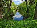
Eastern part of the graft

Northern part of the graft

Information board at the entrance

Information board


Web links
Individual evidence
- ↑ a b c Werner Brune: Wilhelmshavener Heimatlexikon KR . Ed .: Werner Brune. tape 2 , 1987, pp. 640 .
- ^ Wulf: Archaeological monuments in the independent city of Wilhelmshaven. Material booklets on the prehistory and early history of Lower Saxony . 1996.
- ^ Frank Gosch: fortress construction on the North Sea and Baltic Sea. The history of the German coastal fortifications until 1918 . 1st edition. Mittler, Hamburg / Berlin / Bonn 2003, ISBN 3-8132-0743-9 , pp. 51-64 .
- ^ Frank Gosch: fortress construction on the North Sea and Baltic Sea. The history of the German coastal fortifications until 1918 . 1st edition. Mittler, Hamburg / Berlin / Bonn 2003, ISBN 3-8132-0743-9 , pp. 51-64 .
- ^ Friedrich August Greve: The air defense in the Wilhelmshaven section 1939-1945. 2nd Navy Flak Brigade . Hermann Lüers, Jever 1999, ISBN 3-9806885-0-X , p. 10 .
- ^ Wilhelmshavener Heimatlexikon SZ . S. 35 .
- ^ Frank Gosch: fortress construction on the North Sea and Baltic Sea. The history of the German coastal fortifications until 1918 . 1st edition. Mittler, Hamburg / Berlin / Bonn 2003, ISBN 3-8132-0743-9 , pp. 51-64 .
Coordinates: 53 ° 32 ′ 32.6 ″ N , 8 ° 4 ′ 22 ″ E