
Gmina Cedry Wielkie
| Gmina Cedry Wielkie | |||
|---|---|---|---|

|
|
||
| Basic data | |||
| State : | Poland | ||
| Voivodeship : | Pomerania | ||
| Powiat : | Gdańsk | ||
| Geographic location : | 54 ° 15 ' N , 18 ° 51' E | ||
| Residents : | 1255 (March 31, 2011) | ||
| Postal code : | 83-020 | ||
| Telephone code : | (+48) 58 | ||
| License plate : | GDA | ||
| Economy and Transport | |||
| Street : | S7 Danzig – Koszwały | ||
| Next international airport : | Danzig | ||
| Gmina | |||
| Gminatype: | Rural community | ||
| Gmina structure: | 13 school authorities | ||
| Surface: | 124.28 km² | ||
| Residents: | 6947 (June 30, 2019) |
||
| Population density : | 56 inhabitants / km² | ||
| Community number ( GUS ): | 2204022 | ||
| Administration (as of 2010) | |||
| Wójt : | Janusz Stefan Goliński | ||
| Address: | ul.Macieja Płażyńskiego 16 83-020 Cedry Wielkie |
||
| Website : | www.cedry-wielkie.pl | ||

The Gmina Cedry Wielkie is a rural community in Powiat Gdański in the Polish province of Pomerania . It has an area of 124.3 km², on which 6947 people live (June 30, 2019). Their seat is the village of the same name ( German Groß Zünder , Kashubian Wiôldżé Cedrë ).
geography
_location_map.png)
Cedry Wielkie is located in Pomerania , about 15 kilometers east of Pruszcz Gdański (Praust) and 20 kilometers southeast of Gdansk . The municipality borders the city of Gdansk and the rural municipalities of Ostaszewo (Schöneberg) , Pruszcz Gdański (Praust) , Stegna (Steegen) and Suchy Dąb (Zugdam) .
The rural community is located in the Żuławy Wiślane (Vistula-Nogat Delta) , and its area is characterized by land reclamation and drainage measures. Canals and drainage ditches are part of the landscape. The Vistula forms the eastern border of the municipality, the Dead Vistula part of the northern border to Wyspa Sobieszewska , which belongs to the city of Gdansk. Part of the western border is formed by the Motława River . 82 percent of the area is used for agriculture, there is no forest.
history
With the First Partition of Poland , the municipality became part of the Kingdom of Prussia and the Province of West Prussia in 1772 . Due to the provisions of the Versailles Treaty , the area fell to the Free City of Danzig after the First World War in 1920 .
In the wake of World War II , West Prussia came to Poland . The local population was displaced .
From 1975 to 1998 the rural community was part of the Gdansk Voivodeship .
Community structure
Schulzenämter
The rural community of Cedry Wielkie has thirteen districts, each with a Schulzenamt .
| Polish name | German name (until 1945) |
Pop. (2006) |
location | image |
|---|---|---|---|---|
| Błotnik | Pain block | 344 | (Location) |
.jpg)
|
| Cedry Małe | Small detonator | 927 | (Location) |

|
| Cedry Wielkie | Big detonator | 1007 | (Location) |

|
| Długie Pole | Langfelde | 584 | (Location) |

|
| Giemlice | Gemlitz | 253 | (Location) |

|
| Kiezmark | Cheese mark | 370 | (Location) |

|
| Koszwały | Gottswalde | 828 | (Location) |
.jpg)
|
| Leszkowy | Letzkau | 273 | (Location) |
.jpg)
|
| Miłocin | Herzberg | 253 | (Location) |

|
| Stanisławowo | Schönau | 182 | (Location) |

|
| Trutnowy | Trutenau | 1100 | (Location) |

|
| Trzcinisko | Schönrohr | 223 | (Location) |

|
| Wocławy | Wotzlaff | 305 | (Location) |
.jpg)
|
Other localities
_-_panoramio.jpg)
The rural community includes four other localities without a Schulzenamt.
| Polish name | German name (until 1945) |
Pop. (2006) |
location | Schulzenamt |
|---|---|---|---|---|
| Miłocin Drugi | " Miłocin Two " | 230 | (Location) | Koszwały |
| Ostatni Grosz | New pound | ? | (Location) | Koszwały |
| Serowo | - | 370 | (Location) | Kiezmark |
| Szerzawa | Breitfelde | ? | (Location) | Trzcinisko |
Listed sights
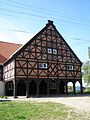
- Three special porch houses in Koszwały (1792), Miłocin (1730) and Trutnowy (1720) are listed as historical monuments.
- Parish Church in Cedry Wielkie, 14th century
- Parish church in Giemlice, 1840/41
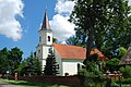
- Parish church in Kiezmark, 1727, cemetery
- Church (14th – 16th, 19th centuries), churchyard with old trees in Leszkowy
- Parish church in Trutnovy, 14th and 17th centuries; old graves
- Rectory in Trutnovy, 1728
- Church ruins in Wocławy, 14th century and 1730
- Deichmeisterei near Kiezmark, wooden house.
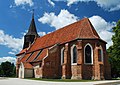
Church in Cedry Wielkie
Church in Giemlice

Church in Kiezmark

Church in Leszkowy

Porch house in Koszwały
Front house in Miłocin

House in Trutnovy

Deichmeisterei near Kiezmark


.jpg)


_ed.jpg)

traffic
The S7 expressway leads from Gdańsk to Koszwały. In 2012, Błotnik received a modern marina for 120 boats.
Personalities
- Franz Doerksen (* 1860 in Groß Zünder; † 1930) member of the German Reichstag
- Bernhard von Wiecki (* 1884; † 1940 in Stutthof concentration camp ) priest in Wotzlaff and victim of violence by the Catholic Church.
Web links
Footnotes
- ^ CIS 2011: Ludność w miejscowościach statystycznych według ekonomicznych grup wieku (Polish), March 31, 2011, accessed on June 27, 2017
- ↑ population. Size and Structure by Territorial Division. As of June 30, 2019. Główny Urząd Statystyczny (GUS) (PDF files; 0.99 MiB), accessed December 24, 2019 .
- ↑ The Historical Place Directory
- ↑ West Prussian index of places (accessed April 17, 2018)
- ^ Catalog zabytków sztuki. Tom V, Zeszyt 1, Pruszcz Gdański i okolice . Wydawnictwa Artystyczne i Filmowe, Warszawa 1986.
Municipality: Pruszcz Gdański (Praust) . Rural parishes : Cedry Wielkie (Groß Zünder) | Kolbudy (Ober Kahlbude) | Pruszcz Gdański (Praust) | Przywidz (Mariensee) | Pszczółki (Hohenstein) | Suchy Dąb (Zugdam) | Trąbki Wielkie (Great Hitchhiking) .