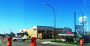
Grand Rapids, Minnesota
| Grand Rapids | |
|---|---|
 |
|
| Location of the city in County and Minnesota | |
| Basic data | |
| Foundation : | 1872 |
| State : | United States |
| State : | Minnesota |
| County : | Itasca County |
| Coordinates : | 47 ° 14 ′ N , 93 ° 32 ′ W |
| Time zone : | Central ( UTC − 6 / −5 ) |
| Residents : | 10,869 (as of 2010) |
| Population density : | 1,488.9 inhabitants per km 2 |
| Area : | 8.1 km 2 (about 3 mi 2 ) of which 7.3 km 2 (about 3 mi 2 ) are land |
| Height : | 392 m |
| Postcodes : | 55730, 55744, 55745 |
| Area code : | +1 218 |
| FIPS : | 27-25118 |
| GNIS ID : | 0656428 |
| Website : | grandrapids.govoffice.com |
| Mayor : | Dale Adams |
Grand Rapids is a city (with the status " City ") and the administrative seat of Itasca County in the US -amerikanischen State Minnesota . In 2010 , Grand Rapids had 10,869 residents.
geography
The city is located northeast in the state on the edge of the Mesabi Range . Duluth is about 125 kilometers southeast of Grand Rapids, the major cities of Minneapolis-St. Paul are about 273 kilometers away. The Mississippi River flows through the city . According to the United States Census Bureau , the area of the city is 8.1 square kilometers, of which 0.8 square kilometers is water.
history
Grand Rapids originated as a logging village in the 1870s. The first permanent building was built in 1872. On June 11, 1891, Grand Rapids became a village and received city rights in 1957. Since November 8, 1892, it has been the administrative seat of Itasca County.
The name Grand Rapids was derived from the rapids of the Mississippi that flows through Grand Rapids. Today the rapids lie below the dam of the Blandin paper mill. This paper mill, now run by UPM , is a major employer in Grand Rapids.
Demographic data
| Population development | |||
|---|---|---|---|
| Census | Residents | ± in% | |
| 1900 | 1428 | - | |
| 1910 | 2230 | 56.2% | |
| 1920 | 2914 | 30.7% | |
| 1930 | 3205 | 10% | |
| 1940 | 4875 | 52.1% | |
| 1950 | 6019 | 23.5% | |
| 1960 | 7265 | 20.7% | |
| 1970 | 7247 | -0.2% | |
| 1980 | 7934 | 9.5% | |
| 1990 | 7976 | 0.5% | |
| 2000 | 7764 | -2.7% | |
| 2010 | 10,869 | 40% | |
| 1900-2000 2010 | |||
According to the 2010 census , Grand Rapids lived 10,869 people in 4,615 households. The population density was 1488.9 inhabitants per square kilometer. Statistically, 2.2 people lived in each of the 4615 households.
The racial the population was composed of 94.6 percent white, 0.6 percent African American, 1.9 percent Native American, 0.6 percent Asian and 0.3 percent from other ethnic groups; 2.0 percent were descended from two or more races. Hispanic or Latino of any race was 1.2 percent of the population.
22.2 percent of the population were under 18 years old, 57.0 percent were between 18 and 64 and 20.8 percent were 65 years or older. 52.5 percent of the population was female.
The average annual income for a household was 41,931 USD . The per capita income was $ 25,278. 10.8 percent of the population lived below the poverty line.
sons and daughters of the town
- Judy Garland (1922–1969), film actress and singer
- Rick Hill (born 1946), politician
- Buzz Schneider (* 1954), ice hockey player
- Bill Baker (born 1956), ice hockey player
- Jeff Nielsen (born 1971), ice hockey player
- Steve Wagner (* 1984), ice hockey player
- Alex Goligoski (* 1985), ice hockey player
- Mark Johnson (b.1987), biathlete
Individual evidence
- ↑ a b c American Fact Finder. Retrieved April 28, 2013
- ^ US Decennial Census. Retrieved April 28, 2013
