
Chicken field (moor)
Coordinates: 51 ° 21 ′ 58 ″ N , 9 ° 40 ′ 30 ″ E


The chicken field in the southern Lower Saxony district of Göttingen ( Germany ) is an intermediate moor in the Kaufungen Forest . In the southernmost moor in Lower Saxony there are endangered plant species such as round-leaved sundew , Schnabelried and scabbard cotton-grass . The name is derived from Hünenfeld , which used to refer to an open area in the mountainous region.
geography
location

The chicken field extends in the north-western part of the Kaufunger Forest, which is occupied by the southern part of the Münden Nature Park . It lies between the Kleiner Steinberg ( 541.9 m above sea level ) in the east and the Hühnerfeldberg ( 418.4 m ) in the west. About 3 km (as the crow flies ) northeast of Sichelnstein , a district of Staufenberg , it is between 380 and 460 m altitude. A small tributary of the Schwarzbach rises in the Hühnerfeld, which flows into the Nieste tributary Ingelheimbach . The landgrave fountain and a water tank are located on its eastern edge .
Natural allocation
The chicken field belongs to the natural spatial main unit group Osthessisches Bergland (No. 35), in the main unit Fulda-Werra-Bergland (357) and in the subunit Kaufunger Wald and Söhre (357.7) to the natural area Kaufunger Wald-Hochfläche (Vorderer Kaufunger Wald) (357.71 ).
Moor description
The chicken field is a large mountain meadow area with a high moor character. It formed due to the climate and soil conditions. The precipitation is considerable and can hardly seep into the red sandstone subsoil. Since the Middle Ages, the area has been shaped by centuries of use as cattle herding . At the end of the 18th century at the Kurhannoversche Landesaufnahme , the chicken field was twice as large as it is today. Since the use of hats was abandoned in the middle of the 20th century, whistle grass , wiryweed and bracken have increasingly spread . One of the rarer plants is arnica , also known as locust flower or Wohlverleih.
After the Second World War , forestry wanted to operate profitable silviculture in the chicken field and began to drain the area with ditches. In the mid-1950s, the head of the forestry faculty at the University of Göttingen campaigned for the preservation of the chicken field in its original state. He suggested placing it under protection as a nature reserve, which took place in 1968 (see Section Protected Areas ). Since 1992 it has been grazed extensively with Icelandic horses on behalf of the district of Göttingen and since 2006 with suckler cows. This grazing helps to preserve endangered plant species of the arboreal grass lawns and Kleinseggenrieder .

Bog area with birch trees
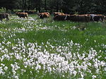
Cattle in the chicken field with fruiting cotton grass
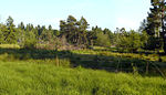
Typical pasture in the chicken field
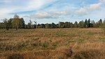
View from the Bohlenweg in the Hühnerfeld to the northeast


Protected areas
The chicken field was designated as a nature reserve (NSG) Hühnerfeld ( CDDA No. 81952; 52 hectares ) in 1968 . In June 2018 it went up in the newly designated Bachtäler nature reserve in the Kaufunger Forest . The area is part of the fauna-flora-habitat area Bachtäler in the Kaufunger Forest (FFH no. 4623-331; 12.98 km²). Immediately surrounding the NSG is mostly from the conservation area Weserbergland Kaufunger Forest (CDDA No. 325317;. 1989 285.02 square kilometers ), south-west it borders on the nature reserve "Kaufunger forest".
Traffic and walking


The chicken field, for example, can be reached via the Hann. Munden / Lutterberg the Federal Highway 7 incipient county road 222 and one of these branches off before Sichelnstein toward the east-northeast side road that pass the Hühnerfeld to achieve through the Kaufunger forest. Via the coal road , which branches off from the side road at the northern end of the Hühnerfelds , where there is a parking lot for hikers , you can get to the Hühnerfeldberg , the Kleiner Steinberg and the Naturfreundehaus Steinberg am Großer Steinberg .
Entering the chicken field is not allowed. It is only allowed to hike through the boardwalk, which was completed in 2015 and runs across the area . The 1.2 meter wide path with a viewing platform roughly in the middle of the path runs in the southern part of the landscape roughly in a west-east direction along the pasture area on a gradient of around 11%. The official inauguration of the project, which is funded with 40,000 euros, is to take place in the course of 2015. In addition, the chicken field can be walked around directly on paths and trails running along its edge. The Frau-Holle-path leads directly to the east along the coal road and thus past the moorland .
literature
- Ernst Andreas Friedrich : Natural monuments of Lower Saxony . Hanover, 1980. ISBN 3-7842-0227-6
Web links
- Grazing a hat landscape with horses and cattle: the "chicken field" , on geobotanik.uni-goettingen.de (PDF file; 311.9 kB)
Individual evidence
- ↑ a b Map services of the Federal Agency for Nature Conservation ( information )
- ↑ On planks through protected moorland , dated July 11, 2012, accessed on March 22, 2015, on hna.de.
- ↑ New attraction for hikers: Auf Planken through the moor , from March 3, 2015, accessed on March 22, 2015, on hna.de.
- ↑ Bohlenweg over the Hühnerfeldmoor , from November 19, 2014, accessed on February 11, 2015, on naturparkmagazin.de
- ↑ Map of the chicken field , information board at the hikers' car park on Kohlenstraße , on commons.wikimedia.org