Hasselbach (Dalke)
| Hasselbach | ||
|
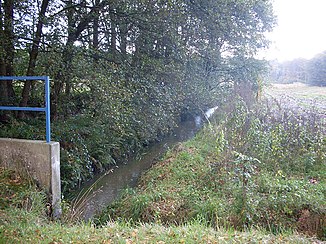
The Hasselbach in the NSG Hasselbachaue |
||
| Data | ||
| Water code | EN : 3124 | |
| location | North Rhine-Westphalia , Germany | |
| River system | Ems | |
| Drain over | Dalke → Ems → North Sea | |
| source | In the Bielefeld district of Eckardtsheim 51 ° 56 ′ 35 ″ N , 8 ° 33 ′ 18 ″ E |
|
| Source height | approx. 118 m above sea level NN | |
| muzzle | North of Verl in the Dalke coordinates: 51 ° 54 '43 " N , 8 ° 29' 56" E 51 ° 54 '43 " N , 8 ° 29' 56" E |
|
| Mouth height | approx. 90 m above sea level NN | |
| Height difference | approx. 28 m | |
| Bottom slope | approx. 4.4 ‰ | |
| length | 6.3 km | |
| Catchment area | 10.968 km² | |
| Left tributaries | Grenzbach transmitter | |
| Communities | BI-Eckardtsheim , Gütersloh and Verl | |
The Hasselbach is an orographically right tributary of the Dalke in North Rhine-Westphalia , Germany . It has a length of 6.3 km. The route of this near-natural Sennebach leads largely through nature reserves .
River course
The Hasselbach rises 118 meters north of Eckardtsheim , a district in the Sennestadt district of the independent city of Bielefeld , and flows in a south-westerly direction following the flattening of the Teutoburg Forest . Just a few meters behind the source, the water enters the Hasselbachaue nature reserve and within this area passes under the federal motorway 2 . In the further course of the Hasselbachaue, several ponds are fed and shortly before the transition to the city of Verl and thus also to the district of Gütersloh, next to the small Grenzbach transmitter, two more spring pots are added.
The protected area of the Bachaue ends with the district boundary. After a short stretch of river through Verl, the Hasselbach enters the area of the city of Gütersloh and there, the Große Wiese, reaches another area designated as a nature reserve. Within this extensive grassland area, partly criss-crossed by hedges and trees, the Hasselbach flows into the Dalke, again just under Verler area.
The water overcomes a height difference of 28 meters during its flow path, resulting in an average bed gradient of 4.4 ‰.
Hasselbachaue
The floodplain, through which the Hasselbach flows and is designated as a protected area, has a total area of 51.9 hectares and consists primarily of wet meadows , stocks of reed plants and alder forests . Characteristic is also a forest of bird cherry, alder and ash tree, as well as a remnant of drifting sand dune with heather and sandy grassland .
Web links
- Nature reserve "Hasselbach (Dalke)" (BI-013) in the specialist information system of the State Office for Nature, Environment and Consumer Protection in North Rhine-Westphalia

