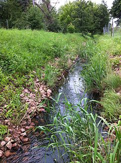
Hechtgraben (Saale)
| Hechtgraben | ||
| Data | ||
| location | State of Saxony-Anhalt , north of Halle | |
| River system | Elbe | |
| Drain over | Saale → Elbe → North Sea | |
| source |
Dölau 51 ° 30 ′ 32 ″ N , 11 ° 53 ′ 37 ″ E |
|
| muzzle |
Hall coordinates: 51 ° 31 ′ 27 " N , 11 ° 55 ′ 8" E 51 ° 31 ′ 27 " N , 11 ° 55 ′ 8" E
|
|
| length | 3 km | |
| Left tributaries | Haßgraben (mouth: 51 ° 31 ′ 11.9 ″ N , 11 ° 55 ′ 10.9 ″ E ) and Schachtgraben (mouth: 51 ° 30 ′ 41 ″ N , 11 ° 54 ′ 1.4 ″ E ) | |
| Big cities | Halle (Saale) | |
The Hechtgraben is a left tributary of the Saale . The ditch has its origin in the Dölau district of the city of Halle (Saale) . It is approx. 3 kilometers long, with a left tributary almost 4 kilometers long, first flowing through Dölau in an easterly direction and the Heide-Nord / Blumenau district and then flowing northwards into the Saale. The Hechtgraben flow left or north to the west of Halle-Nord / Blumenau of Schachtgraben , from the north Dölaus coming, and just before the mouth of the Haßgraben , coming from Latvian to. In the upper reaches, the ditch does not carry water all year round.
literature
- Hallesche Auenwälder working group (AHA): Framework plan Hechtgraben (PDF: 76 KB) . Last accessed on June 21, 2020.
Web links
- Environmental Atlas Halle . Last accessed on June 21, 2020.
- Working group Hallesche Auenwälder (AHA): Hechtgraben and Hassgraben in Halle . Last accessed on June 21, 2020.
Individual evidence
-
↑ The length of the Hechtgraben of 3.0 km was measured in the
Saxony-Anhalt Viewer of the State Office for Surveying and Geoinformation ( notes )
from the origin of the named Hechtgraben in Dölau immediately northeast of the Otto-Kanning-Straße / Heideweg intersection, as shown on the map . Already after 140 meters it flows into a trickle from the left, which rises 1.0 km west-northwest of it at Kirchweg and Stadtforststraße .
