Jomalig
| Municipality of Jomalig | ||
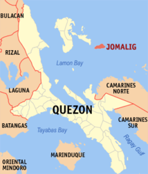
| Location of Jomalig in the Quezon province | ||
|---|---|---|

|
||
| Basic data | ||
| Region : | CALABARZON | |
| Province : | Quezon | |
| Barangays : | 5 | |
| District: | 1. District of Quezon | |
| PSGC : | 045621000 | |
| Income class : | 5th income bracket | |
| Households : | 1032 May 1, 2000 census
|
|
| Population : | 7,417 August 1, 2015 census
|
|
| Population density : | 143.5 inhabitants per km² | |
| Area : | 51.7 km² | |
| Coordinates : | 14 ° 42 ' N , 122 ° 23' E | |
| Postal code : | 4342 | |
| Geographical location in the Philippines | ||
|
|
||
Jomalig is a Philippine municipality in the province of Quezon . It has 7,417 inhabitants (August 1, 2015 census).
The area of the municipality of Jomalig is essentially identical to the island of Jomalig of the same name , which is part of the Polillo archipelago and is located in the north of the Bay of Lamon , a side water of the Philippine Sea .
Barangays
Jomalig is politically in five barangays divided.
- Buccal
- Casuguran
- Gango
- Talisoy (Pob.)
- Apad
