San Narciso (Quezon)
| Municipality of San Narciso | ||
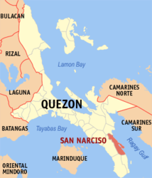
| Location of San Narciso in the Quezon province | ||
|---|---|---|

|
||
| Basic data | ||
| Region : | CALABARZON | |
| Province : | Quezon | |
| Barangays : | 24 | |
| District: | 3. District of Quezon | |
| PSGC : | 045644000 | |
| Income class : | 3rd income bracket | |
| Households : | 7845 May 1, 2000 census
|
|
| Population : | 48,461 August 1, 2015 census
|
|
| Population density : | 240 inhabitants per km² | |
| Area : | 201.9 km² | |
| Coordinates : | 13 ° 34 ' N , 122 ° 34' E | |
| Postal code : | 4313 | |
| Geographical location in the Philippines | ||
|
|
||
San Narciso is a municipality in the Province of Quezon, Philippines . It has 48,461 inhabitants (August 1, 2015 census). The municipality is located on the Bondoc peninsula , on the coast of the Gulf of Ragay .
Barangays
San Narciso is politically divided into 24 barangays .
|
|
Web links
- elgu2.ncc.gov.ph - San Narciso ( Memento of November 4, 2007 in the Internet Archive )
