California (historical landscape)
California ( Spanish California ) originally referred to a landscape in North America that included the northwestern part of the Spanish colonial possessions in America , which Mexico fell to after its independence. The northern part of this landscape has its center of gravity in what is now the US state of California in the western United States , whose eastern border has only been precisely defined since 1850. It was called Upper California until the middle of the 19th century (Spanish Alta California , English Upper California ). The southern part of the historic landscape is the peninsula Baja California (Span. Baja California , Eng. Lower California ) and today meets the Mexican states of Baja California and Baja California Sur .
History and Development
prehistory
The first traces of human settlement were found in Paleo-Indian times around 9000 to 10,000 BC. On today's Channel Islands . Already before 8000 BC Small groups hunted game, mountain sheep and birds and fished. There was also the collection of acorns and wild grasses. Agriculture and basketry were well developed by some groups.
Voyages of discovery
The first European explorers sailed off the coast of California from the early 16th century. Their ships sailed under the flags of Spain and England . The most important colonial power, Spain, focused on its territories in Mexico , Peru and the Philippines . But the Spaniards sought to extend their power to the coastlines of the whole Pacific, which also turned their attention to California. Securing the Manila galleons , i.e. the trade between the Southeast Asian and American possessions of Spain, played an important role. However, to the explorers, the area appeared only as rolling grassland, which was unattractive for colonization. Little did they know that California's gold deposits would have surpassed their imagination of an Eldorado . Spanish colonization did not begin until the 18th century, and at the beginning of the 19th century Russian fur traders founded the Fort Ross base .
Hernán Cortés
Around 1530, the then President of the Audiencia of New Spain , Nuño Beltrán de Guzmán . tells of a slave from the Seven Cities , the streets of which are paved with gold and silver . Around the same time, Hernán Cortéz heard reports of a wonderful country in the northwest, populated by Amazons , and where gold, pearls and precious stones were in abundance.
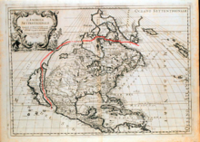
In 1533 Cortéz discovered a bay, probably that of La Paz , before which difficulties forced him to return. He undertook further expeditions in 1534 and 1535, but without finding the land he was looking for. Eventually he claimed Isla de Santa Cruz (now Baja California ) for Spain and founded a city that would later be named La Paz. For a long time California was thought to be an island off the American continent ( Island of California ).
Francisco de Ulloa
In July 1539, Cortéz, driven by recent fabulous stories, sent Francisco de Ulloa with three small ships. He reached the mouth of the Colorado River and sailed around the peninsula to Cedros . However , he did not find the Strait of Anián , which de Ulloa also hoped to find; on the contrary, he found indications that California was only a peninsula.
Juan Rodríguez Cabrillo

The first European to tour the California coast was Juan Rodríguez Cabrillo, a Spanish captain who set sail for the Spanish crown. He had set out from the west coast of Mexico and went ashore on September 28, 1542 in the Bay of San Diego and had taken possession of the "island" of California for Spain.
While trying to continue the journey north to find the overland route to Asia, Cabrillo had an accident and was killed. Bartolomé Ferrelo , who came roughly to the mouth of the Rogue River in southern Oregon , became the commander in his place . For the indigenous population, the Cabrillos expedition may have meant a sharp drop in population numbers due to smallpox introduced.
Sir Francis Drake
On June 7th, 1579, the English explorer Sir Francis Drake discovered a port that he thought was very suitable for anchoring. He named the place Nova Albion . It is no longer known where this port was located. A stone slab found in 1936, which reported this landing, turned out to be a forgery. Nevertheless, from now on all English maps called the area north of Baja California, New Granada and New Mexico "Nova Albion".
Sebastián Vizcaíno
Other explorers such as Pedro de Unamuno (1587) and Sebastian Rodriquez Cermeno (1595) explored the coast. In 1602, the Spaniard Sebastián Vizcaíno circumnavigated the California coastline to the Bay of Monterey , where he went ashore. He was traveling south along the coast and presumably reached Carmel . He gained importance for the history of the state through his travel reports, which particularly showed the area around Monterey as very suitable for settlement, but also through his detailed maps of the coastal areas, which were used for almost two hundred years.
Spanish colonization
The colonization of California was finally decided by the Spanish king at the end of the 17th century and entrusted to the Jesuits , who, on condition that the royal authority was recognized, also held all secular authority on the California territory, in particular the sovereignty over the Spanish troops accompanying them.
Through missionary work , the Baja California peninsula was colonized by the Jesuits. The first mission and settlement that existed was built by them in 1697 in central Lower California ( Loreto ). The mission settlement was expanded to become the “capital” of California, and further missions were founded in Baja California. It is Eusebio Kino particularly noteworthy.
The later Alta California (Upper California) moved into the center of Spanish colonial policy in 1769 with the establishment of a mission in what is now San Diego (de Alcalá).
In 1774, Capitano Juan Bautista de Anza moved from Tucson , Arizona, across the Colorado River at Yuma and on to the Pacific Ocean. He advanced along the coast to San Francisco Bay , where he founded the Presidio San Francisco military base . His companions from the Order of the Franciscans , who had taken on proselytizing after the Jesuit ban, founded the neighboring San Francisco de Asís Mission . The Pueblo de San José settlement was built for the farmers who traveled with them . In the following years three military bases were established in Monterey , Santa Barbara and San Diego, from which the province was subsequently administered. They were initially assigned a mission station and a pueblo. In the following years, more missions and pueblos emerged, and the Spaniards established a total of 21 missions in California. They were all connected by El Camino Real , the royal road that ran along the coast.
In 1781, the Yuma Indians destroyed the San Pedro y San Pablo de Bicuñer Mission in Arizona, thereby breaking the road connection between Mexico and California. The connection was never restored in Spanish times, since then the province has only been accessible by sea. Due to the prevailing wind directions, the trip from Mexico to San Diego or further north often took three months, which is why the connection of the province to the viceroyalty of New Spain was only loose.
In 1804, California was divided into two administrative areas, northern Upper and southern Baja California . In the Mexican War of Independence from 1810 to 1821, the Mexicans achieved independence from Spain, but at a very high price.
Secession from Upper California
During the Mexican-American War , the northern part was occupied by the USA in 1846 and then left to the USA with the Treaty of Guadalupe Hidalgo in 1848 ; until 1857 there were plans to annex the southern part. Soon afterwards, the part that remained with Mexico was divided into the areas of Baja California and Baja California Sur, which still exist today.
After the separation, US Upper California and Mexican Baja California developed independently of each other. Upper California saw a real population explosion due to the gold rush , among other things , while the south as well as the neighboring Sonora in the east continued to represent a sparsely populated peripheral zone of Mexico. So it happened that the north gradually renounced the "upper" and bears the name "California" alone. Also in Spanish today, “California” primarily refers to the US state, not the historical landscape.
During the Mexican Revolution , Baja California was the operational area of the Partido Liberal Mexicano (PLM). The short-term conquest of Baja California by the PLM initially triggered new speculations about an annexation by the United States. Governor Esteban Cantú used the turmoil of the following years to build up a position of power that was completely independent of the weak Mexican central government, which he was able to maintain from 1915 to 1920. With the resurgence of central power in Mexico, Baja California's de facto independence came to an end . After all attempts to persuade Cantú to voluntarily surrender power had failed, the Mexican federal government set in motion an expeditionary force to recapture Baja California. In view of the hopeless military situation for him, Cantú finally gave up and went into exile in the US in August 1920.
present
The uneven population development of the two California states has practically continued to this day. The US state is constantly growing in population. Baja California, on the other hand, is one of the most sparsely populated regions of Mexico, except for the suburbs directly bordering (Upper) California with the metropolises of Tijuana and Mexicali , which has only recently been due to tourism (also through Hollywood films, for example the final scene in Terminator 1 ) experienced a kind of boom. Especially the southern tip with Cabo San Lucas and San José del Cabo has developed into a very popular holiday destination for Americans and Canadians in recent years.
Nevertheless, both California share the largely desert-like landscape with high mountains in the immediate vicinity of the coast. In deserted Baja California you can get an idea of what the now practically completely populated coastal landscape of California must have looked like 200 years ago.
politics
During the period of Spanish and Mexican rule over California, a governor was entrusted with the political leadership of the country. Until 1822 all governors of both California ("Las Californias") and then of Alta California were Spaniards. In 1822, Luis Antonio Argüello was the first man born in America to become governor of California.
Web links
- California Historical Society (English)
- California History Timeline ( February 3, 2010 memento on the Internet Archive )
Individual evidence
- ↑ In the Daisy Cave, in the north of the Channel Islands, among other things, remains from the time around 10,300-9100 BC were found. See Torben C. Rick, Jon M. Erlandson & Rene L. Vellanoweth: Paleocoastal Marine Fishing on the Pacific Coast of the Americas: Perspectives from Daisy Cave, California. In: American Antiquity 66/4 (2001) pp. 595-614.
- ↑ The site is the Arlington Spring Site in Arlington Canyon , which Orr discovered in 1959. See Phil C. Orr: The Arlington Spring Site, Santa Rosa Island, California. In: American Antiquity 27/3 (January 1962), pp. 417-419. See also: John R. Johnson: Ancient Bones May Rewrite History , Santa Barbara Museum of Natural History ( Memento from March 9, 2009 in the Internet Archive )
- ^ US National Park Service official website about Juan Cabrillo. (accessed December 18, 2006)
- ↑ Jon M. Erlandson, Torben C. Rick, Douglas J. Kennett, and Phillip L. Walker: Disease: Cultural Contacts and Possible Evidence for Old World. Epidemics Among the Protohistoric Island Chumash. In: Pacific Coast Archaeological Society Quarterly 37/3 (2001), pp. 11-26.
- ^ Information from Monterey County Museum about Vizcaino's voyage and Monterey landing (accessed December 18, 2006); Summary of Vizcaino expedition diary (accessed December 18, 2006)


