Kanegasaki (Iwate)
| Kanegasaki-chō 金 ケ 崎 町 |
||
|---|---|---|
|
|
||
| Geographical location in Japan | ||
| Region : | Tōhoku | |
| Prefecture : | Iwate | |
| Coordinates : | 39 ° 12 ' N , 141 ° 7' E | |
| Basic data | ||
| Surface: | 179.76 km² | |
| Residents : | 15,410 (October 1, 2019) |
|
| Population density : | 86 inhabitants per km² | |
| Community key : | 03381-2 | |
| Symbols | ||
| Flag / coat of arms: | ||
| town hall | ||
| Address : |
Kanegasaki Town Hall 22 - 1 , Nishine-Minamimachi Kanegasaki -chō, Isawa-gun Iwate 029-4592 |
|
| Website URL: | http://www.town.kanegasaki.iwate.jp/ | |
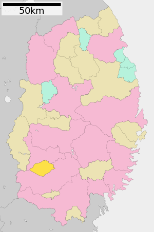
| Location Kanegasakis in Iwate Prefecture | ||
Kanegasaki ( Japanese 金 ケ 崎 町 , - chō ) is a city in Isawa County in Iwate Prefecture on Honshū , the main island of Japan . On October 1, 2018, 15,483 inhabitants lived in an area of 179.76 km². The 249 km long Kitakami flows through Takizawa .
Kanegasaki has been a twin town to the Thuringian city of Leinefelde-Worbis since 2001 .
Sons and daughters
- Hōko Kuwashima (* 1975), voice actress ( Seiyū )
See also
Web links
Commons : Kanegasaki, Iwate - collection of pictures, videos and audio files


