Kinkaid Township
| Kinkaid Township | ||
|---|---|---|
|
Location in Illinois
|
||
| Basic data | ||
| Foundation : | 1884 | |
| State : | United States | |
| State : | Illinois | |
| County : | Jackson County | |
| Coordinates : | 37 ° 49 ′ N , 89 ° 33 ′ W | |
| Time zone : | Central ( UTC − 6 / −5 ) | |
| Residents : | 486 (as of 2010) | |
| Population density : | 5.3 inhabitants per km 2 | |
| Area : | 94.03 km 2 (approx. 36 mi 2 ) of which 92.28 km 2 (approx. 36 mi 2 ) is land |
|
| Height : | 175 m | |
| Postcodes : | 62280, 62907, 62950 | |
| Area code : | +1 618 | |
| FIPS : | 17-40104 | |
| GNIS ID : | 429211 | |
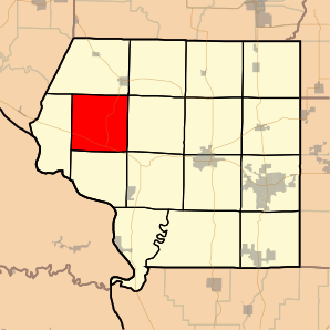
 Location of Kinkaid Township in Jackson County |
||
The Kinkaid Township is one of 16 townships in Jackson County in the southwest of the US -amerikanischen state of Illinois . In 2010 the Kinkaid Township had 486 residents.
geography
The Kinkaid Township is about 3 kilometers east of the Mississippi , which forms the border with Missouri . The mouth of the Ohio at the intersection of the states of Illinois, Missouri and Kentucky is around 120 km south.
The Kinkaid Township is located at 37 ° 49 ' N , 89 ° 33' W and extends over 94.03 km², which is spread over 92.28 km² of land and 1.75 km² of water.
The township is located in the north-west of Jackson County and borders on Bradley Township in the north, Ora Township in the northeast, Levan Township in the east, Sand Ridge Township in the southeast, Fountain Bluff Township in the south and Fountain Bluff Township in the west the Degognia Township .
traffic
To the southwest of the Township here the Illinois portion extending along the Mississippi Great River Road forming Illinois State Route 3 . Illinois State Route 151 branches off from this at its southern endpoint . All other roads are county roads or further subordinate and partly unpaved roads.
Parallel to Illinois State Route 3, a Union Pacific Railroad line runs through the far southwest corner of the township.
The Southern Illinois Airport is located around 30 km east of the Kinkaid Township, a regional airport. The nearest major airport is Lambert-Saint Louis International Airport (around 160 km northwest).
Demographic data
According to the 2010 census , there were 486 people in 191 households in Kinkaid Township. The population density was 5.3 people per square kilometer. Statistically, 2.54 people lived in each of the 191 households.
The racial the population was composed of 99.2 percent white, 0.2 percent (one person) Asian and 0.2 percent from other ethnic groups; 0.4 percent were descended from two or more races. Hispanic or Latino of any race was 1.6 percent of the population.
22.6 percent of the population were under 18 years old, 61.4 percent were between 18 and 64 and 16.0 percent were 65 years or older. 50.4 percent of the population was female.
The average annual income for a household was 52,083 USD . The per capita income was $ 20,292. 8.5 percent of the population lived below the poverty line.
Localities
In addition to scattered settlements, the following ( unincorporated ) settlements exist in Kinkaid Township :
Individual evidence
- ^ A b American Fact Finder. Retrieved August 9, 2012
- ↑ Distance information according to Google Maps. Accessed on August 9, 2012
