
Grächen
| Grächen | |
|---|---|
 |
|
| State : |
|
| Canton : |
|
| District : | Visp |
| BFS no. : | 6285 |
| Postal code : | 3925 |
| Coordinates : | 631 137 / 116251 |
| Height : | 1619 m above sea level M. |
| Height range : | 795–3057 m above sea level M. |
| Area : | 14.27 km² |
| Residents: | 1251 (December 31, 2018) |
| Population density : | 88 inhabitants per km² |
| Website: | www.gemeinde-graechen.ch |
 Grächen VS |
|
| Location of the municipality | |
  |
|
Grächen ( Valais German : Greechu ) is a municipality and a civic community of the district Visp and a parish of the deanery Visp in the Swiss canton of Valais . It is located in the Mattertal.
geography
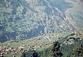
Grächen is 1619 m above sea level. M. on a terrace above the neighboring village of St. Niklaus . To the south, Grächen borders Gasenried in the municipality of St. Niklaus . The Kipfen / Chipfe settlement between the main road Stalden - Täsch and the Mattervispa belongs to Grächen . Grächen is located in the area with the least rainfall in Switzerland and the Alps.
Climate table
| Grächen, 1981-2010 | ||||||||||||||||||||||||||||||||||||||||||||||||
|---|---|---|---|---|---|---|---|---|---|---|---|---|---|---|---|---|---|---|---|---|---|---|---|---|---|---|---|---|---|---|---|---|---|---|---|---|---|---|---|---|---|---|---|---|---|---|---|---|
| Climate diagram | ||||||||||||||||||||||||||||||||||||||||||||||||
| ||||||||||||||||||||||||||||||||||||||||||||||||
|
Average monthly temperatures and precipitation for Grächen, 1981–2010
Source:
|
||||||||||||||||||||||||||||||||||||||||||||||||||||||||||||||||||||||||||||||||||||||||||||||||||||||||||||||||||||||||||||||||||||||||||||||||||||||
The heat record in Grächen was set on June 27, 2019 at 30.8 ° C.
history

The place was first mentioned in 1295 as de Grangiis and 1307 as Grenekun . In 1433 a separate chapel was built in honor of St. James, which was expanded into a church in 1704. In 1750, Grächen was completely separated from the parish of Stalden . The present church was built in 1935.
For centuries, the water from the Ried glacier or the Riedbach of the municipality of St. Niklaus has been used for irrigation by four carts or water pipes , as the suonen in the Mattertal are called, onto the meadows and, earlier, onto the fields. The oldest and longest water channel in Grächen is called Eggeri . It directs the glacier water to Bärgji up to the Hannigalp. Some of the water pipes are still used to irrigate the meadows today. Until a few decades ago, grain, especially rye, was grown in Grächen.
population
| Population development | ||||||||
|---|---|---|---|---|---|---|---|---|
| year | 1850 | 1900 | 1950 | 2000 | 2010 | 2012 | 2014 | 2016 |
| Residents | 338 | 389 | 665 | 1254 | 1400 | 1408 | 1382 | 1313 |
administration
The executive branch is represented by the local council, which consists of five members. Legislative period 2017–2020: Christof Biner mayor, Kurt Ruppen vice-president, and the councilors Liliane Brigger, Stefan Jeiziner and Serge Pollinger.
economy
traffic
Since 1953 Grächen has been connected to St. Niklaus by a cantonal road . In contrast to Zermatt , Bettmeralp and Saas-Fee, Grächen is not completely car-free. Niedergrächen and a northern part of the village can be reached by car. Most of Grächen, including the village center, is car-free and only electric cars can drive on. A large parking garage is available. Grächen is easily accessible by public transport. From Brig or Visp the Matterhorn-Gotthard-Bahn travels to St. Niklaus . The post bus takes travelers to the change until after Grächen. On weekends there are additional direct connections from Visp. All connections are ordered by the Matterhorn-Gotthard-Bahn and operated by PostBus Switzerland.
Grächen is a particularly popular place for families for summer and winter holidays. In 2003, around 400,000 overnight stays (60% in winter, 40% in summer) were registered in hotels, chalets and holiday apartments.
Summer tourism
Easy, mostly flat hiking trails lead along the four «Wasserleite» ( Suonen ) Bineri , Drieri , Chilcheri and Eggeri . The Hannigalp cable car station ( 2114 m ) is the starting point for hikes across the Alps and mountain forests . Grächen is the starting point of the Balfrin high-altitude trail to Saas-Fee (approx. 7 hours) and the destination of the Europe trail from Zermatt via Gasenried . The hike takes 12 hours. That is why many hikers spend the night halfway in the Europahütte . The two high-altitude trails have been signposted by Wanderland Schweiz as regional route 27 “Swiss Tour Monte Rosa” Saas-Fee – Zermatt since 2008 . On the three-day tour, Grächen serves as an overnight place.
The Balfrin high-altitude trail from Grächen to Saas-Fee is also the 16th stage of the Saas-Fee - Grächen Alpine Pass Trail. Its 17th stage continues via St. Niklaus Dorf , Jungs and the Augstbord Pass to Gruben.
Also open to mountain efficient family is the Bordierhütte the SAC , which Gasenried can be achieved.
Winter tourism
In winter, mainly alpine skiing is practiced in Grächen. The Grächer winter sports area extends from Grächen at 1619 m up to the Seetalhorn at 2864 m . With a total of ten lifts (one gondola, three chair lifts and six ski lifts), 40 km of slopes with guaranteed snow are accessible.
The winter sports area is particularly popular with families. The crèche in the middle of the ski area is free for ski pass holders. Parents can leave their children in the care of carers for two hours.
In addition to ski schools, practice lifts and slopes are also available. In the SiSu family park there are magic carpets and practice lifts for those first attempts at skiing. There is also a large playground, a cinema igloo and the snow-tube track.
A fairy tale gondola was inaugurated in winter 2011/2012. In ten of the 55 gondolas, Silvia Jost tells the fairy tales of the Brothers Grimm. From the outside it can be seen which fairy tale can be heard while driving.
In the 2017/2018 winter season, a new 4- seater chairlift was put into operation, which brings guests from the Plattja back to the Seetalhorn. It replaces the old 2-seater chairlift on which the concession had expired. In addition, the slope was extended.
Museums
The local museum is located in the former old parish hall of Grächen. Is shown u. a. the life and work of the most famous Graechner Thomas Platter .
On Thomas-Platter-Weg there is a museum for woodworking tools from all over the world in a beautiful old Spycher .
A visit to the mountain guide museum in St. Niklaus Dorf is worthwhile.
Personalities
- Thomas Platter the Elder (1499–1582), humanistic scholar and autobiographical writer
- Adolf Fux (1901–1973), journalist, writer and politician, Grand Councilor (1933–1937, 1949–1961)
- Ernst Schnydrig (1912–1978), religious priest, journalist and writer
- Father Erich Williner (1933), missionary in Cochabamba, Bolivia
literature
- Rachel Siggen-Bruttin: Grächen. In: Historical Lexicon of Switzerland . 2007 .
- Bernard Truffer: Kipfen. In: Historical Lexicon of Switzerland . 2006 .
gallery
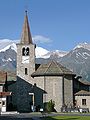
Church of Grächen

View from Moosalp to Grächen, on the right the Ried glacier with the snow-covered four-thousand-meter peaks of the Mischabel needle ridge

The sports center in Grächen, where the 113th Swiss Individual Chess Championships took place in 2013.

View of the Matterhorn


Series of pictures 1959

Niedergrächen with grain fields

To Niedergrächen

Meadows above Grächen
Area north of the church; the church can be seen on the left at the edge of the picture

The church and laundry to dry

Postbus arrival at Hotel Walliserhof

Egga Chapel


Web links
- Grächen on the ETHorama platform
- Official website of the municipality of Grächen
- Official WebGIS of the municipality of Grächen
- Private weather station in Grächen
- Grächen tourism
Individual evidence
- ↑ Permanent and non-permanent resident population by year, canton, district, municipality, population type and gender (permanent resident population). In: bfs. admin.ch . Federal Statistical Office (FSO), August 31, 2019, accessed on December 22, 2019 .
- ↑ The dialect name Chipfe is on the map of Switzerland used
- ↑ Climate table. In: meteoschweiz.admin.ch. meteoschweiz, accessed on December 12, 2018 .
- ↑ Maximum temperatures - New heat records in both the north and the south. In: srf.ch . June 27, 2019, accessed June 27, 2019 .
- ↑ Official course book: 12.552 , 2015/16, accessed on November 4, 2015
- ↑ Hiking in Switzerland : Swiss Tour Monte Rosa , accessed on November 4, 2015
- ↑ Grächen Bergbahnen-Informations , accessed on February 4, 2011
- ↑ 113th Swiss Individual Chess Championships, 2013 in Grächen
Baltschieder | Eisten | Embd | Grächen | Lalden | Randa | Saas-Almagell | Saas-Balen | Saas-Fee | Saas-Grund | St. Niklaus | Stalden | Staldenried | Täsch | Törbel | Visp | Visperterminen | Zeneggen | Zermatt
Former communities: Eyholz | Gasenried | St. Niklaus Dorf | St. Niklaus Matt
Canton of Valais | Districts of the canton of Valais | Municipalities of the canton of Valais