
Lübeck-St. Lorenz
St. Lorenz is a district of Lübeck west of the Holsten Gate and northwest of the city center, which politically and legally includes the districts of Sankt Lorenz Nord (north of the railway) and Sankt Lorenz Süd (south of the railway on the left bank of the Trave and Stadtgraben outside the ramparts). As with the other two historic districts of St. Jürgen and St. Gertrud, the suburban church St. Lorenz on Steinrader Weg, which dates back to the chapel of a plague cemetery from the 16th century, is named after it. The district includes the districts of St. Lorenz Nord Groß-Steinrade / Schönböcken (23), Dornbreite (24), Holstentor Nord (04) and Falkenfeld / Vorwerk (05). St. Lorenz Süd (03) is not divided into city districts.
| cards | |
|---|---|

|

|
| Basic data St. Lorenz North | |
| Area : | 27.9 km² |
| Residents : | 41 915 (2007) |
| Population density : | 1502 inhabitants per km² |
| Basic data St. Lorenz Süd | |
| Surface: | 2.9 km² |
| Residents : | 15 014 (2007) |
| Population density : | 5227 inhabitants per km² |
location
Because of its location in the west of Lübeck in front of the Holstentor, towards Holstein , the area was also called Holstenfeld before the intensive development in the course of Lübeck's industrialization at the end of the 19th century .
The Teerhofinsel originally belonged to St. Gertrud and only came to St. Lorenz in 1884 after the Travedurchstich.
history

The acquisition of the outer areas to the west of the old town took place later than those to the east. Initially, the western bank of the Trave was the border with Holstein. It was only with the Lübeck Imperial Freedom Letter of 1226 that the narrow strip up to the streams of Paddelügge and Krempelsdorf was added to the urban area. Vorwerk was acquired around 1250. With this land acquisition west of the city, a tendency became clear that continued through the next centuries. In 1255 the people of Lübeck fought against the robber barons of Buchwaldt from Holstein with military means , but actually they preferred to “buy out” these families, not only for the safety of the young city, but also for investments in times of this rapid rise to the trading power of the Baltic Sea region. In the fight against these robber barons, peace alliances were concluded with the Counts of Holstein several times.
For centuries, the area in front of the Holsten Gate, the Holstenfeld, was essentially used as a common pasture, also known as "Stadt Freiheit", for the cattle kept in the old town, which were herded to pasture here during the day. In addition, two roads led from the Holstentor into the Holstein region, the Lübsche Trade to Segeberg and on to the North Sea , the other to Plön . The flat, loamy land contained a few moist hollows that had been dug to become fish ponds. The street names in St. Lorenz Süd such as "Am Retteich" or "Karpfenstraße" still bear witness to this today.
With the relocation of the main train station from the Holstentor to the current location, the Holstenfeld was cut up by the new, direct Hamburg railway line into the current districts of St. Lorenz North and South. A second cut was made in the 1930s with the construction of the A1 Hamburg - Lübeck. These two modern traffic axes and their connections to the city and the port have influenced and shaped the appearance and development of the city districts since their formation.
During the Second World War, the St. Lorenz Nord district was also hit by the air raid on Lübeck on Palm Sunday night in 1942. The Warendorpstrasse bunker is one of three preserved high bunkers that have been preserved as typical aerial warfare architecture in the district.
History of individual city districts
Mandrel width
Scheduled settlement from 1921; official name from 1939 ( Dornbreite settlement ) part of the former Krempelsdorf estate district.
Falkenfeld
Name of the corridor already in 1669; official name from 1940 ( Falkenfeld settlement )
The settlement house (Butterstieg 12), the Protestant St. Markus Church (Am Dreworp 43) and the Falkenfeld primary school (Helgolandstrasse 5) are located in Falkenfeld.
Big stone wheel
The district was not incorporated into Lübeck until 1970 as part of a regional reform ; previously he belonged to Stockelsdorf .
Groß Steinrade is a former Lübsches estate. The first owner named in 1306 was Marquard von Sandberg , who sold Groß Steinrade and Eckhorst to Dietrich von Ahlen , a citizen of Lübeck . Later there were frequent changes of ownership (v. Wickede, v. Calven, v. Brömbsen, etc.) until the estate came to Henning von Rumohr in 1732 . This family remained in possession of the estate until the death of the last Rumohr, General Detlev von Rumohr († 1961). The house and yard have meanwhile been torn down; the approximately 150 hectare forest property is given to the federal government and is used as a desert area military training area from 1965 onwards.
Krempelsdorf

On April 1, 1913, incorporated into Lübeck.
Former lübsches estate. The Perseval family is mentioned as the first owner in 1399 ; later frequent changes of ownership ( Kerckring, v. Lüneburg, v. Albedyll, Blohm, v. Rumohr, Souchay ). Listed in the Lübeck combing book (1316–1338) as crempelstorpe with 18 houses. From the end of the 1920s owned by Lübeck. The manor house, built by Christian von Brockes in 1786, has been leased to the Paul Gerhardt congregation since 1932 and serves as a parish hall.
Schönbuck
On September 24, 1921, incorporated into Lübeck.
Main article: Lübeck Schönböcken
Former lübsches estate. The Lübeck councilman Gerhard von Bremen is named as the first owner in 1271 ; later frequent changes of ownership ( v. Warendorp, v.Ahlen, v.Stiten, v.Mokerke etc. ). In the Lübeck combing book (1316–1338) listed as a sconeboke with 9 houses. Well dissolved and owned by the City of Lübeck from 1926. The mansion was used as a retirement home until 2007. ( At an angle )
Vorwerk

In the Lübeck combing book (1316–1338) listed as a droghevorwerk with 20 houses. Incorporated into Lübeck on April 1, 1913; Scheduled settlement from 1921.
The Vorwerker Friedhof is the largest in Lübeck with 53 hectares and was opened in 1907. It was designed by Erwin Barth as a park with avenues, hedges, forest and seating areas. It has memorials and war cemeteries as a special feature.
District redevelopment
While the area between the main train station and the Holstentor is now developing independently as an expansion area and access to the old town island , albeit with decades of delay, and is also attractive as a residential area in its side streets close to the city, exist in the north-western part of St. Lorenz-Süd There are certainly problems and areas of tension along the railway line. St. Lorenz-Süd is therefore included in the Social City funding program and has an active neighborhood management system .
In addition, the city of Lübeck was able to keep the Drägerwerk site in the district. To do this, a public road had to be sold to the Drägerwerk that cut across the factory premises. This led to a reorganization of the traffic flows and traffic axes in St. Lorenz-Süd, which was only completed after the expansion and electrification of the Hamburg-Lübeck railway line in 2008 and which made it necessary to demolish and build new road bridges over the railway line.
Plans are in place to build a pedestrian bridge over the city moat on a new access axis from the main station through the linden arcades to the music and congress hall and the Becker pit in Lübeck's old town.
Buildings
port
The port of Lübeck is a generic term for all port facilities that are located on the lower reaches of the Trave from Lübeck's old town to Travemünde . While the economic importance of the ports located in the old town has continuously decreased, the Vorwerker Hafen with the Nordlandkai in the St. Lorenz-Nord district is one of the pulsating heart of the Lübeck port, which was connected in 2007 with the completion of the bridge over the Trave the expansion of the north bypass will improve. The Vorwerker Hafen is operated by the Lübeck port company. According to the plans of the port company, it is to be expanded by the area on the Teerhof Island . To do this, it is necessary to fill the old arm of the Trave in between.
Fire and Police Station

The establishment of its own fire and police station made the steady growth of the suburb necessary . Their building ensemble was put into operation in 1902. The relocation of the Lübeck main station, its marshalling yard and freight yard to the suburbs, the Drägerwerk, the barracks of the fusiliers of the 2nd Hanseatic and from 1897 the 2nd battalion of the Lübeck 3rd Hanseatic Infantry Regiment No. 162 as well as the establishment of a substation of the municipal power station for their supply increased the importance of the district. While the fire station is out of order today, the "Feuerwerk" restaurant is located in the former vehicle hall, the police station is still in operation today. Compared to 1902, however, it takes up considerably more space. As a result, the former “main” entrance is no longer used as such.
Central Station

The Lübeck main station (architect Fritz Klingholz ) is, together with the ZOB, the central traffic junction of the public transport operated by Lübeck city traffic in the Hanseatic city. The extensive renovation was completed in 2007. In terms of urban planning, the relocation of the main train station from the Holstentor to its current location at the beginning of the 20th century caused a problem because it meant that the gap in the connection between the train station and the old town as the center could not be closed for 100 years, unlike in other cities. This is partly due to the intervening waterways of the Stadtgraben ( Puppenbrücke ), the Lübeck ramparts of the city fortifications, which are particularly extensive in the area of the Holsten Gate, and the further course of the Trave in front of the old town.
Lohmühle Stadium
The Lübeck stadium Lohmühle is the home of VfB Lübeck , at whose home games the district between the main station and the stadium directly at the Lübeck-Mitte exit of the A1, the colors green and white clearly dominate. It holds 17,869 people and has 5,048 seats and 11,250 standing places. 4,268 seats are covered. In addition, the stadium has 22 boxes with a total of 220 seats.
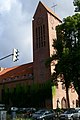
St. Lorenz Church
The St. Lorenz Church had existed since 1661. The population, which increased enormously from the end of the 19th century, forced a new building. One of the driving forces behind the construction of the new church in the same place was Johannes Bernhard . The main pastor inaugurated the new church on May 6, 1900. The construction of the new church in the district was primarily thanks to the investment of time , money and influence of Senator Friedrich Heinrich Bertling .
Luther Church
The Luther Church on Moislinger Allee was the place where one of Lübeck's martyrs worked and is now a memorial.
Linden arcades
The Lindenarcaden are a new service center between the train station and Lindenplatz with retail stores such as Saturn, banks, insurance companies and a sports and wellness center.
Bellevue castle
For the Lübeck merchant Hieronymus Küsel, the city architect Johann Adam Soherr built the Bellevue palace on Einsiedelstrasse from 1754 to 1756 in the Rococo style , which was surrounded by an elaborately designed garden. An avenue led to the Trave. The house with two gatehouses is owned by the family of a Lübeck merchant.
Salmon weir
On behalf of the Lübeck citizenship, city architect Johann Adam Soherr built the Lachswehr garden restaurant on the Alte Trave , a dead arm of the river, in 1771 . There was already a jug here in the 15th century.
German Pension Insurance North
The German pension insurance North is headquartered in a star-shaped building with green area and water basins in a cul the brick street opposite the swimming pool St. Lawrence. The building was planned and built by the architect Günter Behnisch .

Linden arcades, completed in 2003

Bellevue castle, built between 1754 and 1756
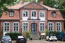
The Lachswehr restaurant from 1771

Headquarters of the German Pension Insurance North


Further
Monuments
Near the main train station on the footpath to the Lindenplatz roundabout, the monuments to Kaiser Wilhelm I by Louis Tuaillon (1862–1919) and Chancellor Otto von Bismarck by Emil Hundrieser (1846–1911) face each other in a small park . The people of Krempelsdorf erected a memorial in the Herrengarten for those who fell in their community in the First World War .

Kaiser Wilhelm I (1917)

Otto von Bismarck (1903)

Fallen monument in Krempelsdorf

Dornwidth Monument to the 1932 measure


Cultural monuments
schools
Student numbers from the school year 2019/2020.
-
Funding Centers (FöZ)
- Wilhelmshöhe School, (FöZ Geistige Entwicklung), Schwartauer Allee (opened in 1909, ex 6th St. Lorenz School), 99 students in 11 classes, 72 supervised
- Anton Schilling School, Pestalozzi School branch, Fackenburger Allee , approx. 120
- Paul Burwick School, sponsored by Vorwerker Diakonie, (FöZ Geistigeentwicklung), Triftstraße, 70 students in 10 classes
- Primary schools (GS)

- Luther School, Moislinger Allee (opened in 1901, formerly the 5th double elementary school St. Lorenz), 229 students in 11 classes
- Mühlenweg School, Moislinger Mühlenweg, 187 students in 8 classes
- School on Koggenweg, Koggenweg, 246 students in 12 classes
- Pestalozzi School, Fackenburger Allee and branch in Dornbreite, (opened in 1900, ex 4th St. Lorenz Girls School, name since 1934), 308 students in 15 classes
- Paul-Gerhardt-Schule, Paul-Gerhardt-Straße (opened 1973), 221 students in 11 classes
- GS Groß Steinrade, Drögeneck (1695, in the current school building since 1910), 91 students in 4 classes
- GS Schönböcken, Schönböckener Hauptstraße (mentioned before 1700, regular lessons from 1867), 103 students in 4 classes
- GS Falkenfeld, Helgolandstrasse (opened 1951), 129 students in 8 classes
- Bugenhagen School, Moislinger Allee (opened in 1885, ex 2nd St. Lorenz School, name since 1934), 169 students in 8 classes
- Johannes-Prassek-Schule, Catholic primary school sponsored by the Bernostiftung , Moislinger Allee (opened 2011), 117 students in 8 classes
- Primary and Community Schools (GGemS), Community Schools (GemS)

- Baltic School, (GGemS with upper secondary school), Karavellenstraße, 1046 students in 47 classes
- Heinrich-Mann-Schule, (GGemS), Brüder-Grimm-Weg, 472 students in 26 classes
- Julius-Leber-Schule , (GGemS), created through the merger of Brockes-Schule and Bernt-Notke-Schule (2009), locations see p. there, 523 students in 30 classes
- Gotthard-Kühl-Schule, (GGemS), Lortzingstraße (new building opened in 1962, predecessor opened in 1869, ex 1st St. Lorenz School, name since 1934), 667 students in 33 classes
- School Tremser Teich, (GGemS), Am Behnckenhof (opened in 1966, ex 13th elementary school, ex elementary and secondary school Vorwerk), 670 students in 29 classes
- Holstentor Community School, (GemS), Wendische Strasse (opened in 1951, ex St. Lorenz Middle School, ex Holstentor Realschule, ex Holstentor Regional School), 522 students in 24 classes
- Free village school (GemS with upper level sponsored by Helauria eV Lübeck), Morierstraße, 20 students in 1 class
-
high school
- Carl-Jacob-Burckhardt-Gymnasium (UNESCO project school), Ziegelstraße (opened in 1957), 778 students in 33 classes
- former schools
- Bernt-Notke-Schule, Marquardplatz (opened in 1904, ex St. Lorenz Girls' Middle School, name since 1934)
- Brockes School, Brockesstraße (opened in 1909, ex 3rd St. Lorenz School, name since 1934)
Churches

-
Evangelical Lutheran
- St. Lorenz Church , Steinrader Weg ( first church consecrated in 1669, new building in 1900)
- St. Matthäi Church , Schwartauer Allee (foundation stone laid in 1899)
- Paul Gerhardt Church, on the outskirts (consecrated 1960)
- St. Markus Church, Beim Drögenvorwerk (foundation stone laid in 1952, construction started in 1957, parish hall 1961)
- Friedrich-von-Bodelschwingh-Kirche Beethovenstraße (laying of the foundation stone in 1963, consecrated in 1965)
- Luther Church , Moislinger Allee, (first inauguration 1914, bell tower 1923, parish hall 1927)
-
former churches
- St. Lazarus , Paul-Gerhardt-Straße (foundation stone laid in 1966, demolition decided, deedication at the end of 2007, rededicated in 2009)
- Melanchthon Church, Karpfenstrasse (laying of the foundation stone in 1960, church in 1965, demolished in May 2007, demolition November 2010)
-
Roman Catholic
- St. Bonifatius Church , Wickedestrasse (consecrated 1952)
- St. Birgitta, Narzissenweg (foundation stone laid in 1961)
-
Other denominations
- Friedenskirche, Evangelical Free Church Congregation, Ziegelstrasse
- Agape, Free Christian Community Lübeck, Artlenburger Strasse
- Kingdom Hall of Jehovah's Witnesses, Schwartauer Allee
- Fatih Mosque, Katharinenstrasse

St. Lorenz
Luther Church


Personalities

Lübeck's honorary citizen Willy Brandt , the first social democratic federal chancellor after the Second World War and winner of the Nobel Peace Prize in 1971, was born in Meierstrasse in St. Lorenz and grew up on Trappenstrasse. He attended the St. Lorenz Boys' Middle School and, from 1927, the Von Großheimsche Realschule in St. Lorenz, before moving to the Johanneum in Lübeck in 1928 .
Many other well-known members of Lübeck's social democracy also have their roots in this district.
With Elisabeth Haseloff , who took over a pastorate in the St. Matthäi congregation in 1958, Lübeck had the first female pastor in Germany.
See also
literature
- Lübeck Heimathefte, Heft 8/9, Holstenfeld-Hamberge , published by Charles Coleman in Lübeck, 1929.
- Lübeck home books. Issue 10/11, Krempelsdorf-Zarpen , published by Charles Coleman in Lübeck, 1930.
- Elke P. Brandenburg: St. Lorenz . (Small booklets on city history, edited by the archive of the Hanseatic city of Lübeck , No. 17) Lübeck 2001. ISBN 3-7950-3116-8 .
Web links
Individual evidence
- ^ Hubertus Neuschäffer: Manor houses and mansions in and around Lübeck , Wachholtz-Verlag, 1988, ISBN 3-529-02691-3
- ↑ Schleswig-Holstein Chamber of Agriculture (ed.): Garden routes between the seas. Route 5: Lübeck. 2nd revised edition, Kiel, May 2010
- ↑ 1914–1918 died for us […] Krempelsdorf community
- ↑ In 1932, when there was no work for 20,000 pairs of hands in Lübeck, the Reich gave 450,000.00 RM building loans for 165 settler positions and 600 allotment gardens
- ↑ Statistical Office for Hamburg and Schleswig-Holstein: Directory of general education schools in Schleswig-Holstein 2019/2020
- ↑ http://www.anton-schilling-schule-luebeck.de/Geschichte/geschichte.htm
- ^ Minutes of the church council meeting on June 12, 2007

Coordinates: 53 ° 52 ' N , 10 ° 40' E