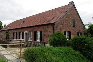
Kovermühle
| Kovermühle
|
||
|---|---|---|
|
The Kovermühle in Wachtendonk |
||
| Location and history | ||
|
|
||
| Coordinates | 51 ° 21 '36 " N , 6 ° 17' 32" E | |
| Location |
Germany
|
|
| Waters | Nice | |
| Built | 1349 first documented mention | |
| Shut down | 1945 End of milling activity | |
| technology | ||
| use | Flour mill | |
| Grinder | 1 grind | |
| drive | Watermill | |
| water wheel | undershot | |
The Kovermühle was at the Nice Situated water mill with an undershot water wheel in the town of Wachtendonk .
geography
The Kovermühle is located at Nette, Müllemer Straße 11, in the Wachtendonk district of Kleve in North Rhine-Westphalia . The Nice has a height of about 37 m above sea level . The care and maintenance of the water is the responsibility of the Netteverband, which is based in Nettetal .
history
The Kovermühle was owned by Schaesberg and was first mentioned in a document in 1349. It and the Nettmühle below are likely to have given the name to the old farmers' community "Müllem" and the Müllemer Hof, which was mentioned in the 14th century. The mill was operated exclusively as a grain mill with an undershot water wheel. Mill operations were stopped at the end of 1945. The water accumulation and the water wheel were dismantled. After an agricultural use, the restored miller's house is now used as a residential building.
gallery
literature
- Hans Vogt: Lower Rhine water mill guide. 2nd Edition. Niederrhein Association, Krefeld 1998, ISBN 3-00-002906-0 , pp. 470–473.


