Pletzmühle
| Pletzmühle
|
||
|---|---|---|
|
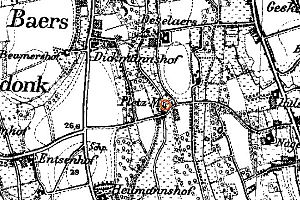
Pletzmühle on the new record in 1892 |
||
| Location and history | ||
|
|
||
| Coordinates | 51 ° 29 '27 " N , 6 ° 19' 33" E | |
| Location | Germany | |
| Waters | Gelderner Fleuth | |
| Built | before 1403 | |
| Shut down | 1930 | |
| technology | ||
| use | Oil , pearl barley and grain mill | |
| Grinder | 1 grinding cycle 1 oil press alternately | |
| drive | Watermill | |
| water wheel | undershot | |

The Pletzmühle was a water mill located on the Geldern Fleuth in the city of Geldern with an undershot water wheel .
geography
The Pletzmühle was located on the Gelderner Fleuth, Möhlendyck / In de Middag, in the Baersdonk district, in the city of Geldern, Kleve district , in North Rhine-Westphalia .
The Geldern Fleuth has a height of approx. 23 m above sea level . The care and maintenance of the water is the responsibility of the Niersverband , which is based in Viersen .
history
The Pletz mill belonged to Hof ter Moilen , a money skills fief that was mentioned 1403rd In 1423 a Sander ter Molen was named on a list of feudal people who were called up to defend the city of Geldern after the death of Duke Reinald IV , as a war of succession was feared. In 1824 Peter Nilkens is the owner , who in 1847 receives permission to set up a barley and oil corridor on his grain mill , in addition to the previous fruit grinding, so that the various plants can only be operated alternately. Milling was stopped around 1930.
literature
- Hans Vogt: Lower Rhine water mill guide. 2nd Edition. Niederrhein Association, Krefeld 1998, ISBN 3-00-002906-0 .
- Susanne Sommer: Mills on the Lower Rhine . Rheinland Verlag, Cologne 1991, ISBN 3-7927-1113-3 .

