
Kapellener Mill
| Kapellener Mill
|
||
|---|---|---|
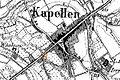
 Location on the original cadastral map from 1846 |
||
| Location and history | ||
|
||
| Coordinates | 51 ° 34 '11 " N , 6 ° 21' 38" E | |
| Location | Germany | |
| Waters | Issumer Fleuth | |
| Built | before 1326 | |
| Shut down | 1925 | |
| technology | ||
| use | Fruit grinder | |
| Grinder | 1 grind | |
| drive | Watermill | |
| water wheel | undershot | |

The Kapellener Mühle was a watermill located on the Issumer Fleuth in the city of Geldern with an undershot water wheel .
geography
The Kapellener Mühle was located on the Issumer Fleuth, Am Mühlenwasser, in the Kapellen an der Fleuth district , in the city of Geldern, Kleve district , in North Rhine-Westphalia .
The Issumer Fleuth has a height of approx. 24 m above sea level here . The care and maintenance of the water is the responsibility of the Niersverband , which is based in Viersen .
history
The Kapellener Mühle was first mentioned in 1326 in the Geldrian fiefdom register as a fiefdom of Loef van Berenbroek. It was a border mill between Geldern and Kleve . In 1442 the border ran at the mill of Claiss (Claes), the owner of the Wankum house near Kapellen. In 1823 Baroness von Nagel Dornik was mentioned as the owner and Gerhard Josef Polders as the tenant . In 1836 the fruit mill was called Kapellensche Mühle . In 1880 the mill was owned by Arnold Polders. The regulation of the Fleuth in 1925 also brought about the closure of the mill.
gallery
Kapellener Mühle on the new record in 1892

Kapellener Mühle on the Tranchot map 1802


literature
- Hans Vogt: Lower Rhine water mill guide. 2nd Edition. Niederrhein Association, Krefeld 1998, ISBN 3-00-002906-0 .
- Susanne Sommer: Mills on the Lower Rhine . Rheinland Verlag, Cologne 1991, ISBN 3-7927-1113-3 .
Web links
Individual evidence
On the Niers :
old oil mill Geldern |
Old Wylick Mill |
Aspermühle |
Bimmen mill |
Castle mill Geldern |
Höster mill |
Holtheyder Oil Mill |
Goch grain mill |
Corn mill house Caen |
Corn mill Wachtendonk |
Lohmühle Goch |
Lohmühle Wachtendonk |
Mill on the Fleuth |
Mills from Haus Gesselen |
Neumühle |
Niersmühle Weeze |
Oil mill Goch |
Oil mill house Caen |
Wachtendonk oil mill |
Oil mill knowledge |
Ponter Mill |
Sawmill knowledge |
Castle mill knowledge |
Schravelsche Mühle |
Susmühle |
Vlassrather grain and oil mill |
Viller Mill |
Fulling Mill Goch |
Fulling Mill House Caen |
Fulling Mill Knowledge |
Fulling mill and oil mill Geldern |
Willick's Mill |
Windvonderer Mühle
An der Nette :
Kovermühle |
Nettmühle |
Vorster Mühle
Am Leitgraben / Mühlengraben :
Vennmühle Straelen |
Paesmühle |
Maesemühle
An der Gelderner Fleuth :
Pletzmühle |
Wyemühle
An der Issumer Fleuth :
Langendonker Mühle |
Kapellener Mill |
Honselaerer Mühle
At the Kervenheimer Mühlenfleuth :
Fallmühle |
Kervenheimer Mühle
An der Kendel :
Yshövelsche Mühle |
Mill to garbage