
Kervenheimer Mill
| Kervenheimer Mill
|
||
|---|---|---|
 The Kervenheimer Burg in 2013 |
||
| Location and history | ||
|
||
| Coordinates | 51 ° 37 '54 " N , 6 ° 16' 42" E | |
| Location | Germany | |
| Waters | Kervenheimer Mühlenfleuth | |
| Built | before 1441 | |
| Shut down | 1889 | |
| technology | ||
| use | Flour mill | |
| Grinder | 1 grind | |
| drive | Watermill | |
| water wheel | undershot | |

The Kervenheimer Mühle was a watermill located on the Kervenheimer Mühlenfleuth in the town of Kevelaer with an undershot water wheel .
geography
The Kervenheimer Mühle was located on the Kervenheimer Mühlenfleuth, on Schlossstrasse, in the Kervenheim district , in the town of Kevelaer, Kleve district , in North Rhine-Westphalia .
The Kervenheimer Mühlenfleuth has a height of approx. 22 m above sea level . The care and maintenance of the water is the responsibility of the Niersverband , which is based in Viersen .
history
The mill was first mentioned in a feudal award in 1411. The mill was opposite the outer bailey and was fed with the water of the Fleuth. It worked as a ban mill that only ground grain . Oil fruits were processed in Kervenheim in Göpel or Ross oil mills . This also happened with grain on arid summer days.
The mill was also called the Flöth mill. Baron von Hertefeld zu Liebenberg near Berlin is named as the owner in 1848 . In 1888 the mill is bought by the Kervenheimer Mühlenfleuthgenossenschaft. When the mill coke was backfilled in 1889, the mill was also shut down.
gallery

Kervenheimer Mühlenfleuth
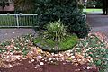
Millstone at the castle entrance

Pond waters at the castle

Kervenheimer Mühle on the new record in 1892

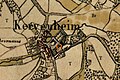
Kervenheimer Mühle on the original cadastral map 1843
Kervenheimer Mühle on the 1802 tranchot card


.jpg)
.jpg)
.jpg)
literature
- Hans Vogt: Lower Rhine water mill guide. 2nd Edition. Niederrhein Association, Krefeld 1998, ISBN 3-00-002906-0 .
- Susanne Sommer: Mills on the Lower Rhine . Rheinland Verlag, Cologne 1991, ISBN 3-7927-1113-3 .
Web links
Individual evidence
On the Niers :
old oil mill Geldern |
Old Wylick Mill |
Aspermühle |
Bimmen mill |
Castle mill Geldern |
Höster mill |
Holtheyder Oil Mill |
Goch grain mill |
Corn mill house Caen |
Corn mill Wachtendonk |
Lohmühle Goch |
Lohmühle Wachtendonk |
Mill on the Fleuth |
Mills from Haus Gesselen |
Neumühle |
Niersmühle Weeze |
Oil mill Goch |
Oil mill house Caen |
Wachtendonk oil mill |
Oil mill knowledge |
Ponter Mill |
Sawmill knowledge |
Castle mill knowledge |
Schravelsche Mühle |
Susmühle |
Vlassrather grain and oil mill |
Viller Mill |
Fulling Mill Goch |
Fulling Mill House Caen |
Fulling Mill Knowledge |
Fulling mill and oil mill Geldern |
Willick's Mill |
Windvonderer Mühle
An der Nette :
Kovermühle |
Nettmühle |
Vorster Mühle
Am Leitgraben / Mühlengraben :
Vennmühle Straelen |
Paesmühle |
Maesemühle
An der Gelderner Fleuth :
Pletzmühle |
Wyemühle
An der Issumer Fleuth :
Langendonker Mühle |
Kapellener Mill |
Honselaerer Mühle
At the Kervenheimer Mühlenfleuth :
Fallmühle |
Kervenheimer Mühle
An der Kendel :
Yshövelsche Mühle |
Mill to garbage