Fulling mill knowledge
| Fulling mill knowledge
|
||
|---|---|---|
|
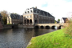
Castle Wissen in Weeze |
||
| Location and history | ||
|
|
||
| Coordinates | 51 ° 36 '54 " N , 6 ° 13' 19" E | |
| Location |
Germany
|
|
| Waters | Niers | |
| Built | 18th century | |
| Shut down | 19th century | |
| technology | ||
| use | Fulling Mill | |
| Grinder | Grinding mill | |
| drive | Watermill | |
| water wheel | undershot | |
The Walkmühle Wissen was a water mill located on the Niers in the municipality of Weeze with an undershot water wheel .
geography
The Walkmühle Wissen is located on the right side of the Niers, at Schloss Wissen, in the municipality of Weeze, Kleve district , in North Rhine-Westphalia . The Niers has a height of approx. 19 m above sea level here . The care and maintenance of the water is the responsibility of the Niersverband , which is based in Viersen .
history
Wissen Castle was first mentioned in 1316. Haus und Gut Wissen appear as the property of the Gocher bailiff Heinrich von der Straten in 1372 , when Count Adolf von Kleve issued a letter of protection for the parish of Weeze and the Haus zu Wissen. The first mill was mentioned in a document in 1437, when Johann von der Straten , son of Heinrich von der Straten , was given the mill as a fief by the wealthy Viktorstift in Xanten . In 1461 the von der Straten family sold the entire property to the von Loe family , who still own it today.
After 1437 a real mill economy developed next to the castle. So four mills were built directly on the Niers or on the moats (also known as graves ) of the castle. In addition to the Schlossmühle Wissen , the Ölmühle Wissen , the sawmill Wissen and the Fulling Mill Wissen. The water supply for the moat systems is regulated by a weir above the castle on the Niers.
The Walkmühle Wissen was the fourth mill in the association of the Wissen mills. It stood by a ditch, southwest of the castle, on the right side of the Niers. In 1805 the mill could still be found on the map of the Prussian Major General Karl Ludwig von Le Coq .
gallery
Fulling mill knowledge on the Tranchot card 1802/04
literature
- Hans Vogt: Lower Rhine water mill guide. 2nd Edition. Niederrhein Association, Krefeld 1998, ISBN 3-00-002906-0 . Pp. 559-561
- Susanne Sommer: Mills on the Lower Rhine . Rheinland Verlag, Cologne 1991, ISBN 3-7927-1113-3 . Pp. 183-184


