
Wyemühle
| Wyemühle
|
||
|---|---|---|
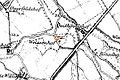
 Location on the original cadastral map 1843 |
||
| Location and history | ||
|
||
| Coordinates | 51 ° 32 '41 " N , 6 ° 18' 57" E | |
| Location | Germany | |
| Waters | Gelderner Fleuth | |
| Built | before 1326 | |
| Shut down | 17th century | |
| technology | ||
| use | Flour mill | |
| Grinder | 1 grind | |
| drive | Watermill | |
| water wheel | undershot | |

The Wyemühle was a watermill located on the Geldern Fleuth in the town of Kevelaer with an undershot water wheel .
geography
The Wyemühle was located on the Gelderner Fleuth, Am Mühlenwasser, in the district of Wetten , in the city of Kevelaer, Kleve district , in North Rhine-Westphalia .
The Geldern Fleuth has a height of approx. 24 m above sea level . The care and maintenance of the water is the responsibility of the Niersverband , which is based in Viersen .
history
The location of the Wyemühle was the Wyehof. He was money skills fief and probably with the Weysenhof on the Tranchotkarte identical. In 1326 the yard and mill belonged to a Henken van den Wy . In the 16th and 17th centuries the property was an after-fief from House Vlassrath . The last known fiefdom letter was issued to Count Hoensbroich in 1791 .
gallery
The Weysenhof was reopened in 1892

The Weysenhof on the Tranchot card 1802


literature
- Hans Vogt: Lower Rhine water mill guide. 2nd Edition. Niederrhein Association, Krefeld 1998, ISBN 3-00-002906-0 .
- Susanne Sommer: Mills on the Lower Rhine . Rheinland Verlag, Cologne 1991, ISBN 3-7927-1113-3 .
Web links
Individual evidence
On the Niers :
old oil mill Geldern |
Old Wylick Mill |
Aspermühle |
Bimmen mill |
Castle mill Geldern |
Höster mill |
Holtheyder Oil Mill |
Goch grain mill |
Corn mill house Caen |
Corn mill Wachtendonk |
Lohmühle Goch |
Lohmühle Wachtendonk |
Mill on the Fleuth |
Mills from Haus Gesselen |
Neumühle |
Niersmühle Weeze |
Oil mill Goch |
Oil mill house Caen |
Wachtendonk oil mill |
Oil mill knowledge |
Ponter Mill |
Sawmill knowledge |
Castle mill knowledge |
Schravelsche Mühle |
Susmühle |
Vlassrather grain and oil mill |
Viller Mill |
Fulling Mill Goch |
Fulling Mill House Caen |
Fulling Mill Knowledge |
Fulling mill and oil mill Geldern |
Willick's Mill |
Windvonderer Mühle
An der Nette :
Kovermühle |
Nettmühle |
Vorster Mühle
Am Leitgraben / Mühlengraben :
Vennmühle Straelen |
Paesmühle |
Maesemühle
An der Gelderner Fleuth :
Pletzmühle |
Wyemühle
An der Issumer Fleuth :
Langendonker Mühle |
Kapellener Mill |
Honselaerer Mühle
At the Kervenheimer Mühlenfleuth :
Fallmühle |
Kervenheimer Mühle
An der Kendel :
Yshövelsche Mühle |
Mill to garbage