Szentendre district
| circle Szentendrei járás
Szentendre |
|
|---|---|
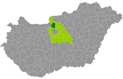
 Location of the district in Hungary |
|
| Basic data | |
| Country | Hungary |
| County | pest |
| Seat | Szentendre |
| surface | 326.6 km² |
| Residents | 79,144 (January 1, 2016) |
| density | 242 inhabitants per km² |
The Szentendre District ( Hungarian Szentendrei járás ) is a district in the north of the central Hungarian Pest County . In the north and east, the Danube ( Duna in Hungarian ) forms the border with the districts of Szob , Vác and Dunakeszi . In the southwest of the county borders Szentendre to the county Pilisvörösvár , the west by the district Esztergom from Komárom-Esztergom . In the south, the provincial capital Budapest is affected for about nine kilometers.
history
The district emerged unchanged during the Hungarian administrative reform in early 2013 as the successor to the small area of the same name (Hungarian Szentendrei kistérség ).
Community overview
The Szentendre District has an average municipality size of 6,088 inhabitants on an area of 25.12 square kilometers. The population density is above the county value. The district seat is located in the largest city, Szentendre , in the southeast of the district.
| 13 municipalities | status | Origin small area |
population | Area (km²) | Population density (inh / km²) |
||
|---|---|---|---|---|---|---|---|
| October 01, 2011 | 01/01/2013 | 01/01/2016 | |||||
| Budakalász | city | Szentendre | 10,619 | 10,450 | 10,673 | 15.17 | 703.6 |
| Csobánka | local community | Szentendre | 3,153 | 3,178 | 3,206 | 22.76 | 140.9 |
| Dunabogdány | local community | Szentendre | 3,037 | 3.113 | 3,105 | 25.50 | 121.8 |
| Kisoroszi | local community | Szentendre | 927 | 946 | 943 | 10.94 | 86.2 |
| Leányfalu | Large community | Szentendre | 3,385 | 3,483 | 3,557 | 15.37 | 231.4 |
| Pilisscent candle | local community | Szentendre | 2,259 | 2,193 | 2.114 | 17.21 | 122.8 |
| Pilisszentlászló | local community | Szentendre | 1,223 | 1,193 | 1,161 | 17.75 | 65.4 |
| Pócsmegyer | local community | Szentendre | 1,859 | 1.919 | 2,047 | 13.08 | 156.5 |
| Pomáz | city | Szentendre | 16,622 | 16,445 | 16,764 | 49.03 | 341.9 |
| Szentendre | city | Szentendre | 25,310 | 25,274 | 25,802 | 43.82 | 588.8 |
| Szigetmonostor | local community | Szentendre | 2,202 | 2,235 | 2,345 | 23.51 | 99.7 |
| Tahitótfalu | local community | Szentendre | 5,488 | 5,496 | 5,585 | 39.17 | 142.6 |
| Visegrád | city | Szentendre | 1,718 | 1,795 | 1,842 | 33.27 | 55.4 |
| Szentendre district | 77,802 | 77,720 | 79.144 | 326.58 | 242.3 | ||
swell
PDF and XLS files: 2011
Census :
2013:; 2016:
Individual evidence
- ↑ KSH: 2011. Évi Népszámlálás. In: 3. Területi adatok. KSH, accessed on December 23, 2016 (Hungarian, also via: http://www.terezvaros.hu/testuleti/nepsz2011-3/pdf/nepsz2011_03_13.pdf ).
- ↑ KSH: Regional data - Pest county. KSH, accessed on December 23, 2016 (English, 4th Data on Localities).
- ↑ KSH: Gazetteer of Hungary, 1st January, 2013. KSH, accessed April 15, 2017 (Hungarian / English).
- ↑ KSH: Gazetteer of Hungary, 1st January, 2016. KSH, accessed April 15, 2017 (Hungarian / English).