
Krimmler Achental
| Krimmler Ache | ||
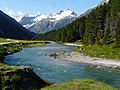
 Krimmler Ache with the Hölzlahner Alm |
||
| Data | ||
| location | Salzburg , Austria | |
| River system | Danube | |
| Drain over | Salzach → Inn → Danube → Black Sea | |
| source | On the Krimmler Törl 47 ° 6 ′ 1 ″ N , 12 ° 16 ′ 20 ″ E |
|
| Source height | approx. 2100 m above sea level A. | |
| muzzle | In Vorderkrimml in the Salzach Coordinates: 47 ° 14 '13 " N , 12 ° 11' 54" E 47 ° 14 '13 " N , 12 ° 11' 54" E |
|
| Mouth height | approx. 905 m above sea level A. | |
| Height difference | approx. 1195 m
|
|
| Catchment area | 110.7 km² | |
| Drain |
NNQ MNQ MQ MHQ |
200 l / s 356 l / s 5.61 m³ / s 57.2 m³ / s |
| Right tributaries | Rainbach, Windbach | |
| Communities | Krimml | |
| Krimml waterfalls | ||
The Krimmler Achental is a right side valley of the Salzach Valley in Pinzgau ( State of Salzburg , Austria ); the Krimmler Ache flows through it.
Location and landscape
The Krimmler Achental forms the border between the Zillertal Alps in the west and the Venediger group in the east, which is already part of the Hohe Tauern .
The valley begins above Krimml with the Krimml waterfalls and extends to the end of the valley at the Krimmlerkees at the Dreiherrenspitze ( 3499 m above sea level ). The Krimmler Ache rises at an altitude of around 2500 m, on the Krimmler Törl ( 2787 m above sea level ) to the east- facing Obersulzbachtal .
From the Krimmler Tauernhaus to the west, the Rainbachtal opens up from the Reichenspitze ( 3303 m above sea level ) and Rainbachspitze ( 3129 m above sea level ), and at the Äußere Unlaßalm the Windbachtal , both of which lead southwest into the Zillertal Alps.
history
The valley has always been of particular importance as part of transalpine traffic routes: the two routes through the Krimmler Achental over the Birnlücke ( 2671 m above sea level ) and the Krimmler Tauern ( 2634 m ) over the Windbachtal into the South Tyrolean Ahrntal are ancient alpine crossings that already exist were used by the Romans .
- For earlier history see: History of the Krimmler Tauernhaus .
The first tourist hiking trails were laid out on August 21, 1879 by the Austrian Alpine Association . In the lower area, the hiking trail follows the waterfall trail built in 1900 along the Krimml waterfalls.
There used to be border controls at both crossings into the Ahrntal valley on the border to South Tyrol , Italy .
Settlement, use and traffic


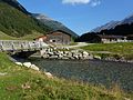
The Krimmler Achental is not populated with the exception of the Krimmler Tauernhaus in the middle of the valley , a year-round inn with its own farm and dairy . The valley is used as an alpine pasture region from the steep step at the beginning . Over 15 alpine pastures extend over the valley, all of which are located in the valley floor. Some of these pastures are used by South Tyrolean farmers from the Ahrntal , who drive their cows back over the Krimmler Tauern in autumn and who acquired the pastures between 1812 and 1873. Two other alpine pastures are located in the lower area of the two side valleys of the Windbach and Rainbachtals that branch off to the west.
A road through the valley that is closed to public traffic branches off shortly after the second bend from the Gerlos pass road and reaches the valley floor through a 300 m long, unlit tunnel in the area of the upper steep step. The road ends at the valley station of the material cable car to Warnsdorfer Hütte . You can also get there with a mountain bike or a minibus ( national park taxi ). The Warnsdorfer Hütte is located at the head of the valley, almost 500 m above the valley floor.
Individual evidence
- ↑ a b Austrian Alpine Association, Warnsdorf / Krimml section: hydrological data for the Krimmler Ache gauge ( memento from March 24, 2015 in the Internet Archive )
- ↑ The Wasserfallweg , ÖAV Warnsdorf-Krimml, accessed on January 1, 2018.
- ↑ Gebhard Kirchler: Ahrntaler Almen in the Krimmler Achental . St. Johann in Ahrn 2018.
- ↑ Krimmler Achental , homepage of the Hohe Tauern National Park , accessed on January 1, 2018.
- ↑ Krimmler Achental on bergfex.at, accessed on January 1, 2018.
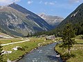
Krimmler Ache (approx. 2 km below the Tauernhaus)
Krimmler Ache with the outer Unlassalm
Krimmler Ache with Jaidbachalm

Outer Keesalm with Krimmler Ache and Krimmler Kees


Web links

Cadastral municipality: Krimml
Locations: Hochkrimml | Oberkrimml | Unterrimml
Village:
Krimml |
Rotten:
Wood rat •
Oberkrimml |
Settlements:
Hochkrimml •
Nothdorf |
Scattered houses:
Krimmler Achental •
Wildgerlostal
Other locations:
Duxeralm •
Filzstein •
Gerlosplatte •
Krimmler Tauernhaus •
Toll •
Richterhütte •
Warnsdorfer Hütte •
Zittauer Hütte
Counting district: Krimml