La Follette (Tennessee)
| La Follette | ||
|---|---|---|
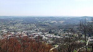
 View from the Cumberland Mountains to La Follette |
||
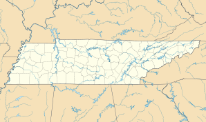
| Location in Tennessee | ||
|
|
||
| Basic data | ||
| Foundation : | 1897 | |
| State : | United States | |
| State : | Tennessee | |
| County : | Campbell County | |
| Coordinates : | 36 ° 23 ′ N , 84 ° 7 ′ W | |
| Time zone : | Eastern ( UTC − 5 / −4 ) | |
|
Inhabitants : - Metropolitan Area : |
7,456 (as of 2010) 698,030 (as of 2010) |
|
| Population density : | 591.7 inhabitants per km 2 | |
| Area : | 12.6 km 2 (approx. 5 mi 2 ) | |
| Height : | 327 m | |
| Postal code : | 37766 | |
| Area code : | +1 423 | |
| FIPS : | 47-40180 | |
| GNIS ID : | 1652480 | |
La Follette (also LaFollette ) is a small town (with the status " City ") and the largest town of Campbell County in the US -amerikanischen State Tennessee . In 2010 La Follette had 7456 inhabitants, the number of which decreased to 7251 by 2013.
La Follette is part of the Knoxville Metropolitan Statistical Area , the metropolitan area around the city of Knoxville .
geography
La Follette is located in northeast Tennessee on the southwestern edge of the Cumberland Mountains , part of the Appalachian Mountains . The city lies on both sides of the Big Creek , which forms part of the Mississippi basin through the Clinch River , the Tennessee River and the Ohio . The Tennessee- Kentucky border runs approximately 35 km north.
The geographical coordinates of La Follette are 36 ° 22'58 "north latitude and 84 ° 07'12" west longitude. The urban area extends over an area of 12.6 km².
Neighboring villages to La Follette are Fincastle (7.4 km northeast), Rocky Top (15.3 miles south), Jacksboro (8.4 km southwest) and Caryville (14.1 km in the same direction).
Knoxville city center is 39 miles south-southeast. The nearest other major cities are Charlotte in North Carolina (427 km east-southeast), Georgia's capital Atlanta (369 km south), Chattanooga (237 km southwest), Tennessee's capital Nashville (303 km west), Louisville in Kentucky (329 km northwest) and Lexington in Kentucky (223 km north).
traffic
The Interstate Highway 75 runs north-south a few kilometers west of La Follette over. The US Highway 25 W , and the Tennessee State Highway 9 and 63 meet in the center of La Follette. All other roads are subordinate country roads, some unpaved roads and inner-city connecting roads.
In the northeast-southwest direction runs a railway line for the freight traffic of the CSX Transportation through the urban area of La Follette.
With the Campbell County Airport is located 6.8 km southwest of the city center of La Follette a small airfield for general aviation . The nearest commercial airport is 83 km south to McGhee Tyson Airport in Alcoa , south of Knoxville.
| Population development | |||
|---|---|---|---|
| Census | Residents | ± in% | |
| 1900 | 306 | - | |
| 1910 | 2816 | 820.3% | |
| 1920 | 3056 | 8.5% | |
| 1930 | 2637 | -13.7% | |
| 1940 | 4010 | 52.1% | |
| 1950 | 5797 | 44.6% | |
| 1960 | 6204 | 7% | |
| 1970 | 6902 | 11.3% | |
| 1980 | 8198 | 18.8% | |
| 1990 | 7192 | -12.3% | |
| 2000 | 7926 | 10.2% | |
| 2010 | 7456 | -5.9% | |
| 2013 estimate | 7251 | -2.7% | |
| 1900-2000 2010-2013 | |||
population
According to the 2010 census , La Follette had 7456 people in 3096 households. The population density was 591.7 inhabitants per square kilometer. Statistically, 2.32 people lived in 3096 households.
The racial the population was composed of 97.0 percent white, 0.4 percent African American, 0.3 percent Native American, 0.2 percent Asian and 0.4 percent from other ethnic groups; 1.7 percent were descended from two or more races. Regardless of ethnicity, 1.5 percent of the population was Hispanic or Latino of any race.
22.1 percent of the population were under 18 years old, 58.7 percent were between 18 and 64 and 19.2 percent were 65 years or older. 53.9 percent of the population were female.
The average annual income for a household was 21,631 USD . The per capita income was $ 13,310. 38.9 percent of the population lived below the poverty line.
Known residents
- J. Will Taylor (1880-1939) - Republican member of the US House of Representatives (1919-1939) - lived and is buried in La Follette for most of his life
Individual evidence
- ↑ a b c American Fact Finder. Retrieved February 19, 2015
- ↑ Distance information according to Google Maps. Accessed on February 19, 2015
- ↑ AirNav.com - Campbell County Airport Accessed on February 19, 2015
- ^ US Decennial Census. Retrieved February 19, 2015
