Landgraf-Carl Canal
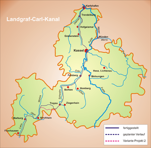
Landgrave Carl von Hessen-Kassel , who ruled from 1670 until his death in 1730, initiated the planning of a shipping route between the Weser and Lahn at the beginning of the 18th century . The canal's starting point was to be the Huguenot town of Sieburg , which he founded in 1699 ( Carlshafen from 1717 , Karlshafen from 1935 , Bad Karlshafen since 1977 ). In fact, the ambitious project between Karlshafen and Hümme was implemented as the Landgraf-Carl Canal between 1710 and 1723 , but only continued as far as the Schöneberg near Hofgeismar until Carl's death in 1730 . After that, the idea of a Central-Germany connection exclusively through Hessian territory was dropped. The 19.6-kilometer section of the canal with its engineering structures can still be seen today.
history
Since the Middle Ages , the Diemel has been navigated by barges specially built for the low water levels of the river . The Diemelkahn was 10 to 12 meters long and 1.20 meters wide at the bottom. The distance between the upper beltlines was 1.50 meters. The boat with its flat bottom was only 0.60 meters deep. Its carrying capacity was about 6 tons. Bow and stern were pulled and ran pointed to Steven to. The cargo was covered with tarpaulin. The control rudder could be relocated when changing voyages in cramped conditions. The barges were uphill towed , they drove down the valley with the flow . The cargo was transshipped between Weser ships and Diemel barges at the mouth of the Diemel in the Weser.
Landgrave Carl von Hessen-Kassel, an enlightened prince and supporter of mercantilism, established his city on the Weser as an industrial and commercial city at this transhipment point . This city foundation was favored by the admission of Huguenots and Waldensians , who had to leave their homeland because of their faith. The city, which was planned to be laid out at the mouth of the Diemel, was to become a transshipment point for ship goods in order to circumvent the stacking rights of the Brunswick city of Münden (today Hann. Münden ). To achieve this goal, a canal should lead from Karlshafen to Kassel . It flows into the Lahn at Marburg and was also intended to connect the Weser and Rhine.
As early as the 17th century, numerous merchandise reached the transshipment point in Karlshafen by water, such as fruit and grain from the Hildesheimer Börde , beer from Einbeck , cheese from Holland , stockfish and oil from Sweden and cloth from England . After Kassel everything had to take the waterway up the Weser and Fulda via Münden, which is subject to high tariffs. This also applied to the gray-colored Weser hard sandstone , which was broken close to the surface in the area around Karlshafen and Trendelburg and was very popular as a floor covering and roof covering. Pottery from the Hofgeismar-Trendelburg-Warburg area was also affected by the expensive route via Münden .
planning
If you take into account the technical possibilities at the time, the project seems rather utopian from today's perspective. Denis Papin , who was in the service of the Landgrave , gave the impression that he was up to all problems with his invention of the double-chamber lock , with which a possible water shortage when crossing the watershed could have been remedied. The work by the mechanic and mathematician Jacob Leupold on technical details in sewer construction, published from 1724 onwards , also contributed to this.
Carl was convinced that his idea was technically feasible. A similarly ambitious project in Switzerland may have inspired him: As early as 1637, Elie Gouret , a noble Huguenot from Holland , received the concession to build a canal between Lake Neuchâtel and Lake Geneva . This Canal d'Entreroches was supposed to close the gap between the Rhone and the Rhine . It was realized starting from Lake Neuchâtel up to about 12 kilometers from Lake Geneva. However, the last expansion stage was never completed. Until 1829, the expanded section was only used for regional shipping.
The Landgraf-Carl Canal was therefore not only planned as a connection through Central Germany through the state of Hessen-Kassel, but was also intended to serve as a link in a shipping route from the North Sea to the Mediterranean. It was planned in detail, even with a branch to Warburg . On the stretch from Karlshafen via Helmarshausen and Trendelburg , the first kilometers of canal were only navigable as far as Hümme .
In 1710 the finished construction plans for the canal were presented. To overcome the Rhine-Weser watershed between Treysa and Kirchhain , two options were considered. Either the canal would have been led over the Josbach to Wohra, or over the Hatzbach. The latter route is the more likely, as there was significantly more water available. In the same year, under the direction of the engineer Friedrich Conrad, work began on expanding the Diemel for shipping.
Construction progress

In the years 1713 to 1716, work began on the construction of a harbor basin 141 meters long and 53 meters wide, the Upper Canal to connect to the Diemel, a connecting lock to the Weser measuring 50 by 6.30 meters and a drop height of 3 meters and a drawbridge (later replaced by a swing bridge) to cross the road through the lock. Two regiments were used to expand the Diemel. Colonel Burkhard Christoph Münnich reported to Landgrave Carl regularly on the construction progress. The lock builder Georg Michael Meetzma directed the work on the lock . The water level was measured with the help of markings on the lock.
In 1713, Colonel Münnich suggested further locks to overcome the mill weirs in the Diemel. The Trendelburg mill weir fed the mill ditch, whose water drove three mills. The lock was originally supposed to be right next to the mill weir, but was ultimately built as a continuation of the mill canal. Münnich also presented the landgrave with plans showing a possibility of making the Diemel navigable to Warburg. To bypass the mill weirs in this section of the Diemel, Münnich provided for another ten locks. However, Warburg refused to participate in the costs, so that the expansion of the Diemel initially ended with Stammen. Of the four planned locks to Stammen, only three were built, as a lock at the Klostermühle could be omitted in Helmarshausen due to a rescheduling. All locks were made of sandstone, had a usable length of 24.6 meters, a width of 3.45 meters, a drop height of one to three meters and were provided with wooden mortise gates .
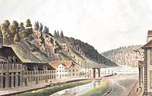
Next to the port facility, the foundation stone was laid in 1715 for a magnificent packing and customs house , which was used as the town hall after 1730. The baroque town complex of Karlshafen was built around the harbor basin .
The first ship entered the lock to the harbor in 1716 and a year later Landgrave Carl himself was the first passenger to open the new waterway to Stammen, now named after him.
In 1722 the expansion of the canal section from Stammen to Hümme was tackled next to the Esse tributary to the Diemel , so that possible floods did not have to be discharged via the canal. Below the confluence of the Esse and the Diemel, another lock was built to enter the four-kilometer-long section of the canal. Its main purpose was to keep water in the canal up to the lock in Hümme. In 1723 this section was opened for navigation, but only actually navigated with difficulty (too low water level) for four years. Shipping also struggled with this problem on the Karlshafen – Hümme section and initially had to be stopped.
To remedy the situation, it was necessary to continue building the canal to Kassel. In 1729 the canal led to the Schöneberg shortly before Hofgeismar. The Hümme-Schöneberg section was never used.
Cessation of construction
With the death of the landgrave in 1730, work on the canal ended. Shipping on the Landgraf-Carl Canal and the Diemel was not resumed.
The necessity of a freight connection from Kassel to Karlshafen was also recognized by the rulers who followed Carl and realized in 1848 with the opening of the Carlsbahn Hümme-Karlshafen as part of the Kurfürst-Friedrich-Wilhelms-Nordbahn from Kassel to Warburg. The course of the Carlsbahn followed the Landgraf-Carl Canal almost exactly. The railway line was shut down in 1986.
Relics
In Bad Karlshafen, the port lock with the lock gate on the Weser side and the large port basin have been preserved. The port-side gate of the lock has been replaced by a concrete wall to protect against flooding in the Weser. The Upper Canal branches off from the southern corner of the harbor basin in the direction of Diemel, and follows it to the side until shortly before Helmarshausen until it is integrated into the river. Here are the remains of the old fortifications .
The canal leaves the Diemel in Helmarshausen. Remnants of the wall can still be seen from the lock, which was originally built at this point, the rest is built over by a small hydroelectric power station . From the power station, the canal runs straight for about one kilometer towards the Diemel, which it reaches again on the western outskirts of Helmarshausen.
In Trendelburg, the Landgraf-Carl Canal led directly past the more than 400 year old Landgrave Mill Conradi . Part of the canal with lock systems still exists. The mill has been expanded into an information center on the subject of water. The exhibition also looks at the history of the canal.
The course of the canal and three of the former four locks can still be seen between Stammen and Hümme.
On the Rhine-Weser watershed between Neustadt-Mengsberg and Stadtallendorf-Hatzbach, an information board marks the point where, according to the planning of 1710, the watershed should have been overcome.
EcoPfad Diemel
The EcoPfad Diemel was created from 2000 by the EcoMuseum Reinhardswald , a virtual museum that wants to make the mutual influence of nature and man tangible, along the section of the Landgraf-Carl Canal, which was completed in 1729, as a cycle and hiking path, partly on the route of the former Carlsbahn. Six of twelve information boards set up along the way provide information about the history, significance and relics of the canal.
Individual evidence
- ^ Eike Erdel: The canal from the Weser to the Rhine planned by Landgrave Karl von Hessen-Kassel. In: Schwälmer Jahrbuch 2014, 2013, p. 41 ff.
- ^ Eike Erdel: The canal from the Weser to the Rhine planned by Landgrave Karl von Hessen-Kassel . In: Schwälmer Jahrbuch 2014, 2013, p. 41 (52f.).
- ↑ EcoPfad Diemel, home
literature
- Eike Erdel: The canal from the Weser to the Rhine planned under Landgrave Karl von Hessen-Kassel . In: Schwälmer Jahrbuch 2014, 2013, pp. 41–54.
- Eike Erdel: Landgrave Karl is planning a navigable canal on the Hatzbach. In: 750 Years of Hatzbach 1262–2012. Pp. 193-196.
- Klaus Röttcher: Landgrave Karl's canal in topographical maps (= Kassel hydraulic engineering research reports and materials 4). Herkules-Verlag, Kassel 1995, ISBN 3-930150-12-3 .
- Gerd Fenner, Eva Bender: Landgrave Carl and the founding of Karlshafen 1699–1999 . Weber and Weidemeyer, Kassel 1999, ISBN 3-925272-41-0 ( The region meets - the region remembers ).
- Dietmar Reske: The Rhine-Rhône Canal from a regional and supraregional perspective (= Frankfurt economic and socio-geographic writings 33). Institute for Economics and Business Social geography Frankfurt am Main 1980.
- Harald Schmidt (Ed.): Search for traces - the history of Trendelburg . Kassel University Press, Kassel 2004, ISBN 3-89958-530-5 .


