
Neckarburken forts
| Neckarburken Fort (West Fort) | |
|---|---|
| limes | ORL 53 ( RLK ) |
| Route (RLK) | ORL route 10 Neckar-Odenwald-Limes Odenwald line |
| Dating (occupancy) |
trajanic up to max. 159 ad |
| Type | Cohort fort |
| unit | a) unknown cohort b) Cohors III Aquitanorum equitata civium Romanorum |
| size | 131.5 × 158 m (= 2.1 ha) |
| Construction | a) wooden fort b) stone fort |
| State of preservation | Castle overbuilt, bathroom restored |
| place | Elztal- Neckarburken |
| Geographical location | 49 ° 22 ′ 36 " N , 9 ° 10 ′ 13" E |
| height | 175 m above sea level NHN |
| Previous | Small fort Trienz (north) |
| Subsequently |
Small fort Gundelsheim (south) Small fort Duttenberg (south) |
The Roman forts of Neckarburken are located in the area of the locality of the same name Neckarburken , a district of the Elztal municipality in the Neckar-Odenwald district . Even if the (one) Neckarburken fort is often mentioned in the literature and on various websites , it is nevertheless about two different and spatially separate forts of the same time, the West Fort and the East Fort . Both belong to the older Odenwald line of the Neckar-Odenwald-Limes and were occupied from around the year 100 AD to 159 at the latest, the east fort possibly a little longer.
A vicus was located between the two forts and west of the cohort fort . Nothing can be seen of him today. The grave fields have not yet been reliably located.
Research history

_2012-09-30_078.jpg)
The pioneers of archeology and antiquity such as Karl Wilhelmi suspected a fort in Neckarburken early on. Already at the beginning of the 19th century, an above-average accumulation of surface finds of Roman provenance in the area of Neckarburken was noticed. In 1808, a consecration stone erected by the scribes of the cohort for Minerva and the emperor and silver coins were found. In 1810, extensive Roman masonry was exposed, smashed into pieces by the ignorant population and "disposed of" in the Elz. In 1850 a relief with a winged, naked figure was found, which may be a tombstone depicting Cupid . The first excavations were carried out in 1881 by the Mannheimer Altertumsverein at the east fort . Systematic investigations of both forts were carried out by the Imperial Limes Commission between 1892 and 1894. Further archaeological activities, often as emergency excavations in connection with urban or road construction measures, took place in the second half of the 20th century.
Westkastell (cohort fort)
The west fort is located immediately south of the federal highway 27 in the area of the southeastern center of Neckarburken. This camp is a rectangular cohort fort of about 20,800 m² in size, which was surrounded by a ditch about 5 m wide and a good 1.60 m deep. Overall, a wood-earth construction phase and a stone fort are considered secured. The Porta praetoria of the four-door structure was a good twice as wide as the other gates and faced east, towards the Limes, which ran around 300 m away. From the internal structures, the Principia (staff building) with the flag sanctuary (Aedes) as well as a structure interpreted as a gun platform and a small bathing building probably belonging to the praetorium (commandant's residence) could be detected. It is possible that the two last-named buildings were only erected after the fort had been abandoned and served civilian purposes. The fort area is largely built over, so that no traces are visible in the area.

Floor plan of the west fort
(excavations 1892–1894)
Floor plan of the principia of the west fort
(excavations 1892–1894)


Troop
It is not known by which cohort (unit of about 480 men) the fort was built and used in the first time. A Cohors III Aquitanorum equitata civium Romanorum (3rd partially mounted Aquitan cohort of Roman citizenship) is documented for the later period . Her presence in the early days of the Neckarburken camp is ruled out in German specialist literature, as she was stationed in the Stockstadt fort in the Trajan period .
Fort bath
About 40 m east of the NE corner of the fort, directly on the B 27, is the fort bath, which the Baden-Württemberg State Monuments Office was able to investigate in detail in 1974 and 1975. All typical building parts of a Roman bath were proven, as well as lead water pipes and a sewer system. The northern part of the bath is disturbed by the course of the main road, the southern area has been restored and can be visited.
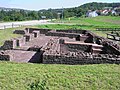
Restored foundations of the cohort bath

Floor plan of the cohort bath
(excavations 1892–1894)


Ostkastell (numerus fort)
| Neckarburken Fort (East Fort) | |
|---|---|
| limes | ORL 53 ( RLK ) |
| Route (RLK) | Neckar-Odenwald-Limes |
| Dating (occupancy) |
Trajan until around 159 AD |
| Type | Numerus fort |
| unit | Numerus Brittonum Elantiensium |
| size | 80 × 80 m (= 0.64 ha) |
| Construction | a) wooden fort b) stone fort |
| State of preservation | West gate restored, bathroom not visible |
| place | Elztal- Neckarburken |
| Geographical location | 49 ° 22 ′ 40 " N , 9 ° 10 ′ 26" E |
| height | 175 m above sea level NHN |
| Previous | Small fort Trienz (north) |
| Subsequently |
Small fort Gundelsheim (south) Small fort Duttenberg (south) |
The Ostkastell von Neckarburken is an approximately 6400 m², three-gate numerus fort in the form of an irregular square. The Porta Praetoria was oriented to the north towards the Elz . The oldest evidence suggests that the fort was built in the Trajan period. It is likely to have gone through all the construction phases typical of the numerus camps of the Odenwald Limes, as demonstrated, for example, for the forts in Würzberg and Hesselbach . A building inscription from the Porta principalis sinistra (east gate) can be dated to the period between 145 and 161 AD . Through this inscription a number stationed there , the Numerus Brittonum Elantiensium (Numerus der Elzbrittonen) is reliably proven.
Immediately in front of the Porta Praetoria in the north, the presumed grave relief with a depiction of Cupid was found, so that it was assumed that a Neckarburken cemetery could have been in this area.
The End
It is possible that the Neckarburken numerus fort was still occupied for some time after the Limes had moved around 159. The next location of the Numerus Brittonum Elantiensium was most likely the annex of the Osterburken cohort fort. This was built between 185 and 192 and fulfilled logistical functions in the hinterland of the border. After the eastern fort in Neckarburken was closed, a civil building, probably a villa rustica , was placed in the area.
The west gate of Neckarburken's east fort is preserved and can be viewed directly on the B27.

Restored foundations of the Porta Principalis Sinistra of the numerus fort

Floor plan and detailed studies of the numerus fort
(excavations 1892–1894)


Fort bath

AO: Römermuseum Osterburken
The associated fort bath is located about 70 m northwest of the NW corner of the numerus fort. It was only discovered in 1982 during canal construction work. Under the supervision of the then Centurion of the Elzbrittons, Veranius Saturninus , the bath underwent a considerable expansion in 158, which could speak for a military use of the fort beyond 159. Nothing can be seen of the bathing building in the area.
context
The combination of two camps, a larger one with a cohort or Ala and a smaller one with a Numerus or an Exploratio , is not an isolated case in the German Limes. There are similar combinations in Murrhardt and Osterburken, for example . While the larger auxiliary units were also part of the Roman movement army and thus stayed elsewhere during the duration of campaigns, the smaller number units were permanently on site, so that permanent surveillance of the Limes was guaranteed even in times of war.
Museum at the Odenwald Limes
The museum at the Odenwald Limes is housed in the former town hall of Neckarburken . In addition to information and finds on the general history of the Odenwald Limes, the Neckarburken castles are of course also presented here. The small museum is only open on Sunday afternoons between April and October. Visitors to the museum also have the opportunity to tour the neighboring church.
Limes course between the forts of Neckarburken and the small fort Duttenberg
Traces of the Limes structures between the forts of Neckarburken and the small fort Duttenberg:
| ORL | Name / place | Description / condition |
|---|---|---|
| ORL 53 | Neckarburken forts | see above |
| Wp 10/62 | "On the ingot" |
The stone tower had been excavated by a farmer from Neckarburken before 1893. The Imperial Limes Commission was able to identify bricks, mortar and shards of pottery through a probe.
The location was chosen so that from here the Elz Valley and the Limes section running in a northerly direction up to the watchtower Wp 10/56 could be seen. A bump that can still be seen in the area today may be related to the former tower site. |
| Wp 10 / 62a | "Eulberg" |
Part of the stone tower broken off by the property owner. On the north side, 95 cm thick masonry was still 70 cm high. The southern half of the tower is probably still hidden under the mound.
The view from this tower point must have extended to the north as far as Wp 10/49. |
| Wp 10/63 | "In the street fields" |
The stone tower was excavated by the Reich Limes Commission in 1894. Only the lower layers of the foundation remained. At 5.50 m by 5.56 m, it had an almost square floor plan, its thickness fluctuating between 0.93 m and 1.15 m. During a site inspection in 1982, a fragment of the edge, a stilus (iron pen) and fragments of bricked clay were found.
The location of the tower at the topographic height point 346.2 m above sea level. NHN guaranteed an excellent all-round view. It reached in the north via Sattelbach and Robern to Wp 10/46 on the Heunenbuckel, to the east far into the Limes foreland, to the south to the northern edge of the forest areas and to the west to the confluence of the Elz into the Neckar. |
| Wp 10 / 63a | Due to the topographical conditions and the average distances between Limes watchtowers, assumed but not archaeologically proven tower location. However, in the otherwise stoneless area in question there are numerous limestones of the same type as were used in the construction of Wp 10 / 62a. | |
| Wp 10/64 | "Knopfhof" | No longer visible tower part of a stone tower that overlays an older wooden tower. |
| Wp 10/65 | "Bergfeld" | Due to the topographical conditions and the average distances between Limes watchtowers, assumed but not archaeologically proven tower locations. |
| Wp 10 / 65a | " " In the Thomasbrünnlein hallway " " | |
| Wp 10/66 | "In the Stockbrunner Feld" | |
| Wp 10/67 | "At the stone (ern) table" | Due to the average distances between Limes watchtowers, assumed but not archaeologically proven tower location. |
| Wp 10/68 | "In northern Selbach" | Only suspected, not proven archaeologically. Ernst Fabricius pointed to a round hill 50 m north of the Ulmenweg and 90 m behind the Roman road. However, this location seems to be very unsafe due to its position. |
| Wp 10/69 | "Lerchenweg" | Assumed, but not archaeologically proven location. |
| Wp 10 / 69a | "In the southern Selbach" | Only assumed, not archaeologically proven tower site. |
| Wp 10/70 | "On the Hummelberg" | |
| Wp 10 / 70a | "Foxtail" | Accepted but not proven archaeologically. |
| Wp 10/71 | "Schrammbiegelwald" | Accepted but not proven archaeologically. |
| Wp 10 / 71a | "In the cane fields" | |
| Wp 10/72 | "In the chicken gardens" | |
| Wp 10/73 | "On the Heiligenrain" | Only assumed, not archaeologically proven tower site. |
| Wp 10/74 | "In the field floor level" | Only assumed, not archaeologically proven tower site. |
| Wp 10/75 | "On the Dermuth" | |
| Wp 10/76 | "On the clipper" | |
| Wp 10/77 | "Near Duttenberg" | Only assumed, not archaeologically proven tower site. |
| Small fort Duttenberg | see main article Small fort Duttenberg |


Monument protection
The forts of Neckarburken and the mentioned ground monuments are protected as cultural monuments according to the Monument Protection Act of the State of Baden-Württemberg (DSchG) . Investigations and targeted collection of finds are subject to approval, random finds must be reported to the monument authorities.
See also
literature
- Dietwulf Baatz : The Roman Limes. Archaeological excursions between the Rhine and the Danube . 4th edition. Gebr. Mann, Berlin 2000, ISBN 3-7861-2347-0 .
- Dietwulf Baatz: Fort Hesselbach and other research on the Odenwald Limes . Gebr. Mann, Berlin 1973, ISBN 3-7861-1059-X , (Limes research, volume 12)
- Ernst Fabricius , Felix Hettner , Oscar von Sarwey (ed.): The Upper Germanic-Raetian Limes of the Roemerreich . Department A, Volume 5: Route 10 (The Odenwald Limes from Wörth am Main to Wimpfen am Neckar), 1926, 1935.
- Philipp Filtzinger (Ed.): The Romans in Baden-Württemberg . 3. Edition. Theiss, Stuttgart 1986, ISBN 3-8062-0287-7 .
- Egon Schallmayer : The Odenwald Limes. Along the Roman border between the Main and Neckar. Theiss, Stuttgart 2010, ISBN 978-3-8062-2309-5 , pp. 135-146.
- Egon Schallmayer (Ed.): The Odenwald Limes. Latest research results. Contributions to the scientific colloquium on March 19, 2010 in Michelstadt . Saalburgmuseum, Bad Homburg 2012, ISBN 978-3-931267-07-0 (Saalburg-Schriften, 8).
- Karl Schumacher in The Upper Germanic-Raetian Limes of the Roemerreiches (Eds. Ernst Fabricius, Felix Hettner, Oscar von Sarwey): Department B, Volume 5, Fort No. 53 / 53.1 (1898)
Web links
Remarks
- ↑ a b c The conventional starting date of the year 100 (± 5) is based on the results of the excavations that Dietwulf Baatz carried out in the Hesselbach fort between 1964 and 1966 . It is essentially based on the evaluation of the sigillates found in the process (cf. the corresponding section in the Hesselbach article and Dietwulf Baatz: Fort Hesselbach and other research on the Odenwald Limes. Gebr. Mann, Berlin 1973, ISBN 3-7861-1059-X , ( Limesforschungen, Volume 12), pp. 85-96). In more recent literature, an initial dating of the Hesselbach fort and the entire Odenwald Limes to the period 107/110 is given preference. This dating approach is not based on new excavation findings, but on a statistical reassessment of the coin finds from all forts of the Upper Germanic-Raetian Limes, which the archaeologist Klaus Kortüm presented for the first time in 1998 and on which some authors of the more recent literature now rely. (cf. Klaus Kortüm: On the dating of the Roman military installations in the Upper German-Raetian Limes area . In: Saalburg-Jahrbuch. 49, 1998. Zabern, Mainz 1998, pp. 5–65 and Egon Schallmayer : Der Limes. History of a border . Beck, Munich 2006, ISBN 3-406-48018-7 , pp. 49–52 and pp. 54f.)
- ↑ The coordinate in the head of the article refers to the west fort.
- ↑ CIL 13, 06489 : Minervae / pro salute / Imp (eratoris) n (ostri) / librari (i) .
- ↑ a b Francisca Feraudi-Gruénais, Renate Ludwig: Heidelberger Roman stones. Sculptures, architectural parts and inscriptions in the Kurpfälzisches Museum Heidelberg. Universitätsverlag Winter, Heidelberg 2017, ISBN 978-3-8253-6693-3 , p. 100.
- ^ Official website of the Mannheimer Altertumsverein
- ↑ ORL B 5, castles No. 53 and 53.1, p. 1f.
- ↑ Today's Sulzbacher Strasse and Schillerstrasse run roughly where the west and south walls used to be, so Bürgstrasse, offset slightly to the south, runs right through the middle of the fort area.
- ↑ Dietwulf Baatz: On the dating of the bath at the Limeskastell Stockstadt. In: Bavarian history sheets . 34, 1969, pp. 63-75.
- ↑ Karl Schumacher still assumes in 1898 that the east gate is Porta Praetoria (ORL, Section B, No. 53 / 53.1. The forts near Neckarburken . K. Schumacher (1898).), Baatz contradicts him in this regard.
- ↑ Heidelberg Epigraphic Database .
- ↑ CIL 13, 6490 : Imp (eratori) Caes (ari) Tit (o) Ael (io) Had (riano) Ant (onino) Aug (usto) / Pio pon (tifici) max (imo) trib (unicia) pot ( estate) co (n) s (uli) IIII / p (atri) p (atriae) n (umerus) Brit (tonum) Elant (iensium). Translation: "To the emperor Caesar Titus Aelius Hadrianus Antoninus Pius Augustus, highest priest, endowed with tribunician power, four times consul, father of the fatherland, from the number of the Elzbrittons."
- ^ Philipp Filtzinger, Dieter Planck, Bernhard Cämmerer: The Romans in Baden-Württemberg. Theiss, Stuttgart 1986, ISBN 3-8062-0287-7 , p. 470. See also: CIL 13, 6578 , CIL 13, 06578a , CIL 13, 6582 .
- ↑ museum at the Odenwald Limes at netmuseum.de
- ↑ ORL = numbering of the Limes structures according to the publication of the Reich Limes Commission on the O bergermanisch- R ätischen- L imes
- ↑ ORL XY = consecutive numbering of the forts of the ORL
- ↑ Wp = W oh p east, watch tower. The number before the slash denotes the Limes section, the number after the slash denotes the respective watchtower.
- ↑ ORL A 5, section 10, p. 112.
- ↑ a b c Egon Schallmayer: The Odenwald Limes. Along the Roman border between the Main and Neckar. Theiss, Stuttgart 2010, ISBN 978-3-8062-2309-5 , p. 139.
- ↑ ORL A 5, section 10, p. 112f.
- ↑ a b ORL A 5, route 10, p. 113.
- ↑ a b c Egon Schallmayer: The Odenwald Limes. Along the Roman border between the Main and Neckar. Theiss, Stuttgart 2010, ISBN 978-3-8062-2309-5 , p. 140.
- ↑ ORL A 5, section 10, p. 113f.
- ↑ Egon Schallmayer: The Odenwald Limes. Along the Roman border between the Main and Neckar. Theiss, Stuttgart 2010, ISBN 978-3-8062-2309-5 , p. 141.
- ↑ Egon Schallmayer: The Odenwald Limes. Along the Roman border between the Main and Neckar. Theiss, Stuttgart 2010, ISBN 978-3-8062-2309-5 , pp. 141f.
- ↑ a b c Egon Schallmayer: The Odenwald Limes. Along the Roman border between the Main and Neckar. Theiss, Stuttgart 2010, ISBN 978-3-8062-2309-5 , p. 140.
- ^ A b Egon Schallmayer: The Odenwald Limes. Along the Roman border between the Main and Neckar. Theiss, Stuttgart 2010, ISBN 978-3-8062-2309-5 , p. 143.
- ↑ a b c d Egon Schallmayer: The Odenwald Limes. Along the Roman border between the Main and Neckar. Theiss, Stuttgart 2010, ISBN 978-3-8062-2309-5 , p. 144.
- ^ A b Egon Schallmayer: The Odenwald Limes. Along the Roman border between the Main and Neckar. Theiss, Stuttgart 2010, ISBN 978-3-8062-2309-5 , p. 145.
- ↑ Egon Schallmayer: The Odenwald Limes. Along the Roman border between the Main and Neckar. Theiss, Stuttgart 2010, ISBN 978-3-8062-2309-5 , pp. 145f.
- ^ A b Egon Schallmayer: The Odenwald Limes. Along the Roman border between the Main and Neckar. Theiss, Stuttgart 2010, ISBN 978-3-8062-2309-5 , p. 146.