
List of places in the municipality of Aileu

The list of places in the municipality of Aileu indicates which villages are located in each Suco of the East Timorese municipality of Aileu and what geographical coordinates and altitude they have.
Maps

The municipality of Aileu

list
The administrative office of Aileu Vila

The Laulara Administrative Office
| Laulara administrative office | |||||||
|
|||||||
| Suco Cotolau | |||||||
| places | position | height | places | position | height | ||
| Laulara | 8 ° 36 '11 "S, 125 ° 35' 38" E | 642 m | Lebucucu | 8 ° 38 ′ 16 ″ S, 125 ° 36 ′ 0 ″ E | 1230 m | ||
| Suco Fatisi | |||||||
| places | position | height | places | position | height | ||
| Donfonamo | 8 ° 37 ′ 40 ″ S, 125 ° 31 ′ 39 ″ E | ? | Lebihin | 8 ° 38 ′ 37 ″ S, 125 ° 31 ′ 55 ″ E | 928 m | ||
| Sabereke | 8 ° 38 ′ 48 ″ S, 125 ° 31 ′ 40 ″ E | 905 m | |||||
| Suco Madabeno | |||||||
| places | position | height | places | position | height | ||
| Belumhatu | 8 ° 38 ′ 54 "S, 125 ° 34 ′ 11" E | 1265 m | Until now | 8 ° 38 ′ 36 ″ S, 125 ° 35 ′ 37 ″ E | 1247 m | ||
| Lisimu | 8 ° 38 ′ 30 ″ S, 125 ° 34 ′ 59 ″ E | 1247 m | Manahalu | 8 ° 38 ′ 40 ″ S, 125 ° 35 ′ 5 ″ E | ? | ||
| Manufoni | 8 ° 37 ′ 31 ″ S, 125 ° 35 ′ 2 ″ E | ? | Matapati | 8 ° 38 ′ 40 ″ S, 125 ° 34 ′ 29 ″ E | 1240 m | ||
| Turiscai | 8 ° 38 ′ 31 ″ S, 125 ° 35 ′ 37 ″ E | 1247 m | |||||
| Suco Talitu | |||||||
| places | position | height | places | position | height | ||
| Casmantutu | 8 ° 35 ′ 19 ″ S, 125 ° 37 ′ 12 ″ E | 628 m | Darlau | 8 ° 35 ′ 42 "S, 125 ° 37 ′ 56" E | 536 m | ||
| Fatuc-Hun | 8 ° 38 ′ 6 ″ S, 125 ° 36 ′ 45 ″ E | 1240 m | Kitutu | 8 ° 35 ′ 18 ″ S, 125 ° 36 ′ 34 ″ E | 527 m | ||
| Cuticle | 8 ° 36 ′ 29 ″ S, 125 ° 36 ′ 29 ″ E | 813 m | Lebuhua | 8 ° 36 ′ 25 ″ S, 125 ° 37 ′ 37 ″ E | 865 m | ||
| Quelae | 8 ° 36 ′ 46 ″ S, 125 ° 36 ′ 20 ″ E | 983 m | Talitu | 8 ° 36 ′ 37 ″ S, 125 ° 36 ′ 51 ″ E | 870 m | ||
| Talitu Lama | 8 ° 36 ′ 21 ″ S, 125 ° 37 ′ 4 ″ E | 870 m | |||||
| Suco Tohumeta | |||||||
| places | position | height | places | position | height | ||
| Fereleomela | 8 ° 38 ′ 8 ″ S, 125 ° 32 ′ 59 ″ E | 964 m | Mauliu | 8 ° 37 ′ 50 ″ S, 125 ° 32 ′ 40 ″ E | ? | ||
| Tohumeta | 8 ° 38 ′ 4 ″ S, 125 ° 32 ′ 17 ″ E | 900 m | |||||
The Lequidoe Administration Office
| Lequidoe administrative office | |||||||
|
|||||||
| Suco Acubilitoho | |||||||
| places | position | height | places | position | height | ||
| Asu Mata | 8 ° 43 ′ 19 ″ S, 125 ° 40 ′ 46 ″ E | 998 m | Biloko | 8 ° 44 ′ 43 "S, 125 ° 39 ′ 27" E | 1021 m | ||
| Cleta / Lebutun | 8 ° 43 ′ 43 ″ S, 125 ° 39 ′ 45 ″ E | ? | Quiricae / Hautoho | 8 ° 42 ′ 47 "S, 125 ° 39 ′ 50" E | ? | ||
| Urupadan | 8 ° 42 ′ 40 ″ S, 125 ° 40 ′ 5 ″ E | 1073 m | |||||
| Suco Bereleu | |||||||
| places | position | height | places | position | height | ||
| Bereleu | 8 ° 43 ′ 13 ″ S, 125 ° 41 ′ 9 ″ E | ? | Berkate | 8 ° 42 ′ 48 ″ S, 125 ° 41 ′ 37 ″ E | 960 m | ||
| Lebumetan | 8 ° 42 ′ 45 ″ S, 125 ° 41 ′ 0 ″ E | 1004 m | Lebutu | 8 ° 42 ′ 23 ″ S, 125 ° 41 ′ 51 ″ E | ? | ||
| Suco Betulau | |||||||
| places | position | height | places | position | height | ||
| Belurema | 8 ° 44 ′ 42 ″ S, 125 ° 40 ′ 6 ″ E | ? | Betulau | 8 ° 44 ′ 43 ″ S, 125 ° 39 ′ 5 ″ E | 1032 m | ||
| Suco Fahisoi | |||||||
| places | position | height | places | position | height | ||
| Aituin | 8 ° 41 ′ 24 ″ S, 125 ° 38 ′ 4 ″ E | ? | Fahisoi | 8 ° 41 ′ 31 ″ S, 125 ° 38 ′ 36 ″ E | 1177 m | ||
| Dailorluta | 8 ° 41 ′ 31 ″ S, 125 ° 39 ′ 4 ″ E | 1130 m | Daufalan | 8 ° 41 ′ 14 "S, 125 ° 37 ′ 54" E | 1208 m | ||
| Ereluli | 8 ° 41 ′ 5 ″ S, 125 ° 38 ′ 15 ″ E | ? | Lequidoe | 8 ° 41 ′ 29 ″ S, 125 ° 38 ′ 10 ″ E | 1216 m | ||
| Locotoi | 8 ° 41 ′ 39 "S, 125 ° 38 ′ 47" E | 1130 m | Tatilisame | 8 ° 41 ′ 38 "S, 125 ° 38 ′ 14" E | 1216 m | ||
| Suco Faturilau | |||||||
| places | position | height | places | position | height | ||
| Cairema | 8 ° 42 ′ 46 ″ S, 125 ° 42 ′ 36 ″ E | 913 m | Lebumeran | 8 ° 42 ′ 47 "S, 125 ° 42 ′ 53" E | 894 m | ||
| Suco Manucassa | |||||||
| places | position | height | places | position | height | ||
| Fatumer | 8 ° 42 ′ 27 ″ S, 125 ° 38 ′ 19 ″ E | 1217 m | Rematu | 8 ° 42 ′ 33 "S, 125 ° 38 ′ 17" E | 1217 m | ||
| Suco Namolesso | |||||||
| places | position | height | places | position | height | ||
| Aitoin | 8 ° 42 ′ 47 "S, 125 ° 38 ′ 50" E | 1209 m | Bilaco | 8 ° 44 ′ 22 "S, 125 ° 38 ′ 49" E | ? | ||
| Daro | 8 ° 42 ′ 47 "S, 125 ° 38 ′ 34" E | 1251 m | Gariqai | 8 ° 43 ′ 7 ″ S, 125 ° 39 ′ 15 ″ E | 1151 m | ||
| Hautbititalau | 8 ° 43 ′ 21 ″ S, 125 ° 39 ′ 25 ″ E | 1135 m | Lacabou | 8 ° 42 ′ 56 ″ S, 125 ° 39 ′ 1 ″ E | 1209 m | ||
| Maucurunamo | 8 ° 43 ′ 5 ″ S, 125 ° 38 ′ 57 ″ E | 1209 m | Serema | 8 ° 42 ′ 54 ″ S, 125 ° 39 ′ 13 ″ E | 1209 m | ||
The Remexio Administrative Office
| Remexio administrative office | |||||||
|
|||||||
| Suco Acumau | |||||||
| places | position | height | places | position | height | ||
| Aimerahun | 8 ° 36 ′ 37 ″ S, 125 ° 40 ′ 0 ″ E | 877 m | Fatumanaro | 8 ° 37 ′ 5 ″ S, 125 ° 39 ′ 55 ″ E | 918 m | ||
| Leroliça | 8 ° 37 ′ 5 ″ S, 125 ° 38 ′ 48 ″ E | 958 m | Remexio | 8 ° 36 ′ 56 "S, 125 ° 39 ′ 59" E | 918 m | ||
| Ulaen | 8 ° 38 ′ 5 ″ S, 125 ° 38 ′ 24 ″ E | 1212 m | |||||
| Suco Fadabloco | |||||||
| places | position | height | places | position | height | ||
| Lequiça | 8 ° 40 ′ 10 ″ S, 125 ° 41 ′ 16 ″ E | 860 m | Lilitei | 8 ° 40 ′ 25 "S, 125 ° 40 ′ 54" E | 912 m | ||
| Litiu | 8 ° 38 ′ 33 "S, 125 ° 40 ′ 53" E | 913 m | Manulete | 8 ° 40 ′ 19 ″ S, 125 ° 41 ′ 4 ″ E | 912 m | ||
| Tunomanu | 8 ° 39 ′ 55 ″ S, 125 ° 41 ′ 41 ″ E | 860 m | |||||
| Suco Fahisoi | |||||||
| places | position | height | places | position | height | ||
| Aitoi | 8 ° 40 ′ 23 "S, 125 ° 37 ′ 54" E | 1218 m | Bereliurai | 8 ° 38 ′ 57 "S, 125 ° 38 ′ 53" E | 1172 m | ||
| Buahun | 8 ° 38 ′ 37 ″ S, 125 ° 38 ′ 13 ″ E | 1219 m | Deruti | 8 ° 39 ′ 4 ″ S, 125 ° 38 ′ 16 ″ E | 1218 m | ||
| Maunahei | 8 ° 39 ′ 39 ″ S, 125 ° 38 ′ 25 ″ E | 1218 m | Mautoba | 8 ° 39 ′ 59 "S, 125 ° 38 ′ 42" E | 1215 m | ||
| Ritutu | 8 ° 40 ′ 4 ″ S, 125 ° 38 ′ 15 ″ E | 1215 m | |||||
| Suco Faturasa | |||||||
| places | position | height | places | position | height | ||
| Bereliço | 8 ° 38 ′ 26 ″ S, 125 ° 43 ′ 5 ″ E | 1034 m | Caitaso | 8 ° 39 ′ 40 ″ S, 125 ° 45 ′ 30 ″ E | ? | ||
| Faculau | 8 ° 39 '44 "S, 125 ° 43' 48" E | 898 m | Lebometa | 8 ° 38 ′ 51 ″ S, 125 ° 43 ′ 6 ″ E | 977 m | ||
| Luquisa | 8 ° 39 ′ 44 ″ S, 125 ° 45 ′ 54 ″ E | 877 m | Raemerhei | 8 ° 39 ′ 34 ″ S, 125 ° 45 ′ 20 ″ E | 757 m | ||
| Sibatecon | 8 ° 40 ′ 52 ″ S, 125 ° 48 ′ 24 ″ E | 308 m | |||||
| Suco Hautoho | |||||||
| places | position | height | places | position | height | ||
| Aibutihun | 8 ° 40 ′ 35 ″ S, 125 ° 40 ′ 9 ″ E | 1024 m | Lebutu | 8 ° 40 ′ 25 ″ S, 125 ° 40 ′ 41 ″ E | 963 m | ||
| Raemerhei | 8 ° 41 ′ 17 "S, 125 ° 41 ′ 26" E | 896 m | |||||
| Suco Liurai | |||||||
| places | position | height | places | position | height | ||
| Flashing label | 8 ° 34 ′ 47 "S, 125 ° 42 ′ 31" E | 635 m | Haukeo | 8 ° 34 ′ 43 ″ S, 125 ° 43 ′ 0 ″ E | 616 m | ||
| Laraluha | 8 ° 34 '42 "S, 125 ° 42' 52" E | 616 m | Manutane | 8 ° 34 '35 "S, 125 ° 42' 46" E | ? | ||
| Suco Maumeta | |||||||
| places | position | height | places | position | height | ||
| Aibana | 8 ° 40 ′ 29 ″ S, 125 ° 39 ′ 48 ″ E | 1024 m | Tuqueu | 8 ° 40 ′ 16 ″ S, 125 ° 39 ′ 22 ″ E | 1088 m | ||
| Suco Tulataqueo | |||||||
| places | position | height | places | position | height | ||
| Aicurus | 8 ° 37 ′ 3 ″ S, 125 ° 45 ′ 29 ″ E | 957 m | Fatubelar | 8 ° 37 ′ 12 ″ S, 125 ° 43 ′ 23 ″ E | 873 m | ||
| Harobuti | 8 ° 37 ′ 37 ″ S, 125 ° 46 ′ 30 ″ E | 888 m | Nunudamar | 8 ° 36 ′ 56 ″ S, 125 ° 42 ′ 35 ″ E | 838 m | ||
| Roluli | 8 ° 37 ′ 50 ″ S, 125 ° 44 ′ 26 ″ E | 941 m | Samalete | 8 ° 37 ′ 9 ″ S, 125 ° 43 ′ 4 ″ E | 849 m | ||
See also
supporting documents
The spelling of the place names follows, if available, the information on the administrative divisions in:
- Jornal da Républica with the Diploma Ministerial n. ° 199/09 ( Memento of February 3, 2010 in the Internet Archive ) (Portuguese; PDF; 323 kB)
The list of localities is created with the following maps:
- Timor-Leste GIS-Portal ( Memento from June 30, 2007 in the Internet Archive )
- UNMIT maps of the districts 2008
If the place names are spelled differently, the information from the GIS portal is followed. The other spellings for individual places can be found in the article on the individual sucos in the country.
The sea heights and coordinates were taken from:
Places listed on Global Gazetteer that are not confirmed by a map will not be included in the list.
Coordinates that are not listed on Global Gazetteer are determined with the help of Google Maps .
Individual evidence
- ↑ a b c d e f g h i j k l m n o p q r s t u v w x y z aa Google Maps
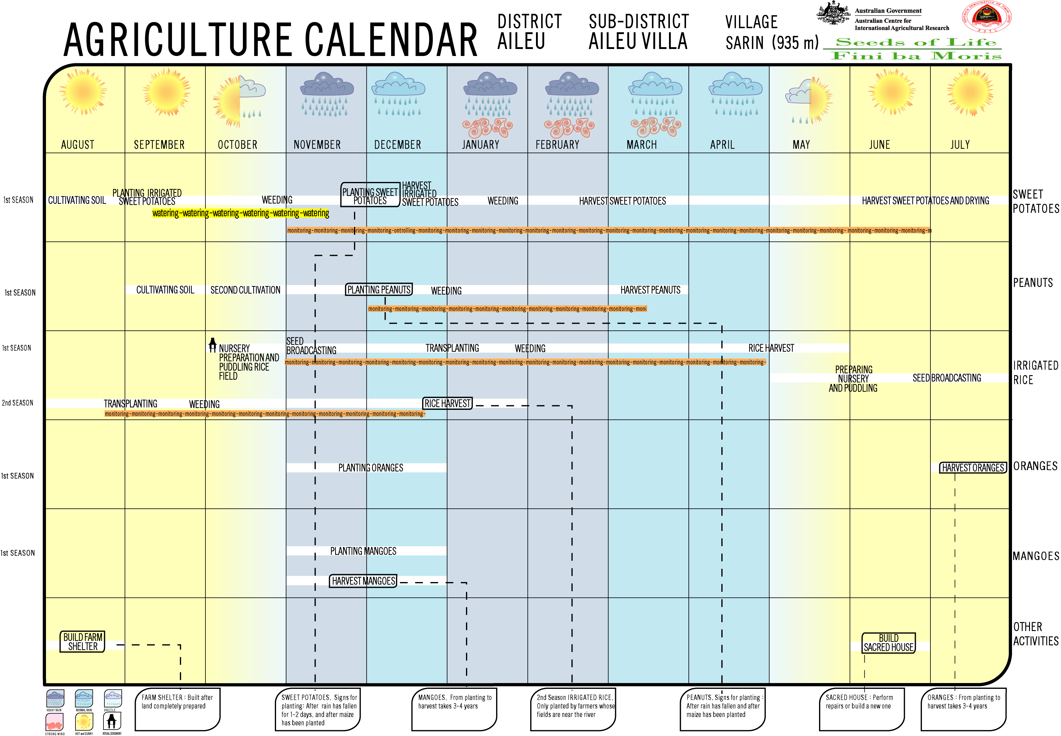
- ↑ Seeds of Life: Agriculture Calendar: Sarin (English)
The administrative borders within East Timor changed in 2015. This article must therefore be checked and updated if necessary. See New Administrative Boundaries .