
List of places in the municipality of Dili

The list of places in the municipality of Dili indicates which villages are located in each suco of the East Timorese municipality of Dili and what geographical coordinates and altitude they have. The districts of the city of Dili are also listed as places here, since from an administrative point of view in East Timor no distinction is made between independent settlements.
The changes from 2015 and 2017 have not yet been included in this list.
Maps

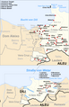
The community of Dili
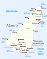
The Atauro Administrative Office
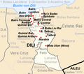
The administrative office of Cristo Rei

The Dom Aleixo Administration Office

The Metinaro Administrative Office
The Nain Feto Administration Office

Vera Cruz Administration Office


list
The Atauro Administrative Office

The administrative office of Cristo Rei
| Administrative office of Cristo Rei | |||||||
|
|||||||
| Suco Balibar | |||||||
| places | position | height | places | position | height | ||
| Balibar | 8 ° 36 ′ 0 ″ S, 125 ° 35 ′ 42 ″ E | 642 m | Fatu Loda | 8 ° 35 ′ 59 "S, 125 ° 35 ′ 29" E | 642 m | ||
| Lacoto | 8 ° 35 ′ 52 "S, 125 ° 35 ′ 9" E | 651 m | Tancae | 8 ° 35 ′ 50 ″ S, 125 ° 36 ′ 3 ″ E | 625 m | ||
| Suco Becora | |||||||
| places | position | height | places | position | height | ||
| Becusi Atas | 8 ° 33 ′ 51 ″ S, 125 ° 36 ′ 17 ″ E | 264 m | Culau | 8 ° 34 ′ 19 ″ S, 125 ° 36 ′ 18 ″ E | 307 m | ||
| Maliqueo | 8 ° 35 ′ 1 ″ S, 125 ° 36 ′ 17 ″ E | 402 m | Masau Atas | 8 ° 33 ′ 42 ″ S, 125 ° 36 ′ 27 ″ E | 265 m | ||
| Masau Bawah | 8 ° 33 ′ 25 ″ S, 125 ° 35 ′ 52 ″ E | 166 m | Mota Ulun | 8 ° 34 ′ 22 ″ S, 125 ° 36 ′ 52 ″ E | 350 m | ||
| Mota Ulun (East) | 8 ° 34 ′ 36 "S, 125 ° 35 ′ 38" E | 261 m | |||||
| Suco Bidau Santana | |||||||
| places | position | height | places | position | height | ||
| Masau | 8 ° 33 ′ 22 ″ S, 125 ° 36 ′ 3 ″ E | 166 m | Mota Claran | 8 ° 33 ′ 9 ″ S, 125 ° 35 ′ 44 ″ E | 43 m | ||
| Santana | 8 ° 32 ′ 56 "S, 125 ° 35 ′ 35" E | 43 m | |||||
| Suco Camea | |||||||
| places | position | height | places | position | height | ||
| Aidac Bihare | 8 ° 34 ′ 20 ″ S, 125 ° 37 ′ 36 ″ E | 373 m | Ailoc laran | 8 ° 33 ′ 54 ″ S, 125 ° 36 ′ 46 ″ E | 111 m | ||
| Bedois | 8 ° 33 ′ 50 ″ S, 125 ° 37 ′ 31 ″ E | 313 m | Benamauc | 8 ° 34 ′ 7 ″ S, 125 ° 37 ′ 3 ″ E | ? | ||
| Boy vacation | 8 ° 34 ′ 15 ″ S, 125 ° 37 ′ 5 ″ E | 304 m | Fatuahi | 8 ° 34 ′ 3 ″ S, 125 ° 38 ′ 4 ″ E | 272 m | ||
| Karomate | 8 ° 34 ′ 27 ″ S, 125 ° 37 ′ 3 ″ E | 350 m | Lakeru laran | 8 ° 34 ′ 59 ″ S, 125 ° 38 ′ 3 ″ E | 376 m | ||
| Lenuc Hun | 8 ° 33 ′ 48 ″ S, 125 ° 37 ′ 7 ″ E | 304 m | Susan | 8 ° 34 ′ 10 ″ S, 125 ° 38 ′ 21 ″ E | 233 m | ||
| Suco Culu Hun | |||||||
| places | position | height | places | position | height | ||
| Ailelehun | 8 ° 33 ′ 23 ″ S, 125 ° 35 ′ 6 ″ E | 38 m | Becusi Bawah | 8 ° 33 ′ 44 ″ S, 125 ° 35 ′ 45 ″ E | 166 m | ||
| Kuluhum Atas | 8 ° 33 '22 "S, 125 ° 35' 36" E | 84 m | Kuluhum Taibesi Atas | 8 ° 33 ′ 41 ″ S, 125 ° 35 ′ 36 ″ E | 84 m | ||
| Kuluhum Tengah | 8 ° 33 ′ 21 ″ S, 125 ° 35 ′ 21 ″ E | 84 m | |||||
| Suco Hera | |||||||
| places | position | height | places | position | height | ||
| Acanuno | 8 ° 33 '23 "S, 125 ° 38' 53" E | 179 m | Ailelehun | 8 ° 33 ′ 9 ″ S, 125 ° 37 ′ 25 ″ E | 302 m | ||
| Ailoc laran | 8 ° 32 ′ 49 ″ S, 125 ° 41 ′ 2 ″ E | 139 m | Airiti | 8 ° 33 ′ 16 ″ S, 125 ° 39 ′ 26 ″ E | 220 m | ||
| Bemanotolu | 8 ° 32 ′ 10 "S, 125 ° 40 ′ 43" E | 0 m | Beraka | 8 ° 32 ′ 20 ″ S, 125 ° 41 ′ 20 ″ E | 92 m | ||
| Berukulun | 8 ° 32 ′ 48 ″ S, 125 ° 40 ′ 18 ″ E | 133 m | Besidada | 8 ° 32 ′ 38 ″ S, 125 ° 40 ′ 7 ″ E | 52 m | ||
| Bidik | 8 ° 32 ′ 31 ″ S, 125 ° 39 ′ 47 ″ E | 52 m | Caremon | 8 ° 33 ′ 46 ″ S, 125 ° 39 ′ 52 ″ E | 389 m | ||
| Hera | 8 ° 32 ′ 18 ″ S, 125 ° 41 ′ 4 ″ E | 29 m | Jembatankik | 8 ° 32 ′ 38 ″ S, 125 ° 40 ′ 22 ″ E | 23 m | ||
| Lepos | 8 ° 32 ′ 32 ″ S, 125 ° 41 ′ 14 ″ E | 29 m | Liqirahu | 8 ° 32 ′ 36 "S, 125 ° 39 ′ 26" E | 65 m | ||
| Lolesu | 8 ° 32 ′ 57 ″ S, 125 ° 38 ′ 30 ″ E | 169 m | Manoroni | 8 ° 32 ′ 19 ″ S, 125 ° 40 ′ 54 ″ E | 29 m | ||
| Mantarlido | 8 ° 32 ′ 8 ″ S, 125 ° 40 ′ 17 ″ E | 0 m | Montensaun | 8 ° 32 '59 "S, 125 ° 39" 57 "E | 147 m | ||
| Mota Quic | 8 ° 33 ′ 7 ″ S, 125 ° 39 ′ 39 ″ E | 139 m | Pasir Putih | 8 ° 31 ′ 26 "S, 125 ° 42 ′ 45" E | 4 m | ||
| Raimia | 8 ° 33 ′ 49 ″ S, 125 ° 38 ′ 34 ″ E | 233 m | Sidara | 8 ° 33 ′ 44 "S, 125 ° 39 ′ 46" E | ? | ||
| Suco Meti Aut | |||||||
| places | position | height | places | position | height | ||
| 17 de April | 8 ° 33 ′ 3 ″ S, 125 ° 36 ′ 51 ″ E | ? | Areia Branca (Pasirputih) | 8 ° 31 ′ 56 "S, 125 ° 36 ′ 58" E | 134 m | ||
| Bekaril | 8 ° 32 ′ 25 ″ S, 125 ° 36 ′ 48 ″ E | 222 m | Meti Aut | 8 ° 32 ′ 46 ″ S, 125 ° 36 ′ 8 ″ E | 134 m | ||
The Dom Aleixo Administration Office
| Dom Aleixo Administration Office | |||||||
|
|||||||
| Suco Bairro Pite | |||||||
| places | position | height | places | position | height | ||
| Ailoklaran | 8 ° 33 '53 "S, 125 ° 33' 36" E | 111 m | Ailoklaran Selatan | 8 ° 34 ′ 9 ″ S, 125 ° 33 ′ 53 ″ E | 114 m | ||
| Bairro Pite | 8 ° 33 ′ 33 ″ S, 125 ° 33 ′ 35 ″ E | 18 m | Fatumeta | 8 ° 33 ′ 43 "S, 125 ° 33 ′ 11" E | 50 m | ||
| Hudilaran | 8 ° 33 ′ 28 ″ S, 125 ° 33 ′ 21 ″ E | 18 m | Cocaweed | 8 ° 33 ′ 57 ″ S, 125 ° 33 ′ 17 ″ E | 111 m | ||
| Manleu-Ana | 8 ° 34 ′ 33 ″ S, 125 ° 32 ′ 39 ″ E | 179 m | Perumnas | 8 ° 33 ′ 45 ″ S, 125 ° 33 ′ 50 ″ E | 114 m | ||
| Suco Comoro | |||||||
| places | position | height | places | position | height | ||
| 12 de Outubro | 8 ° 33 ′ 29 ″ S, 125 ° 30 ′ 44 ″ E | ? | 4 de Setembro | 8 ° 33 ′ 56 ″ S, 125 ° 32 ′ 6 ″ E | ? | ||
| Aimutin 1 | 8 ° 33 ′ 19 ″ S, 125 ° 32 ′ 48 ″ E | 50 m | Aimutin 2 | 8 ° 33 ′ 43 ″ S, 125 ° 32 ′ 50 ″ E | 50 m | ||
| Aimutin laran | 8 ° 33 ′ 38 ″ S, 125 ° 32 ′ 37 ″ E | 64 m | Badiac | 8 ° 34 ′ 17 ″ S, 125 ° 32 ′ 17 ″ E | ? | ||
| Bebonuk Metin | 8 ° 32 ′ 40 ″ S, 125 ° 32 ′ 37 ″ E | 0 m | Beduku | 8 ° 35 ′ 10 ″ S, 125 ° 31 ′ 47 ″ E | 124 m | ||
| Beto Barat | 8 ° 33 ′ 3 ″ S, 125 ° 31 ′ 25 ″ E | 0 m | Beto Timur | 8 ° 32 ′ 57 ″ S, 125 ° 31 ′ 59 ″ E | 0 m | ||
| Comoro | 8 ° 32 ′ 48 ″ S, 125 ° 31 ′ 29 ″ E | 8 m | Haslaran | 8 ° 33 ′ 44 ″ S, 125 ° 32 ′ 16 ″ E | 64 m | ||
| Kampung Baru | 8 ° 33 ′ 22 ″ S, 125 ° 31 ′ 30 ″ E | 0 m | Kelapa | 8 ° 32 ′ 32 ″ S, 125 ° 32 ′ 16 ″ E | ? | ||
| Lapangan Terbang Comoro |
8 ° 33 ′ 7 ″ S, 125 ° 31 ′ 4 ″ E | ? | Lesibutak | 8 ° 34 ′ 43 ″ S, 125 ° 32 ′ 5 ″ E | 79 m | ||
| Lih Baulelo | 8 ° 33 ′ 56 ″ S, 125 ° 30 ′ 12 ″ E | ? | Lurumata | 8 ° 33 ′ 10 ″ S, 125 ° 32 ′ 53 ″ E | 0 m | ||
| Manleuana | 8 ° 33 ′ 28 "S, 125 ° 31 ′ 43" E | 0 m | Manleu Lidun | 8 ° 34 ′ 55 "S, 125 ° 31 ′ 58" E | ? | ||
| Marinir | 8 ° 32 ′ 28 "S, 125 ° 31 ′ 58" E | 0 m | Mate Lahotu | 8 ° 32 ′ 21 ″ S, 125 ° 32 ′ 11 ″ E | ? | ||
| Merdeka | 8 ° 33 ′ 17 ″ S, 125 ° 31 ′ 54 ″ E | 10 m | Moris Foun | 8 ° 34 ′ 58 ″ S, 125 ° 31 ′ 42 ″ E | ? | ||
| Pantai Kelapa ( Praia dos Coqueiros ) | 8 ° 32 ′ 58 ″ S, 125 ° 32 ′ 27 ″ E | 4 m | Paularan | 8 ° 32 ′ 27 ″ S, 125 ° 32 ′ 13 ″ E | 0 m | ||
| Pomento | 8 ° 33 ′ 26 ″ S, 125 ° 32 ′ 17 ″ E | 64 m | Rai Nain | 8 ° 33 ′ 21 ″ S, 125 ° 32 ′ 54 ″ E | ? | ||
| São José | 8 ° 33 ′ 18 ″ S, 125 ° 32 ′ 35 ″ E | ? | São Miguel | 8 ° 33 ' S , 125 ° 33' E | ? | ||
| Suco Fatuhada | |||||||
| places | position | height | places | position | height | ||
| Fatuhada | 8 ° 33 ′ 8 ″ S, 125 ° 33 ′ 26 ″ E | 0 m | Markoni | 8 ° 32 ′ 59 ″ S, 125 ° 33 ′ 6 ″ E | 0 m | ||
| Mataruak | 8 ° 32 ′ 49 ″ S, 125 ° 33 ′ 6 ″ E | 0 m | |||||
| Suco Kampung Alor | |||||||
| places | position | height | places | position | height | ||
| Karketu | 8 ° 32 ′ 56 ″ S, 125 ° 33 ′ 40 ″ E | 0 m | Moro | 8 ° 33 ′ 8 ″ S, 125 ° 33 ′ 41 ″ E | 0 m | ||
The Metinaro Administrative Office
| Metinaro Administration Office | |||||||
|
|||||||
| Suco Mantelolão | |||||||
| places | position | height | places | position | height | ||
| See | 8 ° 32 ′ 38 "S, 125 ° 45 ′ 54" E | ? | Lebutun | 8 ° 31 ′ 59 "S, 125 ° 44 ′ 48" E | 168 m | ||
| Suco Sabuli | |||||||
| places | position | height | places | position | height | ||
| Ayatan | 8 ° 32 ′ 10 ″ S, 125 ° 44 ′ 3 ″ E | 104 m | Wenunuc | 8 ° 31 '48 "S, 125 ° 44' 37" E | 135 m | ||
| Kabura | 8 ° 31 ′ 54 ″ S, 125 ° 44 ′ 19 ″ E | 135 m | Manuleu | 8 ° 31 '52 "S, 125 ° 44' 39" E | 135 m | ||
| Metinaro | 8 ° 31 ′ 50 ″ S, 125 ° 44 ′ 41 ″ E | 135 m | Sabuli | 8 ° 31 ′ 46 ″ S, 125 ° 44 ′ 10 ″ E | 104 m | ||
| Sukaerlaran | 8 ° 31 ′ 57 ″ S, 125 ° 44 ′ 22 ″ E | 135 m | |||||
| Suco Wenunuc | |||||||
| places | position | height | places | position | height | ||
| Duyung | 8 ° 31 ′ 43 ″ S, 125 ° 45 ′ 12 ″ E | 61 m | Manleu | 8 ° 29 ′ 18 ″ S, 125 ° 50 ′ 0 ″ E | 171 m | ||
| Nelayan | 8 ° 31 ′ 23 ″ S, 125 ° 45 ′ 5 ″ E | 61 m | Priramatan | 8 ° 31 ′ 50 ″ S, 125 ° 45 ′ 4 ″ E | 168 m | ||
The Nain Feto Administration Office
| Administrative office of Nain Feto | |||||||
|
|||||||
| Suco Acadiru Hun | |||||||
| places | position | height | places | position | height | ||
| Belebato | 8 ° 33 ′ 15 "S, 125 ° 35 ′ 20" E | 84 m | Nu'u Badac | 8 ° 33 ′ 6 ″ S, 125 ° 35 ′ 20 ″ E | 43 m | ||
| Suco Bemori | |||||||
| places | position | height | places | position | height | ||
| Bemori Baba Liu Rai | 8 ° 33 ′ 36 ″ S, 125 ° 35 ′ 16 ″ E | 84 m | Bemori Central | 8 ° 33 ′ 32 ″ S, 125 ° 35 ′ 9 ″ E | 38 m | ||
| Bemori Taibesi | 8 ° 33 ′ 42 ″ S, 125 ° 35 ′ 13 ″ E | 38 m | |||||
| Suco Bidau Lecidere | |||||||
| places | position | height | places | position | height | ||
| Bairo Lecidere | 8 ° 33 ′ 6 ″ S, 125 ° 34 ′ 54 ″ E | 0 m | |||||
| Suco Gricenfor | |||||||
| places | position | height | places | position | height | ||
| Bairo Central | 8 ° 33 ′ 17 ″ S, 125 ° 35 ′ 1 ″ E | ? | Bairo dos Grilos | 8 ° 33 ′ 11 ″ S, 125 ° 34 ′ 59 ″ E | ? | ||
| Bairo Formosa | 8 ° 33 ′ 18 ″ S, 125 ° 34 ′ 50 ″ E | ? | |||||
| Suco Lahane Oriental | |||||||
| places | position | height | places | position | height | ||
| Marabia | 8 ° 34 ′ 7 ″ S, 125 ° 35 ′ 19 ″ E | 155 m | Mota Ulun (West) | 8 ° 34 ′ 25 "S, 125 ° 35 ′ 29" E | 261 m | ||
| Quintal Arbiro | 8 ° 34 ′ 3 ″ S, 125 ° 35 ′ 7 ″ E | 128 m | Taibesi | 8 ° 34 ′ 4 ″ S, 125 ° 35 ′ 31 ″ E | 155 m | ||
| Suco Santa Cruz | |||||||
| places | position | height | places | position | height | ||
| Audian | 8 ° 33 ′ 25 ″ S, 125 ° 34 ′ 54 ″ E | 38 m | Quintal Bot | 8 ° 33 ′ 51 ″ S, 125 ° 34 ′ 57 ″ E | 128 m | ||
| Quintal Qik | 8 ° 33 '36 "S, 125 ° 34" 59 "E | 38 m | |||||
Vera Cruz Administration Office
| Vera Cruz Administration Office | |||||||
|
|||||||
| Suco Caicoli | |||||||
| places | position | height | places | position | height | ||
| Borohun | 8 ° 33 ′ 37 ″ S, 125 ° 34 ′ 40 ″ E | 11 m | Caicoli | 8 ° 33 ′ 33 ″ S, 125 ° 34 ′ 23 ″ E | 11 m | ||
| Rumbia | 8 ° 33 ′ 46 "S, 125 ° 34 ′ 46" E | 128 m | |||||
| Suco Colmera | |||||||
| places | position | height | places | position | height | ||
| Colmera | 8 ° 33 ′ 23 "S, 125 ° 34 ′ 27" E | 11 m | Soslodade | 8 ° 33 ′ 17 ″ S, 125 ° 34 ′ 23 ″ E | 11 m | ||
| Suco Dare | |||||||
| places | position | height | places | position | height | ||
| Casnafar | 8 ° 35 ′ 39 ″ S, 125 ° 32 ′ 41 ″ E | 232 m | Bemarua | 8 ° 36 ′ 13 ″ S, 125 ° 33 ′ 42 ″ E | 587 m | ||
| Dare | 8 ° 35 ′ 34 ″ S, 125 ° 34 ′ 9 ″ E | 495 m | Fatu Naba | 8 ° 35 ′ 47 "S, 125 ° 34 ′ 34" E | 645 m | ||
| Laulara Lama | 8 ° 36 ′ 4 ″ S, 125 ° 33 ′ 9 ″ E | 558 m | louse | 8 ° 36 ′ 9 ″ S, 125 ° 32 ′ 56 ″ E | ? | ||
| Suco Lahane Ocidental | |||||||
| places | position | height | places | position | height | ||
| Aihanexun | 8 ° 35 ′ 2 ″ S, 125 ° 34 ′ 58 ″ E | 376 m | Koreo | 8 ° 34 ′ 43 "S, 125 ° 34 ′ 53" E | 248 m | ||
| Nahaec | 8 ° 35 ′ 28 ″ S, 125 ° 34 ′ 50 ″ E | 545 m | |||||
| Suco mascarenhas | |||||||
| places | position | height | places | position | height | ||
| Balide | 8 ° 33 ′ 54 ″ S, 125 ° 34 ′ 24 ″ E | 114 m | Bispo Medeiros | 8 ° 33 '52 "S, 125 ° 34" 42 "E | 114 m | ||
| Mascarenhas | 8 ° 34 ′ 2 ″ S, 125 ° 34 ′ 43 ″ E | 114 m | |||||
| Suco Motael | |||||||
| places | position | height | places | position | height | ||
| Aitarak | 8 ° 32 ′ 56 ″ S, 125 ° 33 ′ 57 ″ E | 0 m | Bairo Alto | 8 ° 33 ′ 18 ″ S, 125 ° 34 ′ 7 ″ E | 8 m | ||
| Bebora | 8 ° 33 ′ 12 ″ S, 125 ° 33 ′ 56 ″ E | 0 m | Farol | 8 ° 33 ′ 12 ″ S, 125 ° 34 ′ 7 ″ E | 0 m | ||
| Palapaso | 8 ° 32 ′ 59 ″ S, 125 ° 34 ′ 9 ″ E | 0 m | |||||
| Suco Vila Verde | |||||||
| places | position | height | places | position | height | ||
| Banderahun | 8 ° 33 ′ 47 ″ S, 125 ° 34 ′ 1 ″ E | 114 m | Lafandaria | 8 ° 33 ′ 39 ″ S, 125 ° 34 ′ 10 ″ E | 8 m | ||
| Mata Doro | 8 ° 33 ′ 32 ″ S, 125 ° 34 ′ 8 ″ E | 8 m | Manumeta Rahun | 8 ° 34 ′ 1 ″ S, 125 ° 34 ′ 4 ″ E | 114 m | ||
| Tuanalaran | 8 ° 33 ′ 50 ″ S, 125 ° 34 ′ 9 ″ E | 114 m | Vila Verde | 8 ° 33 ′ 27 ″ S, 125 ° 33 ′ 59 ″ E | 8 m | ||
| Virgolosa | 8 ° 33 ′ 45 ″ S, 125 ° 34 ′ 9 ″ E | 114 m | |||||
See also
supporting documents
The spelling of the place names follows, if available, the information on the administrative divisions in:
- Jornal da Républica with the Diploma Ministerial n ° 199/09 ( Memento of February 3, 2010 in the Internet Archive ) (Portuguese; PDF; 323 kB)
The list of localities is created with the following maps:
- Timor-Leste GIS-Portal ( Memento from June 30, 2007 in the Internet Archive )
- UNMIT maps of the districts 2008
If the place names are spelled differently, the information from the GIS portal is followed. The other spellings for individual places can be found in the article on the individual sucos in the country.
The sea heights and coordinates were taken from:
Places listed on Global Gazetteer that are not confirmed by a map will not be included in the list.
Coordinates that are not listed on Global Gazetteer are determined with the help of Google Maps .
The administrative borders within East Timor changed in 2015. This article must therefore be checked and updated if necessary. See New Administrative Boundaries .