List of listed objects in Ternitz
The list of listed objects in Ternitz contains the 40 listed , immovable objects of the municipality of Ternitz in the Lower Austrian district of Neunkirchen .
Monuments
| photo | monument | Location | description | Metadata |
|---|---|---|---|---|

|
Old Town Hall ObjectID : 94040 |
Rathausgasse 8 KG location : Dunkelstein |
Two-storey late historical building with domed corner tower, built around 1900, niche with Roland statue . |
ObjectID : 94040 Status: § 2a Status of the BDA list: 2020-02-29 Name: Altes Rathaus GstNr .: .144 |

|
Jubilee gym ObjectID : 93948 |
Schoellergasse 1 KG location : Dunkelstein |
ObjectID : 93948 Status: § 2a Status of the BDA list: 2020-02-29 Name: Jubiläumsturnhalle GstNr .: .133 |
|

|
Dunkelstein Primary School ObjectID : 94034 |
Triester Str. 20 KG location : Dunkelstein |
Two-storey building above a high base with Secessionist plaster decor, windows have been changed, from Otto Wagner's school . |
ObjectID : 94034 Status: § 2a Status of the BDA list: 2020-02-29 Name: Volksschule Dunkelstein GstNr .: 373/1 |
|
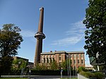
Power center (boiler house including chimney with water tank ) Edelstahlwerk Schoeller-Bleckmann ObjektID : 93949 |
Werkstrasse 2 Location KG: Dunkelstein |
ObjectID : 93949 Status : Notification Status of the BDA list: 2020-02-29 Name : Power center (boiler house including chimney with water tank ) Edelstahlwerk Schoeller-Bleckmann GstNr .: 622/28 |
|

|
Shrine Object ID: 55933 |
Peterwaldweg location KG: Dunkelstein |
ObjectID : 55933 Status: § 2a Status of the BDA list: 2020-02-29 Name: Bildstock GstNr .: 31/1 |
|
|
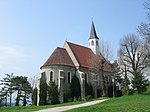
Catholic branch church hll. Peter and Paul ObjectID : 67727 |
St. Paul-Gasse KG location : Dunkelstein |
Baroque hall building above its medieval predecessor, remains of the medieval cemetery excavated from 1992, first mentioned in 1160. |
ObjectID : 67727 Status: § 2a Status of the BDA list: 2020-02-29 Name: Kath. Filialkirche hll. Peter and Paul GstNr .: .4 Saints Peter and Paul Church (Dunkelstein, Ternitz) |

|
Parsonage Object ID: 93953 |
St. Lorenzer Straße 121 KG location : Flatz |
Medieval-early modern one to two-storey building with baroque conversions around a wide courtyard |
ObjectID : 93953 Status: § 2a Status of the BDA list: 2020-02-29 Name: Pfarrhof GstNr .: .56 / 1 |

|
Catholic parish church hl. Laurentius, cemetery and walls ObjectID : 55770 |
Location KG: Flatz |
Romanesque / Gothic building with baroque changes, stately parish before 1158, since 1617 incorporated into the Neukloster Abbey - Heiligenkreuz Abbey, Romanesque north tower 12th century, Gothic choir and south side chapel from the 14th century, nave in the core Romanesque or from the 15th century. / 16. Century, 1750/52 partial new building of the nave and space breakthrough between the nave and the south chapel. |
ObjectID : 55770 Status: § 2a Status of the BDA list: 2020-02-29 Name: Catholic parish church hl. Laurentius, cemetery and walls GstNr .: .56 / 2 Saint Lawrence Church (St. Lorenzen am Steinfeld) |

|
Local chapel to the Mother of God ObjectID : 94450 |
Raglitzer Str. KG location : Raglitz |
Hall building with retracted rectangular apse and gable tab, marked 1871, street-side pilasters and gable cornice on terracotta consoles |
ObjectID : 94450 Status: § 2a Status of the BDA list: 2020-02-29 Name: Ortskapelle Zur Muttergottes GstNr .: 25/2 |

|
Spinning mill Karl Schweigl ObjectID : 94455 since 2013 |
Josef Huber-Str. 6 KG location : Rohrbach am Steinfelde |
ObjektID : 94455 Status : Notification Status of the BDA list: 2020-02-29 Name: Spinnerei Karl Schweigl GstNr .: .147 / 1; .147 / 2 |
|
|
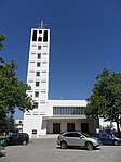
Catholic Parish Church of the Sacred Heart of Jesus ObjectID : 94013 |
Theodor-Körner-Platz KG location : Rohrbach am Steinfelde |
The parish church of Ternitz was planned by Josef Vytiska and completed in 1959, in the chancel there is a mosaic by Lois Pregartbauer . |
ObjektID : 94013 Status: § 2a Status of the BDA list: 2020-02-29 Name: Catholic parish church Heiligstes Herz Jesu GstNr .: .262 Stadtpfarrkirche Ternitz |

|
Stadthalle ObjektID : 94014 |
Theodor-Körner-Platz 2 Location KG: Rohrbach am Steinfelde |
The town hall, a multi-purpose hall in reinforced concrete construction with wooden trusses and aluminum roof, was planned by Roland Rainer and completed in 1963. |
ObjectID : 94014 Status: § 2a Status of the BDA list: 2020-02-29 Name: Stadthalle GstNr .: .264 |

|
Part of the 1st Vienna Mountain Spring Pipeline ObjectID : 131049 since 2016 |
KG location : Rohrbach am Steinfelde |
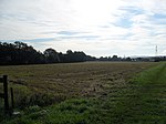
The first Viennese spring water pipeline is part of the Viennese water supply and was the first supply of Vienna with safe drinking water. After four years of construction, the 95-kilometer line was opened on October 24, 1873. Entry tower 14 is located in Rohrbach am Steinfelde (picture). |
ObjectID : 131049 Status : Notification Status of the BDA list: 2020-02-29 Name: Part of the 1st Vienna High Spring Pipeline GstNr .: 721 |
|
Find area Gfiederäcker ObjectID : 129154 |
Gfiederäcker location KG: St. Johann am Steinfelde |
ObjectID : 129154 Status : Notification Status of the BDA list: 2020-02-29 Name: Find zone Gfiederäcker GstNr .: 1195 |
|
|
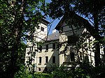
Scherz-Villa (Welzl-Villa) ObjektID : 33376 |
M.Welzl-Gasse 9 KG location : St. Johann am Steinfelde |
Built in the Wilhelminian style from 1878–1880 with elements of the Heimat style, probably based on plans by Theophil von Hansen |
ObjectID : 33376 Status : Notification Status of the BDA list: 2020-02-29 Name: Scherz-Villa (Welzl-Villa) GstNr .: .124 |

|
Neudegg ruins ObjectID : 47897 |
Dreifaltigkeitsberg KG location : St. Johann am Steinfelde |
A medieval house mountain, a small part of which has been exposed. It was perhaps the seat of the lords of Neidegg mentioned in a document in 1172. The baroque Trinity Chapel is believed to have been built on the foundation of the castle. |
ObjectID : 47897 Status : Notification Status of the BDA list: 2020-02-29 Name: Ruine Neudegg GstNr .: 266/1; 267 |

|
Former Parsonage Object ID: 33377 |
St. Johanner Straße 18 KG location : St. Johann am Steinfelde |
single-storey building from the end of the 19th century, late historic wooden door |
ObjectID : 33377 Status : Notification Status of the BDA list: 2020-02-29 Name: Former Vicarage GstNr .: .37 |
|
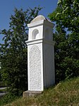
Shrine Object ID: 94080 |
Straße des 12. Februar KG location : St. Johann am Steinfelde |
Pillar shrine with niche top from the 17th century (?) At the Ternitz cemetery |
ObjectID : 94080 Status: § 2a Status of the BDA list: 2020-02-29 Name: Bildstock GstNr .: 513/1 |
|
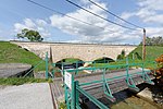
Part of the 1st Vienna Mountain Spring Pipeline ObjectID : 129021 |
Location see description KG: St. Johann am Steinfelde |
For I. HQL see the entry in KG Rohrbach am Steinfelde In KG St. Johann am Steinfelde there are: entry tower 12 ( location ), entry tower 13 ( location ), the aqueduct over a branch of the Sierning ( location , shown here), two aqueducts in quick succession, one over the Sierning ( location , location ) and, last but not least, the confluence of the branch coming from the Stixenstein source. The entry towers of this branch are numbered out of sequence, at the confluence is No. 4 ( location ), a little further up No. 3 ( location ) |
ObjektID : 129021 Status : Notification Status of the BDA list: 2020-02-29 Name: Part of the 1st Vienna High Spring Pipeline GstNr .: 893/5; 893/6; 1244/1; 1359; 1360; 1362/3; 1364/1; 1366 I. Vienna high spring water pipeline |

|
Catholic parish church hl. John the Baptist, cemetery and walls ObjectID : 69060 |
KG location : St. Johann am Steinfelde |
Late Romanesque nave with early Gothic rectangular choir, raised like a tower in the 15th century, nave redesigned with two aisles in the 16th century with late Gothic vaulting, first mentioned in 1204, vicariate in 1352, parish before 1487 and 1783 |
ObjectID : 69060 Status: § 2a Status of the BDA list: 2020-02-29 Name: Catholic parish church hl. Johannes d. T., cemetery and walls GstNr .: .55; 500/10; 500/15; 500/16 Saint John the Baptist Church (St. Johann am Steinfeld) |
|
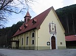
Kath. Filialkirche Mariahilf ObjectID : 94002 |
Siedinger Str. 14 KG location : Sieding |
Built in 1931/32, hall with a rectangular floor plan, saddle roof and turret, cemetery laid out at the same time as the church |
ObjectID : 94002 Status: § 2a Status of the BDA list: 2020-02-29 Name: Kath. Filialkirche Mariahilf GstNr .: 145 |

|
Local chapel St. Johannes Nepomuk ObjectID : 94003 |
at Siedinger Str. 19 KG location : Sieding |
small baroque building with a tower from the middle of the 19th century |
ObjectID : 94003 Status: § 2a Status of the BDA list: 2020-02-29 Name: Ortskapelle hl. Johannes Nepomuk GstNr .: .126 |

|
Former Dam below Stixenstein Castle ObjectID : 33640 |
Stixenstein 1 location KG: Sieding |
The medieval arch through which the street leads was used at times as a customs post for Stixenstein Castle. The built-up single-storey residential building dates from the 19th century |
ObjectID : 33640 Status: § 2a Status of the BDA list: 2020-02-29 Name: Former Dam below Stixenstein Castle GstNr .: .4 Stixenstein Castle - dam |

|
Former Farm building of Stixenstein Castle ObjectID : 94009 |
Stixenstein 2 location KG: Sieding |
The two-storey building with a crooked roof dates from the 19th century. |
ObjectID : 94009 Status: § 2a Status of the BDA list: 2020-02-29 Name: Former Farm building of Stixenstein Castle GstNr .: .5 |

|
Stixenstein Castle ObjectID : 33639 |
Stixenstein 3 KG location : Sieding |
The castle was mentioned in 1182, but is about a hundred years older. It has a square keep, the originally Gothic chapel has a hexagonal gable tower. Some windows and the gate are late Gothic. In 1547 it came into the possession of the Hoyos , a branch of which was named after it and has belonged to the City of Vienna since 1937 . After a fire in 1843 it was only partially restored. |
ObjectID : 33639 Status: § 2a Status of the BDA list: 2020-02-29 Name: Burg Stixenstein GstNr .: .3; 120; 132 Stixenstein Castle |

|
Part of the 1st Vienna High Spring Pipeline ObjectID : 129159 |
Location see description KG: Sieding |
For the I. HQL see the entry in the KG Rohrbach am Steinfelde In Sieding there is the branch of the line that transports the water from the Stixenstein spring. There are two entry towers (numbered outside the main row): No. 1 ( location ) and No. 2 ( location ). |
ObjectID : 129159 Status : Notification Status of the BDA list: 2020-02-29 Name: Part of the 1st Vienna High Spring Pipeline GstNr .: 1815; 107/2; 128; 123; 1494/1; 1719/2 I. Vienna high spring water pipeline |

|
Water reservoir of the 1st Vienna high spring water pipeline ObjektID : 94006 |
KG location : Sieding |
For I. HQL see the entry in the KG Rohrbach am Steinfelde. The Stixenstein spring was taken in the 1860s. |
ObjectID : 94006 Status: § 2a Status of the BDA list: 2020-02-29 Name: Water reservoir of the 1st Vienna high spring water pipeline GstNr .: 132 I. Vienna high spring water pipeline |
|
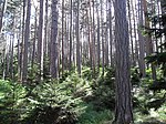
Fortified hill settlement Burgstall ObjektID : 71990 |
Burgstall location KG: Holzweg |
The extensive, fortified hilltop settlement may date from the early Middle Ages. Note: The hillside settlement extends over the cadastral communities of Holzweg and Pottschach . |
ObjectID : 71990 Status : Notification Status of the BDA list: 2020-02-29 Name: Fortified hillside settlement Burgstall GstNr .: 64/1; 66 |

|
Fortified hill settlement Burgstall ObjectID : 69057 |
Burgstall location KG: Pottschach |
The extensive, fortified hilltop settlement may date from the early Middle Ages. Note: The hillside settlement extends over the cadastral communities of Holzweg and Pottschach. |
ObjectID : 69057 Status : Notification Status of the BDA list: 2020-02-29 Name: Fortified hillside settlement Burgstall GstNr .: 993/1; 994/1; 996/1; 999/1; 1000/1; 1053; 1055; 1056; 1057; 1058/1; 1058/2; 1059; 1061/1 |
|
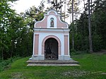
Kalvarienbergkapelle ObjektID : 94044 |
Grohmannstrasse location KG: Pottschach |
Erected in 1709, small baroque building, figures of Christ on the cross with the two Marys and John the Evangelist |
ObjectID : 94044 Status: § 2a Status of the BDA list: 2020-02-29 Name: Kalvarienbergkapelle GstNr .: 1008/2 |

|
Mount of Olives Object ID: 94043 |
opposite Grohmannstrasse 16 KG location : Pottschach |
Mount of Olives opposite the Pottschach cemetery, 18th century, restored in 2017 |
ObjectID : 94043 Status: § 2a Status of the BDA list: 2020-02-29 Name: Ölberggruppe GstNr .: 1008/2 |

|
Wayside shrine Christ on the scourge column ObjectID : 124817 |
opposite Grohmannstraße 22 KG location : Pottschach |
from the 18th century, restored in 2017 |
ObjectID : 124817 Status : Notification Status of the BDA list: 2020-02-29 Name: wayside shrine Christ on the scourge column GstNr .: 1008/2 |

|
Catholic parish church hl. Dionysius with fortified cemetery ObjectID : 55934 |
Kirchengasse 1 KG location : Pottschach |
late Gothic fortified church with a high medieval core and baroque additions (sacristy, side aisle), documented parish 1342, originally probably Romanesque hall building, around the church medieval defensive wall with walled-in loopholes |
ObjectID : 55934 Status: § 2a Status of the BDA list: 2020-02-29 Name: Catholic parish church hl. Dionysius with Wehrkirchhof GstNr .: .23 Parish Church Pottschach |

|
Parsonage Object ID: 33199 |
Kirchengasse 3 KG location : Pottschach |
Mighty two-story building with a hipped roof and a defensive storey. Arched niche with a copy of the figure of St. Dionysius. 1988 Extension by adding a new parish hall. |
ObjectID : 33199 Status: § 2a Status of the BDA list: 2020-02-29 Name: Pfarrhof GstNr .: 166 |
|
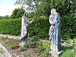
Figure group of Christ's farewell to St. Maria ObjectID : 94030 |
opposite Pottschacher Str. 48 KG location : Pottschach |
Holiday group at the junction Pottschacherstraße to the 18th century cemetery, restored in 2017 |
ObjectID : 94030 Status: § 2a Status of the BDA list: 2020-02-29 Name: Figure group Christ's farewell to St. Maria GstNr .: 1008/2 |
|
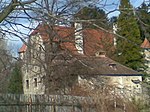
Pottschach Castle (Gut Pottschach) ObjectID : 33200 |
Pottschacher Str. 68, 70 KG location : Pottschach |
ObjectID : 33200 Status : Notification Status of the BDA list: 2020-02-29 Name: Schloss Pottschach (Gut Pottschach) GstNr .: .21; .22; 147/1; 149 Pottschach Castle |
|

|
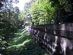
Part of the 1st Vienna Mountain Spring Pipeline ObjectID : 129160 |
Location see description KG: Pottschach |
For the I. HQL see the entry in the KG Rohrbach am Steinfelde In Pottschach, apart from the aqueduct 10a ( see there ), there is a canal bridge over the Saubach ( location ) and the entry tower 11 ( location ). |
ObjektID : 129160 Status : Notification Status of the BDA list: 2020-02-29 Name: Part of the 1st Vienna High Spring Pipeline GstNr .: 1122/1; 1122/2; 1113 I. Vienna high spring water pipeline |
|
Part of the 1st Vienna High Spring Pipeline, Aqueduct 10a ObjectID : 129162 |
Location KG: Pottschach |
For I. HQL see the entry in the KG Rohrbach am Steinfelde |
ObjektID : 129162 Status : Notification Status of the BDA list: 2020-02-29 Name: Part of the 1st Vienna High Spring Pipeline, Aqueduct 10a GstNr .: 1126 I. Vienna High Spring Pipeline |

|
Part of the 1st Vienna High Spring Pipeline, Aqueduct 10a ObjectID : 129163 |
KG location : Putzmannsdorf |
For I. HQL see the entry in the KG Rohrbach am Steinfelde |
ObjektID : 129163 Status : Notification Status of the BDA list: 2020-02-29 Name: Part of the 1st Viennese spring water pipeline, Aqueduct 10a GstNr .: 135 I. Vienna high spring water pipeline |

|
Part of the 1st Vienna Mountain Spring Pipeline ObjectID : 129161 |
at Lieslinger Weg 5 KG location : Putzmannsdorf |
For the I. HQL see the entry in the KG Rohrbach am Steinfelde In Putzmannsdorf is the entrance tower 10. |
ObjektID : 129161 Status : Notification Status of the BDA list: 2020-02-29 Name: Part of the 1st Vienna High Spring Pipeline GstNr .: 139/5; .23 I. Vienna high spring water pipeline |
Web links
Commons : Listed objects in Ternitz - collection of pictures, videos and audio files
Individual evidence
- ↑ a b Lower Austria - immovable and archaeological monuments under monument protection. (PDF), ( CSV ). Federal Monuments Office , as of February 14, 2020.
- ^ Entry on “Herz-Jesu-Kirche Ternitz” on the website of architekturlandschaft.niederösterreich
- ^ Entry on "Stadthalle Ternitz" on the website of architekturlandschaft.niederösterreich
- ^ Georg Clam Martinic : Burgen und Schlösser in Österreich, Landesverlag Linz, 1991, p. 195
- ↑ § 2a Monument Protection Act in the legal information system of the Republic of Austria .
