Luka (Sali)
| Luka (Sali) | ||
|
|
||
| Basic data | ||
|---|---|---|
| State : |
|
|
| County : |
|
|
| Island : | Dugi Otok | |
| Municipality : | Sali | |
| Height : | 126 m. i. J. | |
| Residents : | 36 (2011) | |
| Telephone code : | (+385) 023 | |
| Postal code : | 23285 | |
| License plate : | ZD | |
| Others | ||
| Patron saint : | St. Stefan | |
| City Festival : | 2nd and 3rd August | |
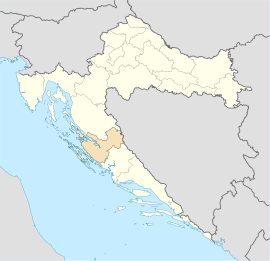
Luka is a village on the island of Dugi Otok , Croatia .
Location and inhabitants
Luka is located in the middle of Dugi Otok in the deeply cut Zlatna Vala bay , northeast of Žman . The largest hill of Dugi Otok, the Vela Straža, rises above the place from about 338 m height. The 123 inhabitants (2011) live from fishing, agriculture and tourism.
| Population development | |||||||||||||||
|---|---|---|---|---|---|---|---|---|---|---|---|---|---|---|---|
| 1857 | 1869 | 1880 | 1890 | 1900 | 1910 | 1921 | 1931 | 1948 | 1953 | 1961 | 1971 | 1981 | 1991 | 2001 | 2011 |
| 162 | 181 | 212 | 257 | 365 | 384 | 406 | 350 | 375 | 364 | 298 | 333 | 135 | 164 | 99 | 123 |
history
The settlement is first mentioned in 1365 in the form of “Vallis Sancti Stephani”. It was later called Sustipanjska Luka, whose name was shortened to today's Luka, which means port in German.
The parish church, dedicated to the first martyr of St. Stephen, was built in 1882 on the site of a medieval church.
There is a mud near Boka Bay that has completely natural, healing, relaxing properties.

