Brbinj
| Brbinj | ||
|
|
||
| Basic data | ||
|---|---|---|
| State : |
|
|
| County : |
|
|
| Island : | Dugi Otok | |
| Municipality : | Sali | |
| Residents : | 76 (2011) | |
| Telephone code : | (+385) 023 | |
| Postal code : | 23285 | |
| License plate : | ZD | |
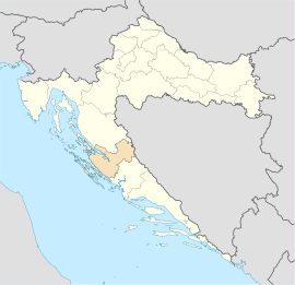
Brbinj is a village on the island of Dugi Otok in Croatia .
Location and inhabitants
Brbinj is located in the northeast of the island between the villages of Dragove and Savar . In 2011 the village had 76 inhabitants who live from simple agriculture, fishing, but most of them from tourism. Thanks to its bay, which is protected from the weather, it is the mooring point for the Supetar car ferry from Zadar , which moored three to four times a day.
| Population development | |||||||||||||||||
|---|---|---|---|---|---|---|---|---|---|---|---|---|---|---|---|---|---|
| 1608 | 1754 | 1857 | 1869 | 1880 | 1890 | 1900 | 1910 | 1921 | 1931 | 1948 | 1953 | 1961 | 1971 | 1981 | 1991 | 2001 | 2011 |
| 129 | 234 | 202 | 233 | 230 | 238 | 309 | 333 | 328 | 327 | 328 | 336 | 296 | 272 | 104 | 168 | 85 | 76 |
history
The name derives from the Latin Brninj verbena ( Verbena ab). Birbinium was the name of the first settlement. The parish of Sveti Kozma and Damjan in Brbinje was first mentioned in 1195 when Pope Celestine III. donated ten parishes to the St. Krsevan monastery in Zadar, including the parishes of St. Kozma and Damjan, at that time still under the name Berbinei and de Berbigno . At the beginning of the 12th century there were salt pans that belonged to the St. Krševan Monastery in Zadar . The parish church of Sveti Kozma and Damjan was built in the 14th century when the area was part of the Republic of Venice . Soppe Castle from the 16th century is still in ruins. Brbinj had 129 inhabitants in 1608.
In the period after the Second World War, there was a great emigration from Brbinj. From the 1970s, most residents moved to America and Australia.

