
Mühlenbach (Schwalm)
| Mühlenbach | ||
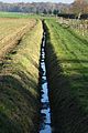
 The mouth of the Mühlenbach (left) into the Schwalm |
||
| Data | ||
| Water code | EN : 2844 | |
| location | District of Heinsberg , North Rhine-Westphalia ( Germany ) | |
| River system | Rhine | |
| Drain over | Schwalm → Maas → Hollands Diep → North Sea | |
| River basin district | Meuse | |
| source | in Mönchengladbach - Herrath 51 ° 6 ′ 16 ″ N , 6 ° 21 ′ 40 ″ E |
|
| Source height | 77 m above sea level NHN | |
| muzzle | at the Molzmühle von Rickelrath in the Schwalm Coordinates: 51 ° 9 '45 " N , 6 ° 16' 30" E 51 ° 9 '45 " N , 6 ° 16' 30" E |
|
| Mouth height | approx. 53 m above sea level NHN | |
| Height difference | approx. 24 m | |
| Bottom slope | approx. 1.8 ‰ | |
| length | 13.2 km | |
| Catchment area | 26.105 km² | |
The Mühlenbach is a 13.2 km long, southeast and orographically right tributary of the Schwalm in the North Rhine-Westphalian district of Heinsberg , in the administrative district of Cologne .
The care and maintenance of the Mühlenbach is the responsibility of the Schwalm Association, which is based in Brüggen .
geography
course
The Mühlenbach begins in the center of Herrath , a district of Mönchengladbach . Its source is about 77 m above sea level. NN . In its catchment area are the localities of Erkelenz - Mennekrath , the districts of Mönchengladbachs Baum , Bucholz, Genholland , Genhausen , Herrath, Hilderath , Merreter , Knoor, Sittard , Schriefers and Woof and the Wegberg districts of Ellinghoven , Gripekoven , Kipshoven , Mehlbusch and parts of Beeck and Beeckerheide . Coming from the direction of Buchholz, the Mühlenbach crosses under the B 57 and then runs northeast past the locality of Kipshoven. On the way to Merreter, the Mühlenbach takes the Ahlsbruchgraben and a little later the Sittardgraben into its structure. Past Gripekoven in Mönchengladbach- Gatzweiler the pond of the Vollmühle flows through. A total of five mill ponds are passed on the way before the Mühlenbach flows into the Schwalm Maas tributary coming from the south at Rickelrather Molzmühle at a height of around 53 m . The Mühlenbach forms the border between the town of Mönchengladbach and the Heinsberg district between Kipshoven and the Holtmühle .
Catchment area and tributaries
The catchment area of the Mühlenbach is 26.105 km² . Its tributaries include with orographic allocation (l = left-hand side, r = right-hand side) , length of water (viewed downstream) :
- Unnamed watercourse from Buchholz (r; approx. 1 km)
- Ahlsbruchgraben (r; 2 km)
- Sittardgraben (r; 2.6 km)
- Bachmannsgraben (l; 1.4 km)
Mills
Mühlen am Mühlenbach are or were:
- Vollmühle in Rheindahlen - Gatzweiler
- Holtmühle in Wegberg- Holtmühle
- Buschmühle in Wegberg- Busch
- Meismühle in Wegberg-Busch
- Schrofmühle (museum) in Wegberg- Rickelrath
- Molzmühle in Wegberg-Rickelrath
history
In earlier times the Mühlenbach was the lifeline of the medieval Gripekoven Castle and an important, well- watered stream that supplied numerous mills with water . Today the stream is mainly used for surface drainage . The Mühlenbach was also called Alsbach or Gripekovener Bach. While in the past the Mühlenbach began its existence through natural springs in the area of Gripekoven, nowadays considerable amounts of water are pumped in via pipelines . These swamps replace the water lost through lignite mining .
Fish pass
The Schwalmverband is building a fish pass at the Molzmühle in Rickelrath. According to the press release on March 2, 2012. The aim is to create a natural connection between the Mühlenbach and the Schwalm, so that fish and other aquatic organisms can find a barrier-free route through Schwalm and Mühlenbach. It is hoped that the Schwalm and its tributaries will once again become a habitat for original fish species such as eel, barbel , chub , gudgeon and perch. The system has now been completed.
gallery
The bush mill with pond at the mill stream
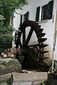
The Schrofmühle water wheel, now a museum

Roe deer also find a place on the Mühlenbach

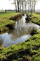
Meandering brook near the Molzmühle
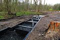
New fish pass between Schwalm and Mühlenbach

Beginning of the Mühlenbach fish pass

Carving at the Mühlenbach

Information board at Mühlenbach and Schwalm
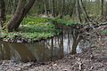
Wet habitat near the town of Herrath
The Mühlenbach as an open stream
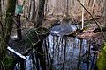
Level measurement on the Mühlenbach
The Mühlenbach as a natural stream

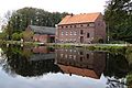
The Vollmühle am Mühlenbach in Gatzweiler
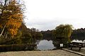
The Mühlenbach flows through the Holtmühle pond

The water wheel of the Holtmühle
Information board in the nature reserve


literature
- Hans Vogt: Lower Rhine water mill guide 2nd edition. Verein Niederrhein, Krefeld 1998, ISBN 3-00-002906-0 , pp. 426-434.
- Toni Mennen: The medieval Gripekoven Castle and the Dalen Lordship , Part 2, 1993, pp. 120–121
- Horst Jung u. Helmut Elsner: The Schwalm - In the valley of the mills , pp. 70–79
- Wegberg cultural guide, p. 103
Web links
- Nature reserve “Mühlenbachtal” in the specialist information system of the State Office for Nature, Environment and Consumer Protection in North Rhine-Westphalia
- Wonderful water views on the Mühlenbach, on rp-online.de
Individual evidence
- ↑ a b Topographical Information Management, Cologne District Government, Department GEObasis NRW ( Notes )
- ↑ a b German basic map 1: 5000
- ↑ a b c d e Water directory of the State Office for Nature, Environment and Consumer Protection NRW 2010 (XLS; 4.67 MB) ( Notes )
- ↑ Our tasks , on schwalmverband.de
- ↑ Wassermühle, Buschmühle (serial number 30), in monuments in the city of Wegberg on limburg-bernd.de
- ↑ Watermill Schrofmühle (serial number 8), in monuments in the town of Wegberg on limburg-bernd.de
- ↑ Courtyard with watermill Molzmühle (serial number 92), in monuments in the city of Wegberg on limburg-bernd.de
- ↑ Fish ladder for the Schwalm , from March 2, 2012, on rp-online.de