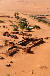
Madama
Madama (Arabic Bir Achmar or Bir el Ahmar ["The Red Fountain"]) is a military settlement in the central Sahara, in the northeastern Niger River in the municipality of Djado , about 100 kilometers from the border with Libya .
Madama / Bir el Ahmar as a station on the Bornu Strait
The watering hole of Madama was an important station of the old Bornustraße , in their most difficult because settlement empty central section between the oases Tegerhi the north (about 305 km north of Madama) and Anney , some 320 kilometers south of Madama. A permanent settlement did not exist here until well into the 20th century, because the capacity of the well would not have been sufficient for irrigation and the laterite soil near Madama is sterile. The Bir el Ahmar, like mostly the entire central and southern Bornus Strait between al-Qatrun and Bilma , has been under the Tubu's sphere of influence for centuries . The Tuareg ruled area begins a few hundred kilometers to the west.
Development of military posts and settlement
The current location is on the site of a former military post of the French colonial empire , which was established in September 1930, and has essentially consisted of a base of Niger's armed forces since Niger gained independence in 1960 . In Madama and from Madama, Nigerien authorities control cross-border traffic to and from Al Qatrun (Libya).
Renewed French military presence since 2014
The French army has been using Madama again since 2014, now as a base for Operation Barkhane , which is directed against al-Qaeda activities in the Maghreb . In the course of this operation, the laterite airstrip a few kilometers northeast of Madama was extended from 1,300 to 1,800 meters and converted into a small military airfield. Another purpose of the French presence in Madama is to observe the migration movements from West Africa to Europe, most of which cross the Sahara on this route and thus follow the historic Bornus Strait.
Position map
Note: The labels on the position map can be clicked and lead to the associated Wikipedia articles.
Location of Madama in northeast Niger |
Web links
Individual evidence
- ↑ Erwin Lindner: Bir Muschru . Vienna 1980, p. 3f.
- ↑ Edmond Séré de Rivières: Histoire du Niger . Berger-Levrault, Paris 1965, p. 232.
- ↑ Olivier Fourt: Au Niger, Fort Madama, l'avant poste de l'opération Barkhane. RFI , January 4, 2015, accessed January 9, 2015 (French).
Coordinates: 21 ° 57 ' N , 13 ° 39' E


