Marienviertel (Oberhausen)
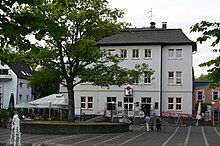
The Marienviertel is a district of Oberhausen in the district of Alt-Oberhausen . The name is derived from the Marienkirche built in 1857 . The statistical district "Marienkirche" has an area of 3.67 km 2 5431 inhabitants.
The core area of the Marienviertel is bordered by railway lines to the west and north, by the B 223 (Mülheimer Straße) to the east and by Ebertstraße to the south. The urban settlement of the original heathland began in the second half of the 19th century.
At times the city planners pursued the goal of concentrating the Neumarkt - today's Ebertplatz - the center of the still young city and creating a counterweight to the old market, which is establishing itself as a business center. However, this plan failed due to local economic interests - also in a renewed attempt at the beginning of the 20th century to give the town hall district, which is now grouped around the Grillopark, more weight to the north through further public institutions.
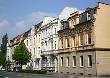
On the other hand, the planning efforts to create a spacious, upscale residential area on the other side of Mülheimer Strasse in the east of the Marienkirche, which was to act as a kind of "buffer" between the city center and the workers' housing estates further east, were more successful and sustainable. Alleys , some with central promenades, open development and illustrious names such as Bismarck-, Goethe- and Schillerstraße signaled a “solid, middle-class residential area” which, along with the town hall district and the Grafenbusch settlement, was one of the best addresses in Alt-Oberhausen. As a counterpart to the Marienkirche, the Luther Church, consecrated in 1899, was built in the center of this quarter.
The “Bismarckviertel”, which is now officially known as “Marienviertel-Ost”, still has a relatively high proportion of representative townhouses for Oberhausen, even if more modern, more urban development took hold, especially along Mülheimer Straße after the Second World War. More recently, the term “Marienviertel” has found a much wider interpretation than at the time of its origins in the socio-spatial division of the urban area. The Marienviertel (West) quarter in the Oberhausen-Mitte / Styrum social area also includes the town hall district to the south, the “Am Kaisergarten” industrial and technology park north of the Duisburg – Dortmund railway line, and the Kaisergarten recreational area itself; while the Marienviertel (Ost) quarter in the Oberhausen-Ost social area is part of the “Am Technologiezentrum” industrial estate, which is also north of the railway line. The Marienviertel, which has been upgraded in this sense as a link between the old city center and the new center , is still to be seen as a preferred quarter, which also has numerous cultural and infrastructural facilities, including a grammar school and a comprehensive school, two hospitals, city hall and city theater as well as sights such as the castle Oberhausen or the Gutehoffnungshütte restaurant .
See also
Individual evidence
- ↑ Area and population according to statistical districts 2013 , in: Statistisches Jahrbuch der Stadt Oberhausen , year 2014, p. 31 ( http://www.oberhausen.de/de/index/rathaus/verwaltung/familie-bildung-soziales/statistik- and-elections / statistics / veroeffublikungen.php )
- ^ Heinz Reif: The belated city. Industrialization, urban space and politics in Oberhausen 1846 - 1929 . Textband, Cologne 1993, esp.p. 404.
- ^ Heinz Reif: The belated city. Industrialization, urban space and politics in Oberhausen 1846 - 1929 . Textband, Cologne 1993, p. 202.
- ↑ See the Oberhausen social space map ( City of Oberhausen: Nah dran - social space talks )
Coordinates: 51 ° 28 ′ 40 " N , 6 ° 51 ′ 47" E

