Mensfeld head
| Mensfeld head | ||
|---|---|---|
|
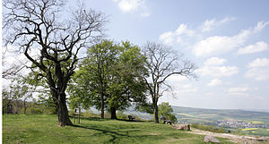
View over the plateau of the Mensfelder Kopf |
||
| height | 313.7 m above sea level NHN | |
| location | at Mensfelden ; District of Limburg-Weilburg , Hesse ( Germany ) | |
| Mountains | Taunus ( Limburg Basin ) | |
| Dominance | 5.75 km → Karlskopf (325 m) | |
| Coordinates | 50 ° 20 '46 " N , 8 ° 5' 24" E | |
|
|
||
The Mensfelder Kopf near Mensfelden in the Hessian district Limburg-Weilburg is 313.7 m above sea level. NHN high elevation on the edge of the Kirberg hill country to the transition into the Limburg basin .
geography
location
The Mensfelder Kopf lies in the Kirberg hill country. It rises directly to the west of Mensfelden, a district of the municipality of Hünstelden , and south of the Limburg district of Linter . To the north, the landscape leads along the Kasselbach into the valley of the Lahn near Limburg. To the south it falls into the valley of the Mühlbach (Herbach) , which flows into the Aar, which flows southwest to west of the elevation ; on this river lies at the southwest foot of the elevation Niederneisen . About 7.5 km southwest, beyond the Aartal, is the 419.7 m high Ergenstein .
Natural allocation
The Mensfelder head belongs to the physiographic feature unit group Gießen-Koblenzer Lahntal (no. 31) in the main unit Limburger Basin (311) and in the subunit of South Limburg Beck hills (311.2) for the natural environment Kirberger hills (311.20). To the north, the landscape drops into the natural area of Linter-Platte (311.10), part of the Inner Limburg Basin sub-unit (311.1) .
Protected areas
The Mensfelder Kopf is a quartzite dome overgrown with heather and only partially forested . In 1998, small parts of the survey were declared a nature reserve Mensfelder Kopf ( CDDA no. 318779; 2003; 7.17 hectares in size), particularly because of the wild growing heather . The fauna-flora-habitat area Mensfelder Kopf (FFH no. 5614-302; 35.11 ha) is located on it. Furthermore, the elevation with its surrounding flora forms a refuge for threatened bird species. This is why parts of the Feldflur bird sanctuary near Limburg (VSG no. 5614-401; 7.1576 km² ) are located on the lower areas of the north-northwest slope .
Sports and hiking
South of the summit region of the Mensfelder Kopf is a sports center, where the Mensfelder Kopf mountain gymnastics festival has been held annually since 1896 . It is the sports facility of the Mensfelden gymnastics and sports club. The hiking trail Hessenweg 9 leads over the elevation .
Opportunities for viewing
The Mensfelder Kopf is particularly known for its view over the Limburg Basin. With good visibility you can see more than 50 villages from its summit region. Then the view extends to the west to the foothills of the western Hintertaunus , to the northwest over the Lahn valley to the Westerwald with the Montabaurer Höhe ( 545.2 m ) in the Niederwesterwald , to the north over the Limburg basin to the Oberwesterwald and the Hohen Westerwald , further northeast the Dünsberg ( 497.7 m ) can be recognized and to the east and south into the Taunus over the Goldenen Grund and Idsteiner Senke with the Eastern Hintertaunus and the Hochtaunus with the Großer Feldberg (approx. 879 m ) in the Taunushauptkamm .
See also
Individual evidence
- ↑ a b c Map services of the Federal Agency for Nature Conservation ( information )
- ↑ Heinrich Müller-Miny, Martin Bürgener: Geographical land survey: The natural spatial units on sheet 138 Koblenz. Federal Institute for Regional Studies, Bad Godesberg 1971. → Online map (PDF; 5.7 MB)


