Mulkwitz
|
Mulkwitz
Mułkecy Community loop
Coordinates: 51 ° 30 ′ 40 ″ N , 14 ° 29 ′ 55 ″ E
|
|
|---|---|
| Height : | 121 m above sea level NN |
| Area : | 7.36 km² |
| Residents : | 252 (Dec. 31, 2009) |
| Population density : | 34 inhabitants / km² |
| Incorporation : | January 1, 1996 |
| Postal code : | 02959 |
| Area code : | 035773 |
|
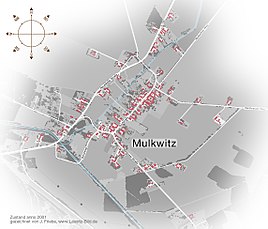
Local map
|
|
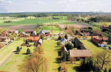
Mulkwitz , Sorbian Mułkecy is a municipality loop in the Oberlausitz ( axes ). The formerly independent municipality in the Sorbian settlement area joined on January 1, 1996 Loop.
In the Schleifer dialect the place is called Mułkoce . Unlike the Upper Sorbian name, this name is not official.
geography
Mulkwitz is located in the far northwest of the district of Görlitz on the state road 130 ( Burgneudorf –Schleife– Groß Düben ). To the northeast lies Rhone , in the east of the former zoo area (municipality Trebendorf ), it close Mühlrose and open pit Nochten in the southeast and New Town in the southwest on.
The village center on Dorfstraße runs in the form of a street village parallel to the Struga , which, coming from Rohne, continues its way towards Neustadt towards the Spree. To the west of the town center, the Breite Graben from Mühlrose flows into the Struga. Heavily filled by pit water, it has more water at this point than the Struga itself.
history

Local history
Mulkwitz was probably founded by Slavic settlers in the 12th century after the area was deserted for centuries.
After the von Köckritz family , who were among the richest noble families in Lusatia in the 14th and 15th centuries, disappeared from Runde around 1430, the parish Runde , to which Mulkwitz belonged throughout its history, was divided into three manors. Presumably Mulkwitz together with Mühlrose and Tzschelln paid interest to the gentlemen von Pannewitz . Fabian von Schoenaich , who expanded the Muskau rulership between 1551 and 1573, also acquired the lands around Mulkwitz, Mühlrose and Tzschelln from the Pannewitzers, so that the Muskau rulership extended to the west as far as the Spree . The rule was to play a major role in the development of the village over the next 400 years. Although no farmworks were built in the village, the extensive forest areas were of economic importance.
When the von Schönaich family died out, the Muskau rule fell to the crown. The German Emperor and King of Bohemia Rudolf II sold the rule to Wilhelm Burggraf von Dohna in 1597. In this purchase agreement, Mulkwitz - like the neighboring village of Rohne - is first mentioned in a document as "the village of Mulckwiz with its accessories".
By marriage, Curt Reinicke von Callenberg came into the possession of the Muskau rulership in 1644. The income from the class rule was extremely low due to the Thirty Years' War and its sometimes devastating effects. He and later his son and successor, Curt Reinicke II. Von Callenberg , therefore endeavored to renovate the manorial property and to continue it profitably. Curt Reinicke II was not very reluctant to choose the means. For example, between 1678 and 1690 he quarreled with farmers from the Schleifer parish about unpaid labor. In the beginning there were only farmers from Runde, but in 1686 there were also arguments with those from Mulkwitz, Mühlrose and Rohne. Determined to break the peasant resistance, he used his lordly possibilities. As a result, several farmers fled to the neighboring rule Hoyerswerda or Lieskau in Lower Lusatia .
The school inschleife founded in 1730 for the entire parish was followed by a school in Mühlrose in 1770, to whose school community Mulkwitz also belonged. Mulkwitz was only to have its own school in 1893.
In order to improve agricultural yields after the drought years of 1770/1771, Count Hermann von Callenberg had drainage ditches drawn in several communities after taking office in 1774, including Mulkwitz.
After the Kingdom of Saxony fought on the French side in the Napoleonic Wars , it had to cede over half of its land area to Prussia in 1815. In this way Mulkwitz came to the province of Silesia and was assigned to the newly founded district of Rothenburg (Ob. Laus.) .
A few years before Rohne, Mulkwitz got a school in 1893. After its closure in the 1970s, the children went to primary school in Rohne; Loop was already a middle school location before .
After the Second World War, the part of the Prussian Upper Lusatia located west of the Lusatian Neisse , and thus also Mulkwitz, was reassigned to the state of Saxony. Since the administrative reform of 1952 , the village has belonged to the Weißwasser district in the Cottbus district .
Opencast mining as the main employer in the second half of the 20th century also left its mark on Mulkwitz. North West of the town was built up in 1974 by Abhaldung of digestion spoil the pit Nochten the 420-hectare outdoor dump Mulkwitz that rises up to 34 meters above the surrounding terrain.
In GDR times there was the so-called toy booth near the cemetery, where plastic items were made. Where the Nochten open-cast mine used to be located on Neustädter Strasse, Reinert Logistics is now a global player with over a thousand jobs.
The 2013/2014 approval of the application by Vattenfall Europe Mining AG for the continuation of the Nochten opencast mine to the northwest would have meant, among other things, the complete relocation of the Rohne and Mulkwitz locations and their over-dredging in the 2020s. The Lieskauer Weg north of the Schleifer town center was planned as a resettlement location for the village community. However, on March 30, 2017, the new owner LEAG announced with the district concept that it would forego the expansion of the Nochten open-cast mine.
Population development
| year | Residents |
|---|---|
| 1782 | 131 |
| 1825 | 186 |
| 1863 | 224 |
| 1871 | 255 |
| 1885 | 278 |
| 1905 | 325 |
| 1910 | 337 |
| 1925 | 367 |
| 1933 | 341 |
| 1939 | 352 |
| 1946 | 380 |
| 1950 | 383 |
| 1964 | 368 |
| 1971 | 340 |
| 1990 | 257 |
| 1996 | 264 |
| 2002 | 277 |
| 2006 | 265 |
| 2009 | 252 |
From the year 1630, the Thirty Years War (1618–1648) lasted twelve years, a population of 14 possessed men , 3 gardeners and 1 housekeeper is reported . Seventeen years later, shortly before the end of the war, the village has a wild gardener and a housekeeper. In 1699 the gardener position was occupied again, the cottage industry position was no longer occupied. From the year 1777, the consequences of the Seven Years' War (1756–1763) had not yet been completely overcome, a desolate economy is transmitted. The rest of the population information is identical to that of 1699: 14 possessed men and 3 gardeners. By 1782 the number of possessed men had reduced to 12.
In 1782 131 inhabitants lived in the 15 taverns. This population rose almost continuously to over 380 until the middle of the 20th century, but then fell again. Between 1990 and 2009, the number of residents in Mulkwitz fluctuated between 250 and 280.
Mulkwitz originally had a Sorbian population. In 1863, according to official data, 201 of the 224 inhabitants were Sorbs , around 20 years later the Sorbian population was even 98.6%. At that time Muka determined in Mulkwitz for his statistics of the Sorbs in Upper Lusatia 278 Sorbs and 4 Germans. In 1956 Ernst Tschernik still had a Sorbian-speaking population of 88.5%, making it the highest in the Schleifer parish. Since then, the number of Sorbian speakers in Mulkwitz has declined.
Place name
The origin of the place name can no longer be interpreted with certainty. Place name researchers assume, however, that it could be the derivation of a person's name. The German name Mulkwitz, derived from the Sorbian name Mułkecy, would therefore mean 'People of a Mułk'.
Sources and further reading
literature
- From the Muskauer Heide to the Rotstein. Home book of the Lower Silesian Upper Lusatia District . Lusatia Verlag, Bautzen 2006, ISBN 978-3-929091-96-0 , p. 225 f .
- Hermann Graf von Arnim, Willi A. Boelcke: Muskau. Jurisdiction between the Spree and the Neisse . Ullstein publishing house, Frankfurt / M, Berlin, Vienna 1978.
Footnotes
- ^ StBA: Changes in the municipalities in Germany, see 1996
- ↑ Quoted from Paul Kühnel: The Slavic place and field names of Upper Lusatia . Central antiquariat of the German Democratic Republic, Leipzig 1982, p. 79 (photomechanical reprint of the original edition (1891–1899)).
- ^ Tilo Berger: Mulkwitz, Rohne and Schleifes south are not being excavated. (No longer available online.) Sächsische Zeitung, March 30, 2017, archived from the original on March 31, 2017 ; accessed on March 30, 2017 . Info: The archive link was inserted automatically and has not yet been checked. Please check the original and archive link according to the instructions and then remove this notice.
- ↑ a b von Arnim, Boelcke: Muskau. Page 602
- ^ Mulkwitz in the Digital Historical Directory of Saxony
- ↑ Joachim Mühle (Ed.): From the Muskauer Heide to the Rotstein. Home book of the Lower Silesian Upper Lusatia District. Lusatia Verlag, Bautzen 2006, p. 225 f .
- ↑ Municipal directory Germany 1900. Retrieved on June 24, 2008 .
- ^ Michael Rademacher: German administrative history from the unification of the empire in 1871 to the reunification in 1990. Rothenburg district (Upper Lusatia). (Online material for the dissertation, Osnabrück 2006).
- ↑ Saxony regional register. Retrieved June 24, 2008 .
- ↑ Residents' registration office loop ( Memento of the original dated June 7, 2015 in the Internet Archive ) Info: The archive link was inserted automatically and has not yet been checked. Please check the original and archive link according to the instructions and then remove this notice.
- ^ Ludwig Elle: Language policy in the Lausitz . Domowina-Verlag, Bautzen 1995, p. 255 .
Web links
- Information about Mulkwitz on the website of the municipality of Runde
- Umsiedler-Schleife.de - Citizens' initiative of the residents of Rohne and Mulkwitz affected by the Nochten opencast mine


