Municipio Coripata
| Municipio Coripata | ||
|---|---|---|
| Basic data
|
||
| Population (state) - population density |
17,586 inhabitants (2012 census) 17 inhabitants / km² |
|
| Post Code | 02-1402 | |
| Telephone code | (+591) | |
| surface | 1,055 km² | |
| height | 1500 m | |
| Coordinates | 16 ° 10 ′ S , 67 ° 35 ′ W | |
|
|
||
| politics
|
||
| Department | La Paz | |
| province | Nor Yungas Province | |
| Central place | Coripata | |
| climate | ||
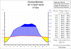
 Coroico climate diagram |
||
The Municipio Coripata is a district in the La Paz department in the South American Andean state of Bolivia .
Location in the vicinity
The municipality Coripata is one of two municipalities in the province of Nor Yungas and is located in the eastern part of the province. It is bordered to the northwest and west by the Municipio Coroico , to the south and east by the province of Sud Yungas , and to the north by the province of Caranavi .
The municipality has 50 localities ( localidades ). The central place of the municipality is the village Coripata with 1,238 inhabitants ( 2012 census ) in the southern part of the district.
geography
The municipality of Coripata is located in the transition area between the Altiplano and the Cordillera Real in the west and the foothills of the Amazon lowlands in the east.
The annual precipitation here in the subtropical Yungas is 1100 mm (see Coroico climate diagram) and has a clear dry season from May to August and a rainy season from December to February. The monthly average temperatures fluctuate only slightly between 20 ° C and 25 ° C, during the day it is warm in summer and pleasantly cool at night.
population
The population of the Municipio Coripata has increased by more than two thirds in the past two decades:
| year | Residents | source |
|---|---|---|
| 1992 | 10 276 | census |
| 2001 | 11 444 | census |
| 2012 | 17 586 | census |
In the last census of 2012 the municipality had a population density of 16.7 inhabitants / km², the life expectancy of newborns in 2001 was 60.4 years, the infant mortality rate was from 8.0 percent (1992) to 7.2 percent in 2001 decreased slightly.
The literacy rate among those over 19 is 82.5 percent, 90.0 percent for men and 74.7 percent for women (2001) .
90.5 percent of the population speak Spanish , 72.3 percent speak Aymara , and 0.6 percent speak Quechua . (2001)
32.6 percent of the population have no access to electricity , 75.9 percent live without sanitary facilities (2001) .
83.2 percent of the total of 3,036 households have a radio, 37.5 percent a television, 12.1 percent a bicycle, 12.3 percent a motorcycle, 3.5 percent a car, 9.4 percent a refrigerator and 0.4 percent Percent a phone. (2001)
politics
Results of the elections for the municipal council ( concejales del municipio ) in the regional elections on April 4, 2010:
| Eligible voters | be right | valid | MAS -IPSP | MPS | ASP | ||
|---|---|---|---|---|---|---|---|
| 9,395 | 8,032 | 5,513 | 2,611 | 2.017 | 885 | ||
| 100% | 68.6% | 47.4% | 36.6% | 16.1% |
structure
The municipality was subdivided in the last census of 2012 in the following three cantons ( cantones ):
- 02-1402-01 Canton Coripata - 16 villages - 7,461 inhabitants ( 2001: 5,534 inhabitants )
- 02-1402-02 Canton Milluhuaya - 10 towns - 2,109 inhabitants ( 2001: 989 inhabitants )
- 02-1402-03 Canton Arapata - 24 villages - 8,016 inhabitants ( 2001: 4,921 inhabitants )
Localities in the municipality of Coripata
- Coripata Canton
- Coripata 1238 pop - Nogalani 748 pop - Chillamani 601 pop - Auquisamaña 575 pop - Coscoma 565 pop - Machacamarca 490 pop - Marquirivi 474 pop - Tabacal 445 pop - Pararani 383 pop - Huayrapata 310 pop - Santa Bárbara Pop 292 - Anacuri Pop 246 - Umamarca Pop 147
- Milluhuaya Canton
- Santa Gertrudis 529 pop - Los Anguias 472 pop - Milluhuaya 424 pop .
- Canton of Arapata
- Arapata 1984 pop - Trinidad Pampa 1958 pop - Santa Rosa de Lima 995 pop - San José de Pery 989 pop - San Agustín 778 pop - Dorado Grande 464 pop - Chacón 439 pop - Choro Grande 424 pop - San Felix 367 pop.
Individual evidence
- ^ INE - Instituto Nacional de Estadística Bolivia 1992
- ^ INE - Instituto Nacional de Estadística Bolivia 2001
- ↑ INE - Instituto Nacional de Estadística Bolivia 2012 ( Memento of the original from March 4, 2016 in the Internet Archive ) Info: The archive link was inserted automatically and has not yet been checked. Please check the original and archive link according to the instructions and then remove this notice.
- ↑ Acta de computo Nacional Electoral Departamentales, Municipales y Regional 2010
Web links
- Relief map of the Chulumani region 1: 100,000 (PDF; 13.7 MB)
- Relief map of the La Paz region 1: 250: 000 (PDF; 11.3 MB)
- Municipio Coripata - General Maps No. 21401
- Municipio Coripata - detailed map and population data (PDF; 594 kB) ( Spanish )
- Departamento La Paz - social data of the municipalities (PDF; 11.63 MB) ( Spanish )
