Municipio Villa Hidalgo (Jalisco)
| Villa Hidalgo | ||
|---|---|---|

|
||
| Symbols | ||
|
||
| Basic data | ||
| Country | Mexico | |
| State | Jalisco | |
| Seat | Villa Hidalgo | |
| surface | 454.1 km² | |
| Residents | 18,711 (2010) | |
| density | 41.2 inhabitants per km² | |
| founding | before 1869 | |
| Website | villahidalgo.gob.mx/ | |
| INEGI no. | 14116 | |
| politics | ||
| Presidente municipal | Pablo Rodríguez Avelar | |
Coordinates: 21 ° 40 ′ N , 102 ° 36 ′ W
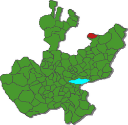
Villa Hidalgo , until 1869 Paso de Sotos , is a municipality in the Mexican state of Jalisco in the Altos Norte region . The municipality had 18,711 inhabitants at the 2010 census; the area of the municipality is 454.1 km².
Largest place in the municipality and administrative seat is the eponymous Villa Hidalgo , another place with at least 1000 inhabitants exists with Tepusco . The municipality comprises a total of 41 localities.
The Municipio Villa Hidalgo borders the Municipio Teocaltiche and the states of Aguascalientes and Zacatecas .
The municipality is mostly on a plain at between 1800 m and 2000 m above sea level, the highest point of the municipality is at an altitude of 2600 m . Around a third of the community area is forested, around a quarter each is used agricultural area or pasture area.
Web links
- Enciclopedia de los Municipios y Delegaciones de México: Municipio Villa Hidalgo (Spanish)
- INEGI : Datos Geográficos: Municipio Villa Hidalgo (Spanish; PDF)
- jalisco.gob.mx: Villa Hidalgo (Spanish)

