Němčice (Ivančice)
| Němčice | ||||
|---|---|---|---|---|
|
||||
| Basic data | ||||
| State : |
|
|||
| Region : | Jihomoravský kraj | |||
| District : | Brno-venkov | |||
| Municipality : | Ivančice | |||
| Area : | 257 ha | |||
| Geographic location : | 49 ° 6 ' N , 16 ° 22' E | |||
| Height: | 208 m nm | |||
| Residents : | 775 (2011) | |||
| Postal code : | 664 91 | |||
| License plate : | B. | |||
| traffic | ||||
| Street: | Ivančice - Moravský Krumlov | |||
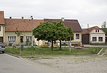
Němčice (German Niemtschitz ) is a district of the city of Ivančice in the Czech Republic . It is located one kilometer southwest of the city center of Ivančice and belongs to the Okres Brno-venkov in South Moravia .
geography
Němčice is located on the right bank of the Jihlava - across from the confluence of the Oslava - in the Boskovická brázda ( Boskowitz furrow ); east of the village the Rokytná flows into the Jihlava. In the east rises the Réna ( Reinberg , 319 m nm), southeast of the U Buku ( Buchenberg , 382 m nm). State road II / 152 between Ivančice and Dukovany runs through the village . The Krumlovský les ( Kromau Forest ) extends to the east and south . The railway line Hrušovany nad Jevišovkou – Brno runs through the forest area, the Němčice nad Jihlavou stop located there has been dismantled.
Neighboring towns are Ivančice in the north, Stříbský Mlýn and Moravské Bránice in the east, Nové Bránice , Trboušany and Maršovice in the southeast, Stavení, Hubertus and Vedrovice in the south, Budkovice and Alexovice in the southwest and Letkovice in the west.
history
The village in was first mentioned in documents 1355. Ludwig von Weimislitz left in 1359 his property in Weimislitz and Nemčić except Wittums his wife Elizabeth the Czesniek of Leipa on Castle Krumlov . Later the village was added to the Oslawan rule . Peter Ernst von Mollart sold Oslawan with all its accessories, including Niemczicz in 1712, to the Maria Saal Cistercian Abbey in Altbrünn. After their repeal in the course of the Josephine reforms , the Oslawan estates fell to the religious fund in 1782, which leased them to Johann Nepomuk von Scharff in 1789. In 1800 Scharff bought the rule.
In 1835 the village of Niemtschitz or Niemczyce , located in the Brno district on the trade route from Schwarzkirchen to Mährisch Budwitz , consisted of 78 houses in which 420 people lived. There was a brandy house and a mill with a stately tavern in the village. The parish was Eibenschitz . Until the middle of the 19th century, Niemtschitz remained subject to the allodial rule of Oslawan.
After the abolition of patrimonial formed Němčice / Niemtschitz 1849 a municipality in the judicial district Eibenschitz . From 1869 the village belonged to the Brno District ; at that time Němčice had 692 inhabitants and consisted of 87 houses. Between 1867 and 1870 the Vienna – Brno railway line was built through the Kromau Zoo; Two railway tunnels ( Buchenberg and Reinberg tunnels ) were built on the Buchenberg in the Budkowitz district . In 1900 there were 733 people in Němčice; In 1910 there were 836. In 1920 the municipality was assigned to the newly created Okres Brno-venkov . In the 1921 census, 900 people lived in the village's 182 houses, including 885 Czechs and 7 Germans. In 1930 Němčice had 1051 inhabitants and consisted of 213 houses. After the German occupation, the municipality of Němčice / Niemtschitz belonged to the Protectorate of Bohemia and Moravia from 1939 to 1945 . In 1948 Němčice was reclassified in the Okres Rosice. The incorporation after Ivančice took place in 1949. 1950 lived in Němčice 950 people. In the course of the territorial reform and the repeal of the Okres Rosice, the village came back to the Okres Brno-venkov on July 1, 1960. At the 2001 census there were 724 people living in Němčice's 248 houses. There is a primary school and a kindergarten in Němčice.
Local division
The district Němčice consists of the basic settlement units Němčice and Záhumenice. The district forms the cadastral district Němčice u Ivančic .
Attractions
- Chapel, in the village square
- Memorial stone for the fallen of the First World War, on the village square
- Wayside shrine, at the crossroads south of the village square
- Stone cross, at the junction north of the village square, created in 1887
literature
- Historický lexikon obcí České republiky 1869–2005 , part 1, p. 622
Individual evidence
- ↑ Katastrální území Němčice u Ivančic: podrobné informace , uir.cz
- ^ Gregor Wolny : The Margraviate of Moravia, presented topographically, statistically and historically . Volume II: Brno District, Division II, Brno 1837, p. 264
- ↑ Chytilův místopis ČSR, 2nd updated edition, 1929, p. 882 Neznašov - Němčovice
- ↑ Základní sídelní jednotky


