
Oberau (municipality of Schwarzenbach)
| Oberau ( Rotte ) | |||
|---|---|---|---|
|
|||
| Basic data | |||
| Pole. District , state | Wiener Neustadt-Land (WB), Lower Austria | ||
| Pole. local community | Schwarzenbach ( KG Schwarzenbach) | ||
| Locality | Schwarzenbach (absent-minded) | ||
| Coordinates | 47 ° 37 '54 " N , 16 ° 20' 1" E | ||
| height | 460 m above sea level A. | ||
| Post Code | 2803 | ||
| prefix | + 43/02645 | ||
| Statistical identification | |||
| Counting district / district | Schwarzenbach (32326 000) | ||
| Source: STAT : index of places ; BEV : GEONAM ; NÖGIS | |||

The Oberau is a group of the market town of Schwarzenbach in the district of Wiener Neustadt-Land in Lower Austria .
geography
Oberau is located in the corridor of the same name, on the eastern edge of the Bucklige Welt in the industrial district of Lower Austria . The place is west of the market Schwarzenbach at 460 m above sea level. A. , coming from Wiesmath on the Horaubach . The place Plettenhof of the community Wiesmath borders directly on Oberau.
Neighboring places:
| Haaghöfe ( Hochwolkersdorf (Dispersed) , Gem. Hochwolkersdorf) |
Schwarzenbach-Föhrensiedlung | |
|
Horau Hölle (Wiesmath community) |
.svg)
|
Schwarzenbach market |
| Nice |
history
Place name
The Oberau is one of the highest-lying floodplains in Schwarzenbach, which is probably what gave its name to the Rotte of the same name. An older spelling of the place name is Ober Aue . In the Josephinische Landesaufnahme the place is also called Dorf Oberau , also the spelling Ober-Au can be found.
Historical maps
- Schwarzenbach and his Rotten (recording sheets of the Josephinische Landesaufnahme and the Franzisco-Josephinische Landesaufnahme )

around 1780: Dorf Oberau on the map of the Josephinische Landesaufnahme (on the royal Hungarian border)
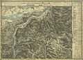
1880: Ober-Au (far right below) and north-western surroundings of Schwarzenbach


Web links
Individual evidence
- 32326 - Schwarzenbach. Community data, Statistics Austria .

Cadastral communities: Schwarzenbach
Locations: Schwarzenbach | Schwarzenbach (absent-minded)
Market place: Schwarzenbach Rotten: Eggenbuch | Essengraben | Hocheckgraben | Hochegg | Oberau | Beautiful | Schulau | Meets scattered houses: glass moat | Hackbichl | Königsbichl | Bike school pages | Schölderl | Schwarzenbach (absent-minded)
Counting district: Schwarzenbach