
Schwarzenbach (Lower Austria)
|
market community Schwarzenbach
|
||
|---|---|---|
| coat of arms | Austria map | |
 |
|
|
| Basic data | ||
| Country: | Austria | |
| State : | Lower Austria | |
| Political District : | Wiener Neustadt-Land | |
| License plate : | WB | |
| Surface: | 22.34 km² | |
| Coordinates : | 47 ° 38 ' N , 16 ° 21' E | |
| Height : | 383 m above sea level A. | |
| Residents : | 922 (January 1, 2020) | |
| Population density : | 41 inhabitants per km² | |
| Postcodes : | 2802, 2803 | |
| Area code : | 02645 | |
| Community code : | 3 23 26 | |
| NUTS region | AT122 | |
| Address of the municipal administration: |
Markt 4 2803 Schwarzenbach |
|
| Website: | ||
| politics | ||
| Mayor : | Bernd Rehberger ( SPÖ ) | |
|
Municipal Council : (Election year: 2020 ) (19 members) |
||
| Location of Schwarzenbach in the Wiener Neustadt-Land district | ||
  |
||

|
||
| Source: Municipal data from Statistics Austria | ||

Schwarzenbach is a market town with 922 inhabitants (as of January 1, 2020) in the Wiener Neustadt-Land district in Lower Austria .
geography
Schwarzenbach is located in the Bucklige Welt , in the industrial district of Lower Austria, about 20 kilometers south of Wiener Neustadt , right on the border with Burgenland . The market town extends to the southern end of the Rosaliengebirge and the eastern edge of the Bucklige Welt, which descends here towards the southeast towards the Mittelburgenland Bay , an area called the Landseer Berge .
The area of the market town covers 22.31 square kilometers. 48.22 percent of the area is forested.
Community structure
The only village is Schwarzenbach. The community consists of the Schwarzenbach cadastral community .
![]() Schwarzenbach
Schwarzenbach
Schwarzenbach (Scattered)
-
 Alm
Alm
-
-
Harrow book (R)
-
Essengraben (R)
-
Glasgraben (ZH)
-
Hackbichl (ZH)
-
Hocheckgraben (R)
-
Hochegg (R)
-
Königsbichl (ZH)
-
Oberau (R)
-
Bike School Pages (ZH)
-
Schölderl (ZH)
-
Nice (R)
-
Schulau R
-
Trift (R)
Neighboring communities
| Hochwolkersdorf |
Mattersburg ( District Mattersburg , Bgld.) |
|
.svg)
|
Sieggraben ( District Mattersburg , Bgld.) |
|
| Wiesmath |
Oberpetersdorf cadastral community of Kobersdorf ( district Oberpullendorf , Bgld.) |
Capital of the municipality
|
Schwarzenbach ( capital of a market community ) Ortschaft ( capital of the community ) |
|
|---|---|
| Basic data | |
| Pole. District , state | Wiener Neustadt-Land (WB), Lower Austria |
| Pole. local community | Schwarzenbach ( KG Schwarzenbach ) |
| Coordinates | 47 ° 38 ′ 13 ″ N , 16 ° 21 ′ 0 ″ E |
| height | 383 m above sea level A. |
| Residents of the village | 922 (January 1, 2020) |
| Building status | 284 (2001 ) |
| Post Code | 2803 |
| prefix | + 43/02645 |
| Statistical identification | |
| Locality code | 06663 |
| Counting district / district | Schwarzenbach (32326 000) |
| Source: STAT : index of places ; BEV : GEONAM ; NÖGIS | |
The main town Schwarzenbach ( Plz. 2803) with about 700 inhabitants is 383 m above sea level. A. in the valley of the Schwarzenbach , a tributary of the Rabnitz. It is a street village with around 280 buildings that extends along the Hochwolkersdorf - Weppersdorf road (today part of the L 148 / L 101 ).
The location includes the locations ( addresses ):
- Markt , the old town center
- Suburb to the southeast
- Föhrensiedlung as a new development area in the northwest
- Platz , at the foot of the Schloßberg with the ruins , was still run as an independent place in the 18th century as Platzl
- New settlement near Rotte Schulau , already largely grown together with Schwarzenbach
The Landseer Berge Nature Park begins at the center of Schwarzenbach, the southern settlements are already in the designated protected area.
Schwarzenbach (absent-minded)
| Schwarzenbach (Scattered) ( Scattered Houses ) | |
|---|---|
| Basic data | |
| Pole. District , state | Wiener Neustadt-Land (WB), Lower Austria |
| Pole. local community | Schwarzenbach |
| Locality | Schwarzenbach (absent-minded) |
| Coordinates | 47 ° 38 ′ 1 ″ N , 16 ° 21 ′ 1 ″ E |
| height | 480 m above sea level A. |
| Residents of the stat. An H. | 441 (2001) |
| Building status | 154 (2001 ) |
| Postcodes | 2803, 2802 Hochwolkersdorf |
| prefix | + 43/02645 |
| Statistical identification | |
| Counting district / district | Schwarzenbach (32326 000) |
| Source: STAT : index of places ; BEV : GEONAM ; NÖGIS | |
The remaining places in the community, around 150 buildings, are grouped under the name Schwarzenbach (Dispersed) . About 450 people live here at an altitude of 480 m .
The village includes the following settlements:
- to the north on the Glasgrabenbach and secondary channels, into the Rosalia: the Rotten Schulau (on the outskirts), Hochegg , Hocheckgraben , Essengraben and the scattered houses Glasgraben , Radschuhleiten and Hackbichl - the latter are located in the village of the same name in the municipality of Hochwolkersdorf. Here Schwarzkogel ( 673 m above sea level ), Marriegel ( 622 m above sea level ) and Sieggrabener Kogel ( 650 m above sea level ) form the border to Burgenland.
- to the east: the Rotte Eggenbuch , the scattered houses Königsbichl am Königsbichl ( 608 m above sea level ) and Schölderl - the latter already above Sieggraben in Burgenland - as well as the Rotte Trift above Schwarzenbach towards the Burgberg (approx. 545 m above sea level) )
- to the west: Oberau am Horaubach coming from Horau ( Wiesmath municipality )
- towards the southwest in the Landseer Berge the Einöde Alm and the Rotte Schön , already in the headwaters of the Rainbach , which flows into the Schwarzenbach near Kobersdorf .
history
_-_Keltisches_Freiluftmuseum_(01).jpg)
Origin of name
The historical Hungarian name of Schwarzenbach is Feketevár , which translates as 'Schwarzenburg'.
Early history and antiquity
The Celtic hill settlement Burg in Schwarzenbach from the second and first century BC is located in the area of the municipality of Schwarzenbach and has been archaeologically examined since 1992. Findings and results to date indicate that this is a Celtic oppidum and that it is of great importance as a political and economic center.
In ancient times the area was part of the Roman province of Pannonia .
middle Ages
On Schwarzenbacher Schlossberg standing Burg Schwarzenbach (now in ruins). Schwarzenbach belonged to the county of Pitten . Schwarzenbach was granted market rights in 1587, and for centuries the place was a border town to the Kingdom of Hungary , until Burgenland came to Austria in 1921.
coat of arms
Blazon : In blue on a vaulted, right-pointing, red-and-white shield, a left-facing golden eagle ready to take off, a five-pointed golden crown hovering over his head .
The municipality colors of the market town of Schwarzenbach are blue-yellow-red .
politics
The municipal council has 19 members.
- With the municipal council elections in Lower Austria in 1990, the municipal council had the following distribution: 13 SPÖ and 6 ÖVP.
- With the municipal council elections in Lower Austria in 1995, the municipal council had the following distribution: 13 SPÖ, 5 ÖVP, and 1 FPÖ.
- With the municipal council elections in Lower Austria in 2000, the municipal council had the following distribution: 13 SPÖ, 5 ÖVP, and 1 FPÖ.
- With the municipal council elections in Lower Austria in 2005 , the municipal council had the following distribution: 14 SPÖ and 5 ÖVP.
- With the municipal council elections in Lower Austria in 2010 , the municipal council had the following distribution: 14 SPÖ and 5 ÖVP.
- With the municipal council elections in Lower Austria in 2015 , the municipal council had the following distribution: 14 SPÖ and 5 ÖVP.
- With the municipal council elections in Lower Austria 2020 , the municipal council has the following distribution: 15 SPÖ and 4 ÖVP.
- mayor
- 1945–1946 Matthäus Gruber
- 1946–1950 Johann Lausch
- 1950–1960 Franz Sagmeister
- 1960–1970 Johann Graner
- 1970–1982 Franz Oberger
- 1982–1984: Karl Eisinger
- 1984-2019: Johann Giefing (SPÖ)
- since 2019: Bernd Rehberger
population
Population development

Religions
According to the 2001 census, 1,100 people (96.2%) profess to the Roman Catholic Church, 15 people (1.3%) to the Evangelical Church, 1 person (0.1%) to Judaism (Israelite) and under " other ", 2 people (0.2%) are listed. 23 people (2.0%) live in Schwarzenbach without confession and of 3 people (0.3%) their religious affiliation is unknown.
Only religious sites belonging to the Roman Catholic Church are located in the municipality of Schwarzenbach. These are among others:
- Roman Catholic parish church of Saint Bartholomew
- Chapel in Schwarzenbach Castle (ruin)
- Place of pilgrimage Maria Bründl on Burgberg
- Water cross
- Eggenbuch Chapel
- Stations of the Cross to Maria Bründl
- Hubertus chapel on the way from the market to Königsbichl and Schölderl
- Hubertus chapel at the so-called Green Lacke between the Greimkogel and the Schwarzkogel
- John Nepomuk statue
- Wayside shrines
The next Protestant parish church is in Oberpetersdorf and the next synagogue is the Kobersdorfer .
Community partnerships
- Schwarzenbach SG , a village in the municipality of Jonschwil, Canton of St. Gallen, Switzerland
- Schwarzenbach an der Saale , town in the district of Hof (Bavaria, Germany)
Economy and Infrastructure
In 2001 there were 33 non-agricultural workplaces, agricultural and forestry holdings according to the 1999 survey 104. The number of people in work at the place of residence was 463 according to the 2001 census. In 2001 the activity rate was 41.34 percent.
The market town of Schwarzenbach is one of the so-called residential and agricultural communities. This means that the proportion of people employed in agriculture and forestry is continuously decreasing, which means that the number of out-commuters is constantly increasing. There are only a few jobs in the market town itself. In the future, however, tourism as a source of income is to be further promoted.
Culture and sights
_-_Ortstafel_Keltengemeinde.jpg)
Buildings
- Schwarzenbach ruins ( Hungarian : Feketevár ) on Schlossberg
- Roman Catholic parish church of Saint Bartholomew
- Place of pilgrimage Maria Bründl on Burgberg
- Water cross
- Eggenbuch Chapel
- kindergarten
- Cemetery with a mortuary
- Museum tower
- Reconstructions
- Pessenlehner mill
- town hall
- Fire station
- Elementary school
- Youth home
- several television channels
- several elevated water tanks
- Stations of the Cross to Maria Bründl
- John Nepomuk statue
- Wayside shrines
Parks
- Park at the entrance to the village
- Karl Weber Park
- Memorial to the victims of the First and Second World Wars
- Children's playground
Natural monuments
- Forest nature trail
- Bird trail
- Redwoodtree
Museums
- Open-air museum: Celtic ramparts castle hill settlement in Schwarzenbach am Burgberg
- Museum tower
- Prehistoric hiking trail
- Exhibitions in the town hall
Theater and music
- Theater events of the SC Schwarzenbach
- Theater group "The Guadastn"
- Folk dance group
Regular events
- Wirtshausbühne (cabaret & music events)
- Celtic festival
- Carnival parade
- Schwarzenbach culture days
- Firefighter ball
- Sportsman Gschnas
- Workers flower ball
- Farmers ball
- Youth club ball
Sports
- SCS sports field
- Training ground
- Mountain bike trails
- Hiking trails
- Bridle paths
- Burgenland cycle path network
Culinary specialties
- Game weeks in the individual inns
Personalities
- Michael Frühwirth (1891–1958), politician and trade union official
- Tony Rei (* 1957), magician and illusionist
Picture gallery

The 25.7 m high observation tower (museum tower); built in 1998/99

Interior view of the Roman Catholic parish church of St. Bartholomew

The Maria Bründl Chapel on the western slope of the Burgberg

The reconstructed Celtic village on Burgberg

The castle ruins on the Schlossberg


_-_Burgruine_(01).jpg)
Historical maps
- Schwarzenbach and his Rotten (recording sheets of the Josephinische Landesaufnahme and the Franzisco-Josephinische Landesaufnahme )

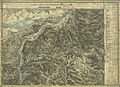
around 1780: Schwarzenbach on the map of the Josephinische Landesaufnahme (on the royal Hungarian border)

1880: Markt Schwarzenbach (far left, bottom) with its nearby Rotten and the eastern surroundings
1880: Most western Schwarzenbacher Rotten (far right below) and northwestern surroundings

1880: South-eastern Schwarzenbacher Rotte (top left, recording sheet of the Franzisco-Josephinische Landesaufnahme )


Web links
- Homepage of the market town of Schwarzenbach
- Homepage on archeology in Schwarzenbach
- Schwarzenbach on the maps of the 2nd military topographical survey 1806–1869
- 32326 - Schwarzenbach (Lower Austria). Community data, Statistics Austria .
- Homepage of the Wirtshausbühne
- Municipal boundaries with neighboring municipalities
Individual evidence
- ↑ University of Klagenfurt - Iron Chest with oil paintings esterházy shear possessions, 1688 , accessed on 15 January 2010
- ^ Result of the local council election 1995 in Schwarzenbach. Office of the Lower Austrian State Government, March 30, 2000, accessed on September 27, 2019 .
- ^ Election result of municipal council election 2000 in Schwarzenbach. Office of the Lower Austrian State Government, February 4, 2005, accessed on September 27, 2019 .
- ^ Election result of the local council election 2005 in Schwarzenbach. Office of the Lower Austrian State Government, March 4, 2005, accessed on September 27, 2019 .
- ^ Election result of the local council election 2010 in Schwarzenbach. Office of the Lower Austrian State Government, October 8, 2010, accessed on September 27, 2019 .
- ^ Election result of the 2015 municipal council election in Schwarzenbach. Office of the Lower Austrian State Government, December 1, 2015, accessed on September 27, 2019 .
- ↑ Results of the local council election 2020 in Schwarzenbach. Office of the Lower Austrian state government, January 26, 2020, accessed on February 9, 2020 .
- ↑ Michael Ladislav: Schwarzenbach . In: The Lower Austrian district of Wiener Neustadt and its communities . 2nd Edition. Lower Austria. Verlag GesmbH, Wiener Neustadt 1996, p. 193 .
- ↑ a b c NÖN: Change in Schwarzenbach: Resignation after 35 years . Article dated December 20, 2018, accessed December 29, 2018.

Bad Erlach | Bad Fischau-Brunn | Bad Schönau | Bromberg | Ebenfurth | Eggendorf | Felixdorf | Gutenstein | Hochneukirchen-Gschaidt | Hochwolkersdorf | High wall | Hollenthon | Katzelsdorf | Kirchschlag in the Bucklige Welt | Krumbach | Lanzenkirchen | Lichtenegg | Lichtenwörth | Market Piesting | Matzendorf-Hölles | Miesenbach | Muggendorf | Pernitz | Pipe in the mountains | Schwarzenbach | Sollenau | Theresienfeld | Waidmannsfeld | Waldegg | Walpersbach | Weikersdorf am Steinfelde | Wiesmath | Winzendorf-Muthmannsdorf | Wöllersdorf-Steinabrückl | Zillingdorf
Cadastral communities: Schwarzenbach
Locations: Schwarzenbach | Schwarzenbach (absent-minded)
Market place: Schwarzenbach Rotten: Eggenbuch | Essengraben | Hocheckgraben | Hochegg | Oberau | Beautiful | Schulau | Meets scattered houses: glass moat | Hackbichl | Königsbichl | Bike school pages | Schölderl | Schwarzenbach (absent-minded)
Counting district: Schwarzenbach